- Home
- :
- All Communities
- :
- Industries
- :
- Education
- :
- Campus Operations Blog
- :
- How To Get Started with No GIS Department or Limit...
How To Get Started with No GIS Department or Limited Staff and Resources
- Subscribe to RSS Feed
- Mark as New
- Mark as Read
- Bookmark
- Subscribe
- Printer Friendly Page
- Report Inappropriate Content
In my previous blog post GIS in Campus Operations: Not a One Size Fits All Solution, we explored the diverse landscape of GIS in campus operations, emphasizing that there is no one-size-fits-all solution. Each campus has unique requirements, starting points, and goals. The subsequent conversations only reinforced this idea, as I delved into discussions with various campuses on how GIS implementations vary widely based on each institution's needs. Whether it's differences in staffing, technical expertise, or budget, every organization faces its own set of challenges when going down the GIS for campus operations road.
One recurring question I was hearing is, “We don’t have a GIS department, how do we get started?” Or “We only have one person leading our GIS efforts—can they manage the whole program alone?” These are excellent questions! The good news is that there are clear steps and strategies to help you succeed. In this post, I’ll share some insights and examples from my experience working with K-12 school districts and higher education institutions to show how different organizations have tackled these challenges.
1) Define Your GIS Purpose and Challenges
Before diving into GIS implementation, it's crucial to pinpoint the specific problems or goals you want to address. A well-defined objective will help identify the right audience and determine the person, people or department responsible for deploying or managing the initiative. Keep in mind that GIS are not stagnant print out or PDF maps you are used to seeing on the wall - it's a dynamic solution that evolves as your organizational needs change. That said, start by focusing on one or two key goals. As your GIS matures, it can grow in complexity, but the best way to begin is with a clear and narrow scope.
2) Identify the Right Person or Department to Lead
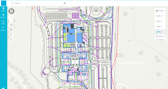
There might be several departments within your organization that are interested in taking charge of GIS operations. For instance, I worked with a large K-12 school district where I converted their CAD floor plans into an ArcGIS Indoors geodatabase and deployed the Indoors Viewer and Space Planning applications. Initially, the GIS department was expected to lead the project, but we soon realized that the Facilities and Construction (F&C) department was better suited to handle the day-to-day management. In this case, the GIS team provided IT support while F&C staff were trained to use and maintain the system. This example illustrates how leadership and management of GIS programs can evolve, just like the technology itself.
3) Don’t Be Afraid to Ask for Help
Ask for help! It’s no secret that I am a consultant, and I’ve seen firsthand how partnering with a GIS consultant or other qualified firms can be incredibly beneficial and cost-effective for campus operations. There are different ways to collaborate with a consultant depending on your needs and keep in mind different consultants and firms offer different services. Based on my experience, here’s a breakdown of how working with a consultant can help:
- Full Deployment and Management Services: If your organization lacks GIS staff or resources, a consultant can handle the entire process—from creating floor plans or maps, to setting up your ArcGIS organization and maintaining it on an ongoing basis. This is an ideal option for institutions that want the benefits of GIS without needing to manage the data and back-end deployment.
- Project Management Support: For organizations with limited GIS expertise, a consultant can act as a program or project manager. I’ve worked with clients where a single person, often without formal GIS training, was tasked with implementing and managing the system simply because they were deemed "tech-savvy." Sound familiar? In these cases, the consultant helps build the GIS environment, educates staff on Esri tools like ArcGIS Indoors, Survey123, Field Maps, and more, and offers training so they can manage it independently. The consultant guides them through the process, ensuring they have the knowledge to maintain the system themselves.
4) Pilot Projects
Whether you're a large organization with a team of 100 GIS professionals or a small, one-person operation with no budget, starting with a pilot project is strongly recommended. A pilot offers a cost-effective, low-risk way to explore how GIS can support your campus operations. It allows you to test workflows and solutions, helping to clarify key details such as roles, processes, and implementation needs. A successful pilot project not only provides a working solution and a guide how to move forward for a full solution implementation, but also helps build a strong case for a full-scale GIS deployment to present to leadership.
The Takeaway
The key takeaway from this blog is that implementing GIS in campus operations requires a tailored approach that aligns with your organization’s unique challenges, whether it's limited staff, technical expertise, or budget constraints. Success starts by defining clear goals and identifying the right individuals or departments to lead the initiative. Don’t hesitate to seek external help when needed—partnering with a GIS consultant can provide invaluable expertise and support. Finally, starting with a pilot project is a crucial, low-risk step to test workflows and build a strong case for a full-scale GIS deployment, ensuring a smooth and effective rollout. No matter the size of your GIS team or the resources you have at your disposal, there are straightforward and scalable options to help you deploy and maintain an efficient GIS program for your campus operations.
If you’re interested in learning more about how GIS could benefit your campus, we encourage you to reach out to colleagues who have implemented similar solutions, read success stories, or get in touch with us directly. You can contact me at zjaffe@map-it-llc.com or visit our website, www.map-it-llc.com. Best of luck on your GIS journey!
About Map I.T.
Map I.T. is a land surveying, GIS, and geospatial consulting firm that leverages cutting-edge solutions to solve organizational challenges, improve decision-making, and boost operational efficiency. With extensive industry experience, we understand every phase of a project’s life cycle, from initial data collection to final deliverables, while providing ongoing support. As an Esri Business Partner and ArcGIS Indoors Specialty Partner, we specialize in GIS solutions for campus operations in K-12 schools, higher education, and beyond.
Zach Jaffe, PLS (SC), founder and CEO of Map I.T., brings over a decade of expertise in land surveying, GIS, and geospatial consulting. He is proficient in a wide range of data collection techniques and is dedicated to delivering impactful solutions to clients. A pioneer in integrating BIM and GIS, Zach is recognized as a thought leader in digital twin technologies, receiving the Esri AEC Hero Award in 2022 for his innovative work in the field.
You must be a registered user to add a comment. If you've already registered, sign in. Otherwise, register and sign in.


