- Home
- :
- All Communities
- :
- Products
- :
- Imagery and Remote Sensing
- :
- Imagery Questions
- :
- Re: Multidimentional Raster Layer
- Subscribe to RSS Feed
- Mark Topic as New
- Mark Topic as Read
- Float this Topic for Current User
- Bookmark
- Subscribe
- Mute
- Printer Friendly Page
Multidimentional Raster Layer
- Mark as New
- Bookmark
- Subscribe
- Mute
- Subscribe to RSS Feed
- Permalink
- Report Inappropriate Content
- Mark as New
- Bookmark
- Subscribe
- Mute
- Subscribe to RSS Feed
- Permalink
- Report Inappropriate Content
What are the other parameters you specified?
Assuming you are using this tool
- Mark as New
- Bookmark
- Subscribe
- Mute
- Subscribe to RSS Feed
- Permalink
- Report Inappropriate Content
I was using the ArcGIS Pro workflow thru 'Add Multidimentional Raster Layer' tool:
Working with a multidimensional raster layer—ArcGIS Pro | ArcGIS Desktop
the 'Make NetCDF Raster Layer' Tool in arcmap does not allow to put in X and Y dimensions
Thank you
- Mark as New
- Bookmark
- Subscribe
- Mute
- Subscribe to RSS Feed
- Permalink
- Report Inappropriate Content
The data is originally in HDF5 format and it is swath data, but been renamed (or converted?) to netCDF file. ArcGIS favors netCDF CF metadata convention, this converted .nc file is not CF compliant.
In Pro 2.4, this data is not supported well. However 2.5, if you rename the extension back to .h5, the data can be displayed

- Mark as New
- Bookmark
- Subscribe
- Mute
- Subscribe to RSS Feed
- Permalink
- Report Inappropriate Content
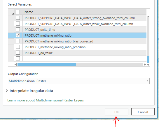
the file came as .nc from ESA Sentinel-5p data hub, was never converted.
renaming to .h5, does not work in ArcPro 2.4, the data band 'PRODUCT_methane_mixing_ratio' is not allowed to be imported.

Thank you,
- Mark as New
- Bookmark
- Subscribe
- Mute
- Subscribe to RSS Feed
- Permalink
- Report Inappropriate Content
Hong Xu indicated that is can be done in ArcGIS Pro 2.5 which is in Beta Testing should you want to test, you could apply