Hi,
How close do two object have to be in order for a SpatialFilter Intersect considers them to be intersecting? I'm doing some testing at a very small scale and getting some 'not expected' results.
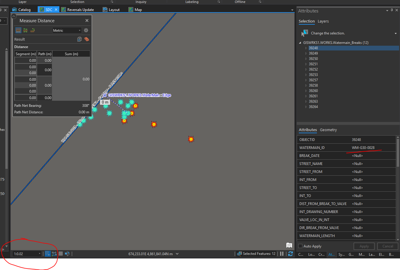
In the screenshot below, I am running the following code to find the intersecting Watermain ID to place onto the Watermain Break point. So basically I pass the point of the selected Watermain Break and the Watermain Layer to this procedure (GetIntersectingFeature), and then update the Watermain Break:
<SPAN class="keyword token">public</SPAN> <SPAN class="keyword token">string</SPAN> <SPAN class="token function">GetIntersectingFeature</SPAN><SPAN class="punctuation token">(</SPAN>MapPoint point<SPAN class="punctuation token">,</SPAN> FeatureLayer intersectLayer<SPAN class="punctuation token">,</SPAN> <SPAN class="keyword token">string</SPAN> fieldName<SPAN class="punctuation token">)</SPAN>
<SPAN class="punctuation token">{</SPAN>
<SPAN class="keyword token">try</SPAN>
<SPAN class="punctuation token">{</SPAN>
<SPAN class="comment token">//ArcGIS.Desktop.Framework.Dialogs.MessageBox.Show(point.X.ToString() + " : " + point.Y.ToString());</SPAN>
<SPAN class="comment token">//Create a Spatial Query using the supplied point, layer and fieldname</SPAN>
SpatialQueryFilter spatialFilter <SPAN class="operator token">=</SPAN> <SPAN class="keyword token">new</SPAN> <SPAN class="token class-name">SpatialQueryFilter</SPAN><SPAN class="punctuation token">(</SPAN><SPAN class="punctuation token">)</SPAN><SPAN class="punctuation token">;</SPAN>
spatialFilter<SPAN class="punctuation token">.</SPAN>FilterGeometry <SPAN class="operator token">=</SPAN> point<SPAN class="punctuation token">;</SPAN>
spatialFilter<SPAN class="punctuation token">.</SPAN>SpatialRelationship <SPAN class="operator token">=</SPAN> SpatialRelationship<SPAN class="punctuation token">.</SPAN>Intersects<SPAN class="punctuation token">;</SPAN>
spatialFilter<SPAN class="punctuation token">.</SPAN>SubFields <SPAN class="operator token">=</SPAN> fieldName<SPAN class="punctuation token">;</SPAN>
<SPAN class="comment token">//Gets the intersecting feature</SPAN>
<SPAN class="keyword token">string</SPAN> fieldValue <SPAN class="operator token">=</SPAN> <SPAN class="keyword token">null</SPAN><SPAN class="punctuation token">;</SPAN>
RowCursor featureCursor <SPAN class="operator token">=</SPAN> intersectLayer<SPAN class="punctuation token">.</SPAN><SPAN class="token function">Search</SPAN><SPAN class="punctuation token">(</SPAN>spatialFilter<SPAN class="punctuation token">)</SPAN><SPAN class="punctuation token">;</SPAN>
Feature feature<SPAN class="punctuation token">;</SPAN>
<SPAN class="comment token">//Gets the value using the fieldName</SPAN>
<SPAN class="keyword token">while</SPAN> <SPAN class="punctuation token">(</SPAN>featureCursor<SPAN class="punctuation token">.</SPAN><SPAN class="token function">MoveNext</SPAN><SPAN class="punctuation token">(</SPAN><SPAN class="punctuation token">)</SPAN><SPAN class="punctuation token">)</SPAN>
<SPAN class="punctuation token">{</SPAN>
<SPAN class="keyword token">using</SPAN> <SPAN class="punctuation token">(</SPAN>feature <SPAN class="operator token">=</SPAN> <SPAN class="punctuation token">(</SPAN>Feature<SPAN class="punctuation token">)</SPAN>featureCursor<SPAN class="punctuation token">.</SPAN>Current<SPAN class="punctuation token">)</SPAN>
<SPAN class="punctuation token">{</SPAN>
<SPAN class="keyword token">int</SPAN> fieldPosition <SPAN class="operator token">=</SPAN> feature<SPAN class="punctuation token">.</SPAN><SPAN class="token function">FindField</SPAN><SPAN class="punctuation token">(</SPAN>fieldName<SPAN class="punctuation token">)</SPAN><SPAN class="punctuation token">;</SPAN>
<SPAN class="keyword token">if</SPAN> <SPAN class="punctuation token">(</SPAN>feature<SPAN class="punctuation token">[</SPAN>fieldPosition<SPAN class="punctuation token">]</SPAN> <SPAN class="operator token">!=</SPAN> <SPAN class="keyword token">null</SPAN><SPAN class="punctuation token">)</SPAN>
fieldValue <SPAN class="operator token">=</SPAN> feature<SPAN class="punctuation token">[</SPAN>fieldPosition<SPAN class="punctuation token">]</SPAN><SPAN class="punctuation token">.</SPAN><SPAN class="token function">ToString</SPAN><SPAN class="punctuation token">(</SPAN><SPAN class="punctuation token">)</SPAN><SPAN class="punctuation token">;</SPAN>
<SPAN class="keyword token">else</SPAN>
fieldValue <SPAN class="operator token">=</SPAN> <SPAN class="keyword token">null</SPAN><SPAN class="punctuation token">;</SPAN>
<SPAN class="punctuation token">}</SPAN>
<SPAN class="punctuation token">}</SPAN>
<SPAN class="keyword token">return</SPAN> fieldValue<SPAN class="punctuation token">;</SPAN>
<SPAN class="punctuation token">}</SPAN>
<SPAN class="keyword token">catch</SPAN> <SPAN class="punctuation token">(</SPAN><SPAN class="token class-name">Exception</SPAN> ex<SPAN class="punctuation token">)</SPAN>
<SPAN class="punctuation token">{</SPAN>
ArcGIS<SPAN class="punctuation token">.</SPAN>Desktop<SPAN class="punctuation token">.</SPAN>Framework<SPAN class="punctuation token">.</SPAN>Dialogs<SPAN class="punctuation token">.</SPAN>MessageBox<SPAN class="punctuation token">.</SPAN><SPAN class="token function">Show</SPAN><SPAN class="punctuation token">(</SPAN><SPAN class="string token">"An error occured while finding the intersecting feature."</SPAN> <SPAN class="operator token">+</SPAN> <SPAN class="string token">"\n"</SPAN> <SPAN class="operator token">+</SPAN> <SPAN class="string token">"\n"</SPAN> <SPAN class="operator token">+</SPAN> ex<SPAN class="punctuation token">.</SPAN><SPAN class="token function">ToString</SPAN><SPAN class="punctuation token">(</SPAN><SPAN class="punctuation token">)</SPAN><SPAN class="punctuation token">,</SPAN> <SPAN class="string token">"GetIntersecingFeature"</SPAN><SPAN class="punctuation token">,</SPAN> System<SPAN class="punctuation token">.</SPAN>Windows<SPAN class="punctuation token">.</SPAN>MessageBoxButton<SPAN class="punctuation token">.</SPAN>OK<SPAN class="punctuation token">,</SPAN> System<SPAN class="punctuation token">.</SPAN>Windows<SPAN class="punctuation token">.</SPAN>MessageBoxImage<SPAN class="punctuation token">.</SPAN>Error<SPAN class="punctuation token">)</SPAN><SPAN class="punctuation token">;</SPAN>
<SPAN class="keyword token">return</SPAN> <SPAN class="keyword token">null</SPAN><SPAN class="punctuation token">;</SPAN>
<SPAN class="punctuation token">}</SPAN>
<SPAN class="punctuation token">}</SPAN><SPAN class="line-numbers-rows"><SPAN></SPAN><SPAN></SPAN><SPAN></SPAN><SPAN></SPAN><SPAN></SPAN><SPAN></SPAN><SPAN></SPAN><SPAN></SPAN><SPAN></SPAN><SPAN></SPAN><SPAN></SPAN><SPAN></SPAN><SPAN></SPAN><SPAN></SPAN><SPAN></SPAN><SPAN></SPAN><SPAN></SPAN><SPAN></SPAN><SPAN></SPAN><SPAN></SPAN><SPAN></SPAN><SPAN></SPAN><SPAN></SPAN><SPAN></SPAN><SPAN></SPAN><SPAN></SPAN><SPAN></SPAN><SPAN></SPAN><SPAN></SPAN><SPAN></SPAN><SPAN></SPAN><SPAN></SPAN><SPAN></SPAN><SPAN></SPAN><SPAN></SPAN><SPAN></SPAN><SPAN></SPAN><SPAN></SPAN><SPAN></SPAN></SPAN>From the screenshot below, all of the selected points have a value returned. I really only should be getting a value returned for the Watermain Breaks that are exactly intersecting the Watermain. Is there a setting I am missing in either ArcGIS Pro, or in my code to tighten up the tolerance of what is considered 'intersecting'??
Thanks,

