Hi,
I have a CSV storing addresses, reference numbers, etc... and also a WKT string of boundary coordinates for each property:

The script (ammended from another user's post in 2012) sccessfully converts the CSV to a shapefile, with the spatial refeence set to EPSG- 27700:
<SPAN class="comment token"># convert well known text to geometry, and compile shapes into a single feature class...</SPAN>
<SPAN class="comment token"># 11/15/2012</SPAN>
<SPAN class="keyword token">import</SPAN> arcpy
File <SPAN class="operator token">=</SPAN> <SPAN class="string token">"C:\\Users\\Team\\Documents\\Theo Laptop Folder\\Tasks\\Quick tasks\\WKTtest\\WKT_to_QGISmakealayerCSV2.csv"</SPAN>
<SPAN class="comment token"># dimension the WKT string field and poly ID field...</SPAN>
<SPAN class="comment token"># the field holding the WKT string...</SPAN>
field1 <SPAN class="operator token">=</SPAN> <SPAN class="string token">"WKT"</SPAN>
<SPAN class="comment token"># the field holding the unique ID...</SPAN>
field2 <SPAN class="operator token">=</SPAN> <SPAN class="string token">"Our_ref"</SPAN>
<SPAN class="comment token"># set up the empty list...</SPAN>
featureList <SPAN class="operator token">=</SPAN> <SPAN class="punctuation token">[</SPAN><SPAN class="punctuation token">]</SPAN>
<SPAN class="comment token"># set the spatial reference to a known EPSG code...</SPAN>
sr <SPAN class="operator token">=</SPAN> arcpy<SPAN class="punctuation token">.</SPAN>SpatialReference<SPAN class="punctuation token">(</SPAN><SPAN class="number token">27700</SPAN><SPAN class="punctuation token">)</SPAN>
<SPAN class="comment token"># iterate on table row...</SPAN>
cursor <SPAN class="operator token">=</SPAN> arcpy<SPAN class="punctuation token">.</SPAN>SearchCursor<SPAN class="punctuation token">(</SPAN>File<SPAN class="punctuation token">)</SPAN>
row <SPAN class="operator token">=</SPAN> cursor<SPAN class="punctuation token">.</SPAN>next<SPAN class="punctuation token">(</SPAN><SPAN class="punctuation token">)</SPAN>
<SPAN class="keyword token">while</SPAN> row<SPAN class="punctuation token">:</SPAN>
<SPAN class="keyword token">print</SPAN> <SPAN class="punctuation token">(</SPAN>row<SPAN class="punctuation token">.</SPAN>getValue<SPAN class="punctuation token">(</SPAN>field2<SPAN class="punctuation token">)</SPAN><SPAN class="punctuation token">)</SPAN>
WKT <SPAN class="operator token">=</SPAN> row<SPAN class="punctuation token">.</SPAN>getValue<SPAN class="punctuation token">(</SPAN>field1<SPAN class="punctuation token">)</SPAN>
<SPAN class="comment token"># this is the part that converts the WKT string to geometry using the defined spatial reference...</SPAN>
temp <SPAN class="operator token">=</SPAN> arcpy<SPAN class="punctuation token">.</SPAN>FromWKT<SPAN class="punctuation token">(</SPAN>WKT<SPAN class="punctuation token">,</SPAN> sr<SPAN class="punctuation token">)</SPAN>
<SPAN class="comment token"># append the current geometry to the list...</SPAN>
featureList<SPAN class="punctuation token">.</SPAN>append<SPAN class="punctuation token">(</SPAN>temp<SPAN class="punctuation token">)</SPAN>
row <SPAN class="operator token">=</SPAN> cursor<SPAN class="punctuation token">.</SPAN>next<SPAN class="punctuation token">(</SPAN><SPAN class="punctuation token">)</SPAN>
<SPAN class="comment token"># copy all geometries in the list to a feature class...</SPAN>
arcpy<SPAN class="punctuation token">.</SPAN>CopyFeatures_management<SPAN class="punctuation token">(</SPAN>featureList<SPAN class="punctuation token">,</SPAN> <SPAN class="string token">"C:\\Users\\Team\\Documents\\Theo Laptop Folder\\Tasks\\Quick tasks\\WKTtest\\WKTShapes.shp"</SPAN><SPAN class="punctuation token">)</SPAN>
<SPAN class="comment token"># clean up...</SPAN>
<SPAN class="keyword token">del</SPAN> row<SPAN class="punctuation token">,</SPAN> temp<SPAN class="punctuation token">,</SPAN> WKT<SPAN class="punctuation token">,</SPAN> File<SPAN class="punctuation token">,</SPAN> field1<SPAN class="punctuation token">,</SPAN> featureList<SPAN class="punctuation token">,</SPAN> cursor<SPAN class="line-numbers-rows"><SPAN></SPAN><SPAN></SPAN><SPAN></SPAN><SPAN></SPAN><SPAN></SPAN><SPAN></SPAN><SPAN></SPAN><SPAN></SPAN><SPAN></SPAN><SPAN></SPAN><SPAN></SPAN><SPAN></SPAN><SPAN></SPAN><SPAN></SPAN><SPAN></SPAN><SPAN></SPAN><SPAN></SPAN><SPAN></SPAN><SPAN></SPAN><SPAN></SPAN><SPAN></SPAN><SPAN></SPAN><SPAN></SPAN><SPAN></SPAN><SPAN></SPAN><SPAN></SPAN><SPAN></SPAN><SPAN></SPAN><SPAN></SPAN><SPAN></SPAN><SPAN></SPAN><SPAN></SPAN><SPAN></SPAN><SPAN></SPAN><SPAN></SPAN><SPAN></SPAN></SPAN>
This is in python 2.7 language fyi. (I'd love this in 3.6 if possible...)
Now when I drag the newly created shapefile into Arc it all looks great, but the fields from the CSV aren't carried across...
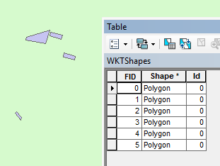
How can I ammend the code to include all the original string fields from the CSV?
thank you

