Hi, I am tryng to publish a relatively simple python script as a geoprocessing service. The tool works well when executed locally. It also publishes correctly, but I get the following error when the geoprocessing service executes:
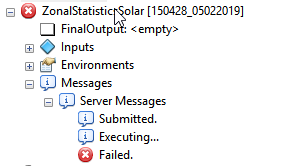
I would like someone to help identify what errors I may have my code, which is attached to this message.
Also, here are the parameters of my script-
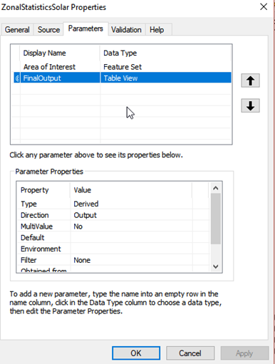
Thanks.
<SPAN class="comment token"># -*- coding: utf-8 -*-</SPAN>
<SPAN class="comment token">#-------------------------------------------------------------------------------</SPAN>
<SPAN class="keyword token">import</SPAN> arcpy
<SPAN class="comment token"># input feature for querying the statistics(feature set)</SPAN>
userInPutFc <SPAN class="operator token">=</SPAN> arcpy<SPAN class="punctuation token">.</SPAN>GetParameterAsText<SPAN class="punctuation token">(</SPAN><SPAN class="number token">0</SPAN><SPAN class="punctuation token">)</SPAN>
<SPAN class="keyword token">if</SPAN> userInPutFc <SPAN class="operator token">==</SPAN> '<SPAN class="comment token">#' or not userInPutFc:</SPAN>
userInPutFc <SPAN class="operator token">=</SPAN> <SPAN class="string token">"\\\\xyz\\Server Objects\\ArcGISGeoprocessing\\Script_ZonalStatistic_Solar\\Data\\Temp\\sotemp.lyr"</SPAN> <SPAN class="comment token"># provide a default value if unspecified</SPAN>
<SPAN class="comment token"># final = arcpy.GetParameterAsText(1)</SPAN>
final <SPAN class="operator token">=</SPAN> <SPAN class="string token">"\\\\xyz\\Server Objects\\ArcGISGeoprocessing\\Script_ZonalStatistic_Solar\\Data\\Temp.gdb\\ZonalSolarOutput"</SPAN> <SPAN class="comment token"># provide a default value if unspecified</SPAN>
<SPAN class="comment token"># work space</SPAN>
arcpy<SPAN class="punctuation token">.</SPAN>env<SPAN class="punctuation token">.</SPAN>workspace <SPAN class="operator token">=</SPAN> <SPAN class="string token">"\\\\xyz\\Server Objects\\Data\\Raster\\Solar"</SPAN>
arcpy<SPAN class="punctuation token">.</SPAN>env<SPAN class="punctuation token">.</SPAN>overwriteOutput<SPAN class="operator token">=</SPAN><SPAN class="token boolean">True</SPAN>
<SPAN class="comment token"># Input rasters array</SPAN>
input_data_array <SPAN class="operator token">=</SPAN> <SPAN class="punctuation token">[</SPAN><SPAN class="punctuation token">]</SPAN>
<SPAN class="comment token"># Exclude data from the analysis</SPAN>
exluded_data <SPAN class="operator token">=</SPAN> <SPAN class="punctuation token">[</SPAN><SPAN class="string token">"PVGIS4_SARAH_YearlyAverageGlobalIrradianceHorizontalSurface"</SPAN><SPAN class="punctuation token">,</SPAN> <SPAN class="string token">"PVGIS4_SARAH_YearlyAverageGlobalIrradianceOptimallyInclinedSurface"</SPAN><SPAN class="punctuation token">,</SPAN> <SPAN class="string token">"PVGIS4_SARAH_YearlyAverageGlobalIrradianceOnTwoAxisSunTrackingSurface"</SPAN><SPAN class="punctuation token">,</SPAN> <SPAN class="string token">"PVGIS4_SARAH_YearlyOptimalInclinationAngleForAnEquatorFacingPlane"</SPAN><SPAN class="punctuation token">,</SPAN> <SPAN class="string token">"SolarGIS_OPTA_OptimumTiltToMaximizeYearlyYield"</SPAN><SPAN class="punctuation token">]</SPAN>
<SPAN class="comment token"># List of geodatabases in the current workspace</SPAN>
workspaceGDBs <SPAN class="operator token">=</SPAN> arcpy<SPAN class="punctuation token">.</SPAN>ListWorkspaces<SPAN class="punctuation token">(</SPAN><SPAN class="string token">"*GIS*"</SPAN><SPAN class="punctuation token">,</SPAN> <SPAN class="string token">"FileGDB"</SPAN><SPAN class="punctuation token">)</SPAN>
arcpy<SPAN class="punctuation token">.</SPAN>AddMessage<SPAN class="punctuation token">(</SPAN>workspaceGDBs<SPAN class="punctuation token">)</SPAN>
<SPAN class="comment token"># extract all the rasters into the input_data_array</SPAN>
<SPAN class="keyword token">for</SPAN> database <SPAN class="keyword token">in</SPAN> workspaceGDBs<SPAN class="punctuation token">:</SPAN>
arcpy<SPAN class="punctuation token">.</SPAN>env<SPAN class="punctuation token">.</SPAN>workspace <SPAN class="operator token">=</SPAN> database
databaseName <SPAN class="operator token">=</SPAN> <SPAN class="punctuation token">(</SPAN>database<SPAN class="punctuation token">.</SPAN>split<SPAN class="punctuation token">(</SPAN><SPAN class="string token">"\\"</SPAN><SPAN class="punctuation token">)</SPAN><SPAN class="punctuation token">[</SPAN><SPAN class="operator token">-</SPAN><SPAN class="number token">1</SPAN><SPAN class="punctuation token">]</SPAN><SPAN class="punctuation token">)</SPAN><SPAN class="punctuation token">.</SPAN>split<SPAN class="punctuation token">(</SPAN><SPAN class="string token">"."</SPAN><SPAN class="punctuation token">)</SPAN><SPAN class="punctuation token">[</SPAN><SPAN class="operator token">-</SPAN><SPAN class="number token">2</SPAN><SPAN class="punctuation token">]</SPAN>
<SPAN class="keyword token">if</SPAN> databaseName <SPAN class="operator token">==</SPAN> <SPAN class="string token">"PVGIS"</SPAN><SPAN class="punctuation token">:</SPAN>
<SPAN class="keyword token">for</SPAN> fd <SPAN class="keyword token">in</SPAN> arcpy<SPAN class="punctuation token">.</SPAN>ListDatasets<SPAN class="punctuation token">(</SPAN><SPAN class="string token">"*_Yearly*"</SPAN><SPAN class="punctuation token">,</SPAN><SPAN class="string token">"Raster"</SPAN><SPAN class="punctuation token">)</SPAN><SPAN class="punctuation token">:</SPAN>
<SPAN class="keyword token">if</SPAN> fd <SPAN class="operator token">not</SPAN> <SPAN class="keyword token">in</SPAN> exluded_data<SPAN class="punctuation token">:</SPAN>
input_data_array<SPAN class="punctuation token">.</SPAN>append<SPAN class="punctuation token">(</SPAN>database <SPAN class="operator token">+</SPAN> <SPAN class="string token">"\\"</SPAN> <SPAN class="operator token">+</SPAN> fd<SPAN class="punctuation token">)</SPAN>
<SPAN class="keyword token">if</SPAN> databaseName <SPAN class="operator token">==</SPAN> <SPAN class="string token">"SolarGIS"</SPAN><SPAN class="punctuation token">:</SPAN>
<SPAN class="keyword token">for</SPAN> fd <SPAN class="keyword token">in</SPAN> arcpy<SPAN class="punctuation token">.</SPAN>ListDatasets<SPAN class="punctuation token">(</SPAN><SPAN class="string token">"*"</SPAN><SPAN class="punctuation token">,</SPAN><SPAN class="string token">"Raster"</SPAN><SPAN class="punctuation token">)</SPAN><SPAN class="punctuation token">:</SPAN>
<SPAN class="keyword token">if</SPAN> fd <SPAN class="operator token">not</SPAN> <SPAN class="keyword token">in</SPAN> exluded_data<SPAN class="punctuation token">:</SPAN>
input_data_array<SPAN class="punctuation token">.</SPAN>append<SPAN class="punctuation token">(</SPAN>database <SPAN class="operator token">+</SPAN> <SPAN class="string token">"\\"</SPAN> <SPAN class="operator token">+</SPAN> fd<SPAN class="punctuation token">)</SPAN>
arcpy<SPAN class="punctuation token">.</SPAN>AddMessage<SPAN class="punctuation token">(</SPAN><SPAN class="string token">"Finished obtaining data from the raster sources"</SPAN><SPAN class="punctuation token">)</SPAN>
arcpy<SPAN class="punctuation token">.</SPAN>env<SPAN class="punctuation token">.</SPAN>overwriteOutput<SPAN class="operator token">=</SPAN><SPAN class="token boolean">True</SPAN>
<SPAN class="comment token"># Create a new environment</SPAN>
out_c <SPAN class="operator token">=</SPAN> <SPAN class="string token">"in_memory"</SPAN> <SPAN class="operator token">+</SPAN> <SPAN class="string token">"\\"</SPAN> <SPAN class="operator token">+</SPAN> <SPAN class="string token">"output_copy"</SPAN>
arcpy<SPAN class="punctuation token">.</SPAN>CopyFeatures_management<SPAN class="punctuation token">(</SPAN>userInPutFc<SPAN class="punctuation token">,</SPAN> out_c<SPAN class="punctuation token">)</SPAN>
arcpy<SPAN class="punctuation token">.</SPAN>CalculateField_management<SPAN class="punctuation token">(</SPAN>out_c<SPAN class="punctuation token">,</SPAN> <SPAN class="string token">"Feature_no"</SPAN><SPAN class="punctuation token">,</SPAN> <SPAN class="string token">"0"</SPAN><SPAN class="punctuation token">,</SPAN> <SPAN class="string token">"PYTHON_9.3"</SPAN><SPAN class="punctuation token">,</SPAN> <SPAN class="string token">""</SPAN><SPAN class="punctuation token">)</SPAN>
<SPAN class="comment token"># Recalculate extent based on the feature</SPAN>
arcpy<SPAN class="punctuation token">.</SPAN>RecalculateFeatureClassExtent_management<SPAN class="punctuation token">(</SPAN>out_c<SPAN class="punctuation token">)</SPAN>
<SPAN class="comment token"># Feature extents</SPAN>
vectorExtent <SPAN class="operator token">=</SPAN> arcpy<SPAN class="punctuation token">.</SPAN>Describe<SPAN class="punctuation token">(</SPAN>userInPutFc<SPAN class="punctuation token">)</SPAN><SPAN class="punctuation token">.</SPAN>extent
vectorExtentXMin <SPAN class="operator token">=</SPAN> vectorExtent<SPAN class="punctuation token">.</SPAN>XMin
vectorExtentYMin <SPAN class="operator token">=</SPAN> vectorExtent<SPAN class="punctuation token">.</SPAN>YMin
vectorExtentXMax <SPAN class="operator token">=</SPAN> vectorExtent<SPAN class="punctuation token">.</SPAN>XMax
vectorExtentYMin <SPAN class="operator token">=</SPAN> vectorExtent<SPAN class="punctuation token">.</SPAN>YMax
<SPAN class="comment token"># Checkout the extension for using in statistics</SPAN>
arcpy<SPAN class="punctuation token">.</SPAN>CheckOutExtension<SPAN class="punctuation token">(</SPAN><SPAN class="string token">"Spatial"</SPAN><SPAN class="punctuation token">)</SPAN>
arcpy<SPAN class="punctuation token">.</SPAN>AddMessage<SPAN class="punctuation token">(</SPAN><SPAN class="string token">"Started processing statistics"</SPAN><SPAN class="punctuation token">)</SPAN>
table <SPAN class="operator token">=</SPAN> <SPAN class="punctuation token">[</SPAN><SPAN class="punctuation token">]</SPAN>
count <SPAN class="operator token">=</SPAN> <SPAN class="number token">0</SPAN>
OI <SPAN class="operator token">=</SPAN> arcpy<SPAN class="punctuation token">.</SPAN>Describe<SPAN class="punctuation token">(</SPAN>out_c<SPAN class="punctuation token">)</SPAN>
field <SPAN class="operator token">=</SPAN> OI<SPAN class="punctuation token">.</SPAN>fields
zone_field <SPAN class="operator token">=</SPAN> <SPAN class="string token">"Feature_no"</SPAN>
arcpy<SPAN class="punctuation token">.</SPAN>AddMessage<SPAN class="punctuation token">(</SPAN><SPAN class="string token">"The zone field is: "</SPAN> <SPAN class="operator token">+</SPAN> zone_field<SPAN class="punctuation token">)</SPAN>
<SPAN class="keyword token">for</SPAN> raster <SPAN class="keyword token">in</SPAN> input_data_array<SPAN class="punctuation token">:</SPAN>
rasterLayerName <SPAN class="operator token">=</SPAN> arcpy<SPAN class="punctuation token">.</SPAN>Describe<SPAN class="punctuation token">(</SPAN>raster<SPAN class="punctuation token">)</SPAN><SPAN class="punctuation token">.</SPAN>name
arcpy<SPAN class="punctuation token">.</SPAN>AddMessage<SPAN class="punctuation token">(</SPAN><SPAN class="string token">"Processing statistics with: "</SPAN> <SPAN class="operator token">+</SPAN> rasterLayerName<SPAN class="punctuation token">)</SPAN>
<SPAN class="comment token"># Raster extents</SPAN>
rasterExtent <SPAN class="operator token">=</SPAN> arcpy<SPAN class="punctuation token">.</SPAN>Describe<SPAN class="punctuation token">(</SPAN>raster<SPAN class="punctuation token">)</SPAN><SPAN class="punctuation token">.</SPAN>extent
rasterExtentXMin <SPAN class="operator token">=</SPAN> rasterExtent<SPAN class="punctuation token">.</SPAN>XMin
rasterExtentYMin <SPAN class="operator token">=</SPAN> rasterExtent<SPAN class="punctuation token">.</SPAN>YMin
rasterExtentXMax <SPAN class="operator token">=</SPAN> rasterExtent<SPAN class="punctuation token">.</SPAN>XMax
rasterExtentYMax <SPAN class="operator token">=</SPAN> rasterExtent<SPAN class="punctuation token">.</SPAN>YMax
<SPAN class="comment token"># Compare vector and raster extents</SPAN>
DXMin <SPAN class="operator token">=</SPAN> rasterExtentXMin <SPAN class="operator token">-</SPAN> vectorExtentXMin
DYMin <SPAN class="operator token">=</SPAN> rasterExtentYMin <SPAN class="operator token">-</SPAN> vectorExtentYMin
DXMax <SPAN class="operator token">=</SPAN> rasterExtentXMax <SPAN class="operator token">-</SPAN> vectorExtentXMax
DYMax <SPAN class="operator token">=</SPAN> rasterExtentYMax <SPAN class="operator token">-</SPAN> vectorExtentYMin
<SPAN class="comment token"># Check if the features share extents</SPAN>
<SPAN class="keyword token">if</SPAN> DXMin <SPAN class="operator token"><</SPAN> <SPAN class="number token">0</SPAN> <SPAN class="operator token">and</SPAN> DYMin <SPAN class="operator token"><</SPAN> <SPAN class="number token">0</SPAN> <SPAN class="operator token">and</SPAN> DXMax <SPAN class="operator token">></SPAN> <SPAN class="number token">0</SPAN> <SPAN class="operator token">and</SPAN> DYMax <SPAN class="operator token">></SPAN> <SPAN class="number token">0</SPAN><SPAN class="punctuation token">:</SPAN>
out_t <SPAN class="operator token">=</SPAN> <SPAN class="string token">"in_memory"</SPAN> <SPAN class="operator token">+</SPAN> <SPAN class="string token">"\\"</SPAN> <SPAN class="operator token">+</SPAN> <SPAN class="string token">"output_table"</SPAN> <SPAN class="operator token">+</SPAN> str<SPAN class="punctuation token">(</SPAN>count<SPAN class="punctuation token">)</SPAN>
arcpy<SPAN class="punctuation token">.</SPAN>sa<SPAN class="punctuation token">.</SPAN>ZonalStatisticsAsTable<SPAN class="punctuation token">(</SPAN>out_c<SPAN class="punctuation token">,</SPAN> zone_field<SPAN class="punctuation token">,</SPAN> raster<SPAN class="punctuation token">,</SPAN> out_t<SPAN class="punctuation token">,</SPAN> <SPAN class="string token">"DATA"</SPAN><SPAN class="punctuation token">,</SPAN> <SPAN class="string token">"SUM"</SPAN><SPAN class="punctuation token">)</SPAN>
arcpy<SPAN class="punctuation token">.</SPAN>AddField_management<SPAN class="punctuation token">(</SPAN>out_t<SPAN class="punctuation token">,</SPAN> <SPAN class="string token">"SourceLayer"</SPAN><SPAN class="punctuation token">,</SPAN> <SPAN class="string token">"TEXT"</SPAN><SPAN class="punctuation token">)</SPAN>
arcpy<SPAN class="punctuation token">.</SPAN>CalculateField_management<SPAN class="punctuation token">(</SPAN>out_t<SPAN class="punctuation token">,</SPAN> <SPAN class="string token">"SourceLayer"</SPAN><SPAN class="punctuation token">,</SPAN> <SPAN class="string token">"'"</SPAN> <SPAN class="operator token">+</SPAN> rasterLayerName <SPAN class="operator token">+</SPAN> <SPAN class="string token">"'"</SPAN><SPAN class="punctuation token">,</SPAN> <SPAN class="string token">"PYTHON_9.3"</SPAN><SPAN class="punctuation token">,</SPAN> <SPAN class="string token">""</SPAN><SPAN class="punctuation token">)</SPAN>
table<SPAN class="punctuation token">.</SPAN>append<SPAN class="punctuation token">(</SPAN>out_t<SPAN class="punctuation token">)</SPAN>
count <SPAN class="operator token">=</SPAN> count <SPAN class="operator token">+</SPAN> <SPAN class="number token">1</SPAN>
<SPAN class="comment token"># final = "\\\\xyz\\Server Objects\\ArcGISGeoprocessing\\Script_ZonalStatistic_Solar\\Data\\Temp.gdb\\ZonalOutput"</SPAN>
arcpy<SPAN class="punctuation token">.</SPAN>Merge_management<SPAN class="punctuation token">(</SPAN>table<SPAN class="punctuation token">,</SPAN> final<SPAN class="punctuation token">)</SPAN>
arcpy<SPAN class="punctuation token">.</SPAN>AddMessage<SPAN class="punctuation token">(</SPAN><SPAN class="string token">"Merged the output table"</SPAN><SPAN class="punctuation token">)</SPAN>
fieldList <SPAN class="operator token">=</SPAN> arcpy<SPAN class="punctuation token">.</SPAN>ListFields<SPAN class="punctuation token">(</SPAN>final<SPAN class="punctuation token">)</SPAN>
<SPAN class="keyword token">for</SPAN> field_of_interest <SPAN class="keyword token">in</SPAN> fieldList<SPAN class="punctuation token">:</SPAN>
<SPAN class="keyword token">if</SPAN> field_of_interest<SPAN class="punctuation token">.</SPAN>name <SPAN class="operator token">==</SPAN> <SPAN class="string token">"SUM"</SPAN><SPAN class="punctuation token">:</SPAN>
arcpy<SPAN class="punctuation token">.</SPAN>AlterField_management<SPAN class="punctuation token">(</SPAN>final<SPAN class="punctuation token">,</SPAN> field_of_interest<SPAN class="punctuation token">.</SPAN>name<SPAN class="punctuation token">,</SPAN> <SPAN class="string token">'SUM_kWh_kWp'</SPAN><SPAN class="punctuation token">,</SPAN> <SPAN class="string token">'SUM_kWh_kWp'</SPAN><SPAN class="punctuation token">)</SPAN>
<SPAN class="keyword token">if</SPAN> field_of_interest<SPAN class="punctuation token">.</SPAN>name <SPAN class="operator token">==</SPAN> <SPAN class="string token">"AREA"</SPAN><SPAN class="punctuation token">:</SPAN>
arcpy<SPAN class="punctuation token">.</SPAN>AlterField_management<SPAN class="punctuation token">(</SPAN>final<SPAN class="punctuation token">,</SPAN> field_of_interest<SPAN class="punctuation token">.</SPAN>name<SPAN class="punctuation token">,</SPAN> <SPAN class="string token">'AREA_SquareMeters'</SPAN><SPAN class="punctuation token">,</SPAN> <SPAN class="string token">'AREA_SquareMeters'</SPAN><SPAN class="punctuation token">)</SPAN>
arcpy<SPAN class="punctuation token">.</SPAN>AddMessage<SPAN class="punctuation token">(</SPAN><SPAN class="string token">"Updated the table fields"</SPAN><SPAN class="punctuation token">)</SPAN>
arcpy<SPAN class="punctuation token">.</SPAN>SetParameterAsText<SPAN class="punctuation token">(</SPAN><SPAN class="number token">1</SPAN><SPAN class="punctuation token">,</SPAN> final<SPAN class="punctuation token">)</SPAN>
arcpy<SPAN class="punctuation token">.</SPAN>AddMessage<SPAN class="punctuation token">(</SPAN>final<SPAN class="punctuation token">)</SPAN><SPAN class="line-numbers-rows"><SPAN></SPAN><SPAN></SPAN><SPAN></SPAN><SPAN></SPAN><SPAN></SPAN><SPAN></SPAN><SPAN></SPAN><SPAN></SPAN><SPAN></SPAN><SPAN></SPAN><SPAN></SPAN><SPAN></SPAN><SPAN></SPAN><SPAN></SPAN><SPAN></SPAN><SPAN></SPAN><SPAN></SPAN><SPAN></SPAN><SPAN></SPAN><SPAN></SPAN><SPAN></SPAN><SPAN></SPAN><SPAN></SPAN><SPAN></SPAN><SPAN></SPAN><SPAN></SPAN><SPAN></SPAN><SPAN></SPAN><SPAN></SPAN><SPAN></SPAN><SPAN></SPAN><SPAN></SPAN><SPAN></SPAN><SPAN></SPAN><SPAN></SPAN><SPAN></SPAN><SPAN></SPAN><SPAN></SPAN><SPAN></SPAN><SPAN></SPAN><SPAN></SPAN><SPAN></SPAN><SPAN></SPAN><SPAN></SPAN><SPAN></SPAN><SPAN></SPAN><SPAN></SPAN><SPAN></SPAN><SPAN></SPAN><SPAN></SPAN><SPAN></SPAN><SPAN></SPAN><SPAN></SPAN><SPAN></SPAN><SPAN></SPAN><SPAN></SPAN><SPAN></SPAN><SPAN></SPAN><SPAN></SPAN><SPAN></SPAN><SPAN></SPAN><SPAN></SPAN><SPAN></SPAN><SPAN></SPAN><SPAN></SPAN><SPAN></SPAN><SPAN></SPAN><SPAN></SPAN><SPAN></SPAN><SPAN></SPAN><SPAN></SPAN><SPAN></SPAN><SPAN></SPAN><SPAN></SPAN><SPAN></SPAN><SPAN></SPAN><SPAN></SPAN><SPAN></SPAN><SPAN></SPAN><SPAN></SPAN><SPAN></SPAN><SPAN></SPAN><SPAN></SPAN><SPAN></SPAN><SPAN></SPAN><SPAN></SPAN><SPAN></SPAN><SPAN></SPAN><SPAN></SPAN><SPAN></SPAN><SPAN></SPAN><SPAN></SPAN><SPAN></SPAN><SPAN></SPAN><SPAN></SPAN><SPAN></SPAN><SPAN></SPAN><SPAN></SPAN><SPAN></SPAN><SPAN></SPAN><SPAN></SPAN><SPAN></SPAN><SPAN></SPAN><SPAN></SPAN><SPAN></SPAN><SPAN></SPAN></SPAN>


