Hi all,
I am new at a company and I'm investigating a problem with a python script we have. The script basically extracts 1000s of rows of property data from a database (QL) and by using X Y data stored in this database, it creates a shapefile which we then use throughout the company.
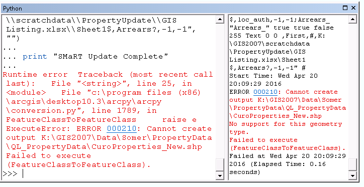
The script was authored by a python expert who doesn't work here anymore. The script worked fine for him, and all the software was on 10.0 at the time. After an upgrade to 10.3 and 10.4, the script doesn't work for us now and throws up an ERROR 000210: Cannot create output K:\ blah blah.. Failed to execute (FeatureClassToFeatureClass). As I'm not that experienced with python scripting and the author of the script isn't around to help, I thought I'd ask here.
Here is the original code that has returned an error, only after upgrading our software from 10.0.
# ---------------------------------------------------------------------------
# All_Curo_Properties.py
# Created on: 2013-03-19 09:26:01.00000
# (generated by ArcGIS/ModelBuilder)
# Description:
# ---------------------------------------------------------------------------
# Import arcpy module
import arcpy
# Overwrite pre-existing files
arcpy.geoprocessing.env.overwriteOutput = True
# Local variables:
Sheet1_ = "K:\\GIS2007\\scratchdata\\PropertyUpdate\\GIS Listing.xlsx\\Sheet1$"
QL_PropertyData = "K:\\GIS2007\\Data\\Somer\\PropertyData\\QL_PropertyData"
Sheet1___2_ = "K:\\GIS2007\\scratchdata\\PropertyUpdate\\GIS Listing.xlsx\\Sheet1$"
QL_PropertyData__2_ = "K:\\GIS2007\\Data\\Somer\\PropertyData\\QL_PropertyData"
Sheet1__Layer = "Sheet1$_Layer"
# Process: Make XY Event Layer
arcpy.MakeXYEventLayer_management(Sheet1___2_, "easting", "northing", Sheet1__Layer, "PROJCS['British_National_Grid',GEOGCS['GCS_OSGB_1936',DATUM['D_OSGB_1936',SPHEROID['Airy_1830',6377563.396,299.3249646]],PRIMEM['Greenwich',0.0],UNIT['Degree',0.0174532925199433]],PROJECTION['Transverse_Mercator'],PARAMETER['False_Easting',400000.0],PARAMETER['False_Northing',-100000.0],PARAMETER['Central_Meridian',-2.0],PARAMETER['Scale_Factor',0.9996012717],PARAMETER['Latitude_Of_Origin',49.0],UNIT['Meter',1.0]];-5220400 -15524400 10000;-100000 10000;-100000 10000;0.001;0.001;0.001;IsHighPrecision", "")
# Process: Feature Class to Feature Class
arcpy.FeatureClassToFeatureClass_conversion(Sheet1__Layer, QL_PropertyData__2_, "CuroProperties_All.shp", "", "prty_id \"prty_id\" true true false 255 Text 0 0 ,First,#,K:\\GIS2007\\scratchdata\\PropertyUpdate\\GIS Listing.xlsx\\Sheet1$,prty_id,-1,-1;alt_prty_i \"alt_prty_i\" true true false 255 Text 0 0 ,First,#,K:\\GIS2007\\scratchdata\\PropertyUpdate\\GIS Listing.xlsx\\Sheet1$,alt_prty_id,-1,-1;Title \"Title\" true true false 255 Text 0 0 ,First,#,K:\\GIS2007\\scratchdata\\PropertyUpdate\\GIS Listing.xlsx\\Sheet1$,Title,-1,-1;Forename \"Forename\" true true false 255 Text 0 0 ,First,#,K:\\GIS2007\\scratchdata\\PropertyUpdate\\GIS Listing.xlsx\\Sheet1$,Forename,-1,-1;Surname \"Surname\" true true false 255 Text 0 0 ,First,#,K:\\GIS2007\\scratchdata\\PropertyUpdate\\GIS Listing.xlsx\\Sheet1$,Surname,-1,-1;fmly_mems \"fmly_mems\" true true false 8 Double 6 15 ,First,#,K:\\GIS2007\\scratchdata\\PropertyUpdate\\GIS Listing.xlsx\\Sheet1$,fmly_mems,-1,-1;add_1 \"add_1\" true true false 255 Text 0 0 ,First,#,K:\\GIS2007\\scratchdata\\PropertyUpdate\\GIS Listing.xlsx\\Sheet1$,add_1,-1,-1;add_2 \"add_2\" true true false 255 Text 0 0 ,First,#,K:\\GIS2007\\scratchdata\\PropertyUpdate\\GIS Listing.xlsx\\Sheet1$,add_2,-1,-1;add_3 \"add_3\" true true false 255 Text 0 0 ,First,#,K:\\GIS2007\\scratchdata\\PropertyUpdate\\GIS Listing.xlsx\\Sheet1$,add_3,-1,-1;add_4 \"add_4\" true true false 255 Text 0 0 ,First,#,K:\\GIS2007\\scratchdata\\PropertyUpdate\\GIS Listing.xlsx\\Sheet1$,add_4,-1,-1;add_5 \"add_5\" true true false 255 Text 0 0 ,First,#,K:\\GIS2007\\scratchdata\\PropertyUpdate\\GIS Listing.xlsx\\Sheet1$,add_5,-1,-1;post_code \"post_code\" true true false 255 Text 0 0 ,First,#,K:\\GIS2007\\scratchdata\\PropertyUpdate\\GIS Listing.xlsx\\Sheet1$,post_code,-1,-1;fulladdr \"fulladdr\" true true false 255 Text 0 0 ,First,#,K:\\GIS2007\\scratchdata\\PropertyUpdate\\GIS Listing.xlsx\\Sheet1$,fulladdr,-1,-1;PropertyTy \"PropertyTy\" true true false 255 Text 0 0 ,First,#,K:\\GIS2007\\scratchdata\\PropertyUpdate\\GIS Listing.xlsx\\Sheet1$,PropertyType,-1,-1;sh_size_de \"sh_size_de\" true true false 255 Text 0 0 ,First,#,K:\\GIS2007\\scratchdata\\PropertyUpdate\\GIS Listing.xlsx\\Sheet1$,sh_size_desn,-1,-1;ShortSizeN \"ShortSizeN\" true true false 255 Text 0 0 ,First,#,K:\\GIS2007\\scratchdata\\PropertyUpdate\\GIS Listing.xlsx\\Sheet1$,ShortSizeName,-1,-1;bed_nos \"bed_nos\" true true false 8 Double 6 15 ,First,#,K:\\GIS2007\\scratchdata\\PropertyUpdate\\GIS Listing.xlsx\\Sheet1$,bed_nos,-1,-1;OwnershipT \"OwnershipT\" true true false 255 Text 0 0 ,First,#,K:\\GIS2007\\scratchdata\\PropertyUpdate\\GIS Listing.xlsx\\Sheet1$,OwnershipType,-1,-1;Landlord \"Landlord\" true true false 255 Text 0 0 ,First,#,K:\\GIS2007\\scratchdata\\PropertyUpdate\\GIS Listing.xlsx\\Sheet1$,Landlord,-1,-1;Landlord1 \"Landlord1\" true true false 255 Text 0 0 ,First,#,K:\\GIS2007\\scratchdata\\PropertyUpdate\\GIS Listing.xlsx\\Sheet1$,Landlord1,-1,-1;landlord3 \"landlord3\" true true false 255 Text 0 0 ,First,#,K:\\GIS2007\\scratchdata\\PropertyUpdate\\GIS Listing.xlsx\\Sheet1$,landlord3,-1,-1;cur_tse_no \"cur_tse_no\" true true false 8 Double 6 15 ,First,#,K:\\GIS2007\\scratchdata\\PropertyUpdate\\GIS Listing.xlsx\\Sheet1$,cur_tse_no,-1,-1;tency_st_d \"tency_st_d\" true true false 8 Date 0 0 ,First,#,K:\\GIS2007\\scratchdata\\PropertyUpdate\\GIS Listing.xlsx\\Sheet1$,tency_st_dt,-1,-1;NeedsDesc \"NeedsDesc\" true true false 255 Text 0 0 ,First,#,K:\\GIS2007\\scratchdata\\PropertyUpdate\\GIS Listing.xlsx\\Sheet1$,NeedsDesc,-1,-1;Source \"Source\" true true false 255 Text 0 0 ,First,#,K:\\GIS2007\\scratchdata\\PropertyUpdate\\GIS Listing.xlsx\\Sheet1$,Source,-1,-1;easting \"easting\" true true false 8 Double 6 15 ,First,#,K:\\GIS2007\\scratchdata\\PropertyUpdate\\GIS Listing.xlsx\\Sheet1$,easting,-1,-1;northing \"northing\" true true false 8 Double 6 15 ,First,#,K:\\GIS2007\\scratchdata\\PropertyUpdate\\GIS Listing.xlsx\\Sheet1$,northing,-1,-1;status \"status\" true true false 255 Text 0 0 ,First,#,K:\\GIS2007\\scratchdata\\PropertyUpdate\\GIS Listing.xlsx\\Sheet1$,status,-1,-1;let_yn \"let_yn\" true true false 2 Short 0 0 ,First,#,K:\\GIS2007\\scratchdata\\PropertyUpdate\\GIS Listing.xlsx\\Sheet1$,let_yn,-1,-1;hb_ref \"hb_ref\" true true false 255 Text 0 0 ,First,#,K:\\GIS2007\\scratchdata\\PropertyUpdate\\GIS Listing.xlsx\\Sheet1$,hb_ref,-1,-1;rent_acc_n \"rent_acc_n\" true true false 8 Double 6 15 ,First,#,K:\\GIS2007\\scratchdata\\PropertyUpdate\\GIS Listing.xlsx\\Sheet1$,rent_acc_no,-1,-1;loc_auth \"loc_auth\" true true false 255 Text 0 0 ,First,#,K:\\GIS2007\\scratchdata\\PropertyUpdate\\GIS Listing.xlsx\\Sheet1$,loc_auth,-1,-1;Arrears_ \"Arrears_\" true true false 255 Text 0 0 ,First,#,K:\\GIS2007\\scratchdata\\PropertyUpdate\\GIS Listing.xlsx\\Sheet1$,Arrears?,-1,-1", "")
print "SMaRT Update Complete"
And this is the error:
We can't experiment and run modified scripts until the evening when no one is working in the office and using the data. So in the meantime, I'd love some of your expert tips!
Thanks.

