The moment when it became clear that GIS, specifically Indoor GIS, would forever change the landscape of facilities information management. And wouldn’t you know it, it was AI that made it “crystal” clear.
For background, reference this previous blog – Three Legs of the Stool: Embracing ArcGIS as Anchor Technology for Facility Operations.
You see, the thing about GIS that has always set it apart from other information systems technologies is its foundation, its “grounding”, its being fundamentally tied to something real, something tangible called geography, a place, a location on the planet earth. It’s literally built into the fabric of the geographic database or geodatabase. The BLOBs or binary large objects in the database actually store geometries for features on this earth … with real “GPS-recognized” X/Y/Z coordinates.
It’s 2026 and for nearly ten years it has puzzled me that facility information systems have continued to organize building or facility information in 0,0 paper space [read: GPS does not recognize 0,0 and pretty much everyone has a smart phone]. The driver has been -- no mystery here -- facility information system technology providers seeking to satisfy business needs with the least amount of effort to answer owner-operator questions while maximizing profit for their software products, i.e., like most things, “it’s just business”. But today, it’s a recognized operations and safety/security issue.
The irony, the almost satirical irony, that AI with its assistants, LLMs, MCP servers, and agentic ecosystems would quietly and quickly drive the benefits of using GIS for outdoor infrastructure and asset management to “the great indoors” … to the world of building/facility/workplace information management. Thus, cranking the door wide-open for fully integrated outdoor-indoor location and operations intelligence. You see, it turns out that organizing one’s building data to support GIS or geodatabase data models delivers seamless outdoor-indoor data analysis and decision support. This was the perfect elixir our AI agents needed … like a shot of adrenaline, it was the moment that changed everything.
How can I exclaim this? Without expounding (because it’s a great story by itself), I’ll simply state that our company, Langan, was asked by Esri to present our “Technology-First Engineering” approach and use of AI on the 2026 Esri Partner Conference and Esri Developer & Technology Summit plenary stages. I.e., our company and Digital Solutions team is pretty “tip-of-spear” … we’ve seen this coming and have been implementing AI into our business for a while now.
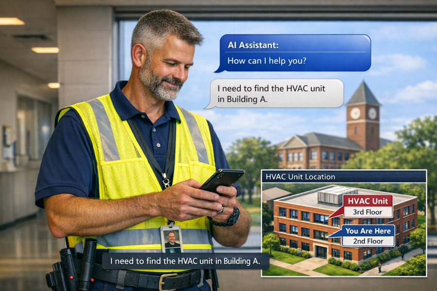
Figure 1 – Future state facility operations is here now. AI-generated image.
From Apps to Platforms: AI is Rewriting the Facilities Tech Stack
You see, we are speeding like a supersonic jet toward platforms as a service – essentially cloud-based collections of tools that can be utilized by AI agents via MCP servers (see Figure 2 below). Leading edge technology providers, like Esri, have known this for over a decade. And it turns out that AI LLMs and agents using these tools actually like structured data. I mean, some systems can show off and do amazing things with unstructured and semi-structured data but if you provide a foundation with structure (based on geography), well … then you have just provided a platform that humans will actually trust with perhaps a little less impact on the [power] grid (yes, like an ecosystem, it all ties together). I mean, if you were a dispatcher directing maintenance professionals or first responders into a factory or a high rise building what would you trust more 0,0 or X/Y/Z?
Esri, Langan, and increasingly many of our clients, understand that it’s time to change the way we think about our data and how we utilize it. We are living in a time where we benefit from unlearning traditional methods of software tool use to serve our business use cases. We will be challenged; dare I say forced to change/rethink our operational models to incorporate and leverage AI platforms and the tools they bring with them (see Figure 1).
Integration Momentum: It’s No Coincidence
The proof is in the pudding. Just look at the juggernaut of AEC technologies, Autodesk. Its joining forces with the global leader of GIS technology, Esri, over the past decade is not coincidental. Yes, their decisions are profit driven (it’s a publicly traded company for goodness sakes) but they are also grounded in sound vision – vision for where as-built designs and “digital twins” -- and their operational/functional use – were headed. In other words, we better get grounded in geography – outdoor-indoor geography – PDQ.
Fast-forward to today, Autodesk and Esri products represent two legs of the stool that are owned by many hundreds of thousands of organizations. Entire countries manage and maintain their democracies with these two technologies [whoa: yes, private land ownership, the key pillar of democracy, a story for another time] and the US government at all levels (fed, state, local) is no surprise the biggest owner/customer.
Which leaves the third leg of the stool, an organizations enterprise system used for managing facility asset and maintenance data (typically an EAM) and/or a system for managing the workplace and building spaces (typically an IWMS). And the lines have been getting blurry over the past decade as EAM and IWMS vendors try to gain market share … we increasingly see EAM-enabled IWMS systems and IWMS/Space data management enabled EAM systems.
And no surprise, it’s geography that blurs the lines.
For example, we see IWMS users pull outdoor utility infrastructure assets (i.e. X/Y/Z data) into 0,0 systems/tools. This is typically done as a cost-saving measure that leads to unnecessary IWMS customization and a dramatic increase in TCO or total cost of ownership. We’ll save that thread for another time as well.
Why EAM/IWMS Matter: And Why They Must Evolve for AI + Integration
Importantly, the third leg of the stool (the EAMs and IWMSs) is vital as it stores and manages the actual “state” of the asset data whether that asset is room space or a fixed asset inside a space. I.e. it stores the type/status/condition or “health” information about an organization’s physical assets. These systems, like Eptura-Archibus or Nuvolo, are important because we humans spend over 80% of our lives indoors and the data they manage helps owner-operators provide healthy, safe, and secure indoor environments.
Stay with me.
Integrated “three legs of the stool” systems (soon collections of published service-based tools that AI agents can pull from) provides the foundation for facilities information management (see Figure 2 below). For an organization to achieve its digital transformation goals and get to an actively “managed” state for its facilities and assets these three legs must be integrated, managed, and utilized for the capabilities they provide. This brings us back to AI. We can actually train an AI agent (or agentic AI) ecosystem to learn our business process workflows and the organizational and data governance required to keep our data current and useful for dynamic (live, real-time) decision support. We can now deliver the reality depicted in Figure 1 above using the architecture in Figure 2 below.
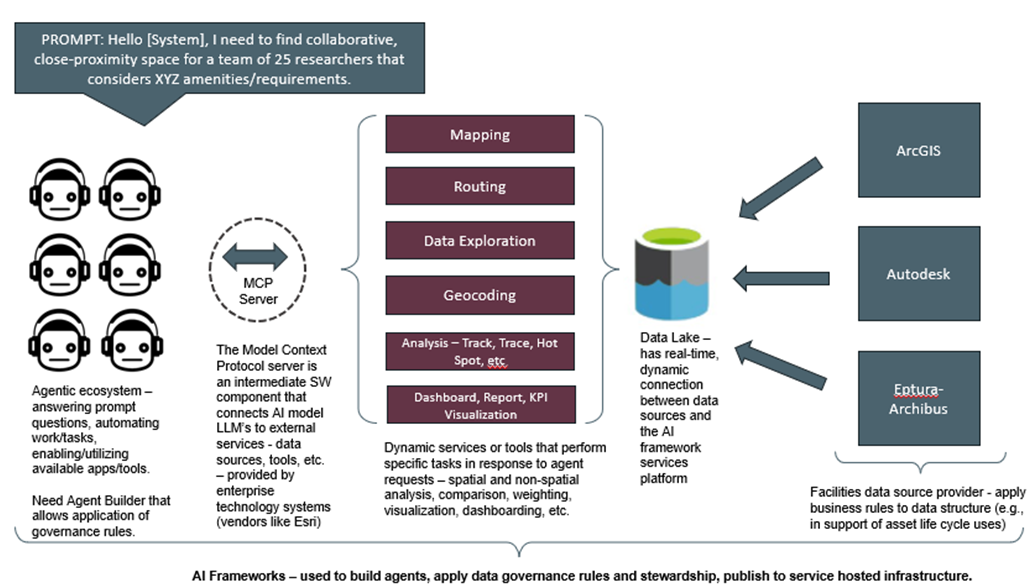
Figure 2 – Human-generated conceptual solution architecture for next generation of facility information management leveraging AI frameworks.
The cost – time and resources – to achieve an actively managed state that supports preventative and predictive analysis and decision support for one’s facilities information will dramatically decrease over the next 1-3 years.
What’s Next: Prompt‑Driven Facilities Apps and Indoor–Outdoor Intelligence
I encourage owner-operators to “keep your eyes open” at upcoming trade shows and events. The AI approach that started being socialized a couple years ago has quickly evolved into (three-leg-of-stool) software provider toolkits. The industry leaders like Esri and Autodesk are actively brining “Agent Builders” to the frontlines of their product and solution stacks. What does this mean? Facility information decision support apps and tools will and are quickly becoming “prompt-driven”. You literally ask a question and describe the format in which you need to see the answer presented and within a couple seconds, a map in a dashboard presents the location of key spaces or assets along with helpful KPI’s.
The addition of Agentic AI has and will continue to change the playing field. We must rethink how we have done things in the past. The ability to ask AI to run an analysis to locate and provide the current condition of a group of assets both inside and outside buildings is here, now, today. I.e., achieving location and operational intelligence has forever changed and we need to lean into those technologies that best support the changing “AI platform” landscape, and use caution when considering extending the use of those [technologies] that cannot answer questions that traverse fully integrated outdoor-indoor environments.
For facility owner-operators and the IT folks supporting their organizations, I suggest taking a serious look at Esri’s ArcGIS Indoors (and Esri’s AI Framework) because it is and will continue to rapidly become a key leg of the stool. It’s not a trend that will fade … just ask Autodesk (or Claude).
The quicker organizations adopt and integrate GIS into their facilities information management technology ecosystem or “tech stack” the quicker they will be able to achieve the significant cost savings coupled with location-intelligent decision support. GIS, Esri’s ArcGIS, will continue to stand out as a key integration platform for achieving digital transformation in the age of AI.
More About the Author and Langan Digital Solutions
Langan Digital Solutions is an Esri Gold Partner with the Indoor GIS Specialty. Associate and senior consultant, John Young, spent 17 years of his career at Esri where he helped start the GIS for real property and facility management practice. He was also instrumental in building the core of what is today’s Indoor GIS. John has devoted his career to building technology and community focused on the application of GIS to improve the planning, operations and safety/security of building facilities. Today, John works with a wide variety of clients to assess and implement improvements for their digital twin and integrated facilities information management technologies. See Langan’s Esri Partner profile.
Reach out to John directly to learn more or simply have a chat about your goals for indoor and facilities GIS at jyoung@langan.com or 980-425-1695.