The MVP Impact Series - Q1 2026
Welcome to our quarterly celebration of Esri Community MVPs - the trusted Esri advocates who dedicate their time and expertise to helping thousands succeed. These elite members embody the spirit of community collaboration, going beyond simply answering questions to provide comprehensive solutions that enable users to overcome technical obstacles and grow their GIS capabilities. In this first Q1 edition, we're highlighting top MVP solutions, must-read blogs, an in-depth MVP spotlight and more.

These notable solutions showcase the depth and breadth of MVP expertise across Esri products and use cases. Each represents comprehensive guidance that helped users overcome complex challenges and advance their projects.
@Neal_t_k as well as a few other MVPs helped a water quality researcher who struggled for 5 months to configure Survey123 to show quality control questions every 10th sample. He provided a working example form using the modulo operator with the once() function, iterating through multiple attempts until the solution worked perfectly.
"Thank you so much for help it finally works!"
@DavidSolari and @Laura assisted a city arborist configure contingency values to allow field workers to enter taxonomy data for tree species not in the pre-configured list. Laura provided a subtype-based solution with step-by-step guidance, while David suggested an "Other" option approach.
"... thanks for the reply"
@DanPatterson helped a user migrate from MapBasic's SearchPoint() function to ArcPy by providing a NumPy-based approach to efficiently test whether a point exists at calculated coordinates. The solution included code examples and tips for working with structured arrays.
"I think this numpy-based approach will give me what I need... Many thanks for all your help."
@NicoleJohnson identified a bug that's causing Experience Builder Cards Widget to fail on mobile and tablet views. She diagnosed the root cause as a conflict between auto-layout headers/footers and accessible labels, providing a workaround that saved the user's weekend beta launch and mentioned this is in product plan for the next release.
"I appreciate you Nicole! We are doing a BETA launch this weekend and were scrambling for a mobile solution. You really got us out of a bind!!!"

These standout contributions recognizes the MVPs who provided the most solutions authored to Community questions during the quarter, demonstrating their technical expertise and commitment to helping users successfully resolve work challenges.
33 18 11
Solutions Authored Solutions Authored Solutions Authored



Blog articles in Esri Community are a platform for thought leadership and educational storytelling, and they often serve as a launch pad for collaboration. MVPs often author articles that inspire the Community to push the boundaries of GIS, fueling a cycle of continuous learning and innovation that elevates the entire Esri ecosystem.
893 Views
Author: @JeffreyThompson2
Jeffrey recaps Dev and Tech Summit 2026 with key updates on Experience Builder enhancements, JavaScript API 6.0 developments, innovative AI features, and accessibility improvements, plus engaging conference highlights and developer insights.
489 Views
Sidebar Custom - Auto Expand when using "Add to table" or "View in Table"
Author: @Brian_McLeer
Brian provides a custom Experience Builder sidebar widget that automatically expands when users add or view data in tables, enhancing user workflow by eliminating manual sidebar expansion steps and supporting widget controller integration.
329 Views
Empowered Data Stewardship: Enable users to monitor their Feature Storage use
Author: @PeterKnoop
Peter shares a Dashboard solution that empowers ArcGIS Online users, particularly in Higher Education, to monitor their Feature Storage usage and practice better data stewardship.

 Ken Buja, Senior Application Developer
The MVP Insights brings you closer to the people behind the contributions, exploring their professional journeys, Community experiences, and the wisdom they've gained. This quarter, we're honored to feature Ken Buja (@KenBuja), who has been an MVP since 2019 and has just retired in March after more than 30 years working with Esri products. As Senior Application Developer at NOAA's National Centers for Coastal Ocean Science, Ken builds applications that transform coastal and marine data into tools used by scientists and communities worldwide. In this conversation that took place ahead of his retirement, Ken reflects on his MVP experience, shares how Community collaboration has shaped his work at NOAA, and offers advice for the next generation of contributors.
1. You've been an MVP since 2019 and are now preparing for retirement in March. Looking back over these years, what has being an MVP meant to you personally and professionally? How has this recognition shaped your approach to contributing to Esri Community?
I am quite proud to be a Community contributor for all these years. Finding out that I was a Community Contest winner for the first time was a terrific way to end my career at NOAA. As an MVP, I pay more attention to the workings of the Community to help guide people along their path. Plus it prods me to improve my contributions.
2. With over 950 solutions authored, you’re clearly an expert in your field and have helped many members over the years in Community. Can you share a memorable moment where the Community helped you overcome a challenge, and how that experience influenced the way you now help others?
For many years, NOAA’s National Centers for Coastal Ocean Science (NCCOS) has been using a participatory GIS process called spatial prioritization to gather information to help determine where NOAA vessels collect data. The first project to use this process utilized a combination of a customized website built with Esri’s Javascript API to explore existing data and an Adobe PDF file that the participants filled out by hand to select their priority areas. The next project used another custom website that integrated the digital atlas and selection process. However, with many more similar projects ahead of us, I couldn’t keep building these one-off websites.
Therefore, I turned to the Web AppBuilder framework to build a widget that could be customized for each new project. With documentation for the framework being very sparse, building a complex widget while learning the framework was an incredibly daunting task. I used the resources of the Community’s predecessor, GeoNet, to tackle that task. Robert Scheitlin was a terrific source of information for many of my questions.
Then it came time to migrate the widget to Experience Builder. While the documentation was a little better than in Web AppBuilder, it was still a challenge to build a widget while learning a new framework. Once again, I turned to the resources of the Community to research my problems and ask more questions. And once again, the Community came to my rescue, with experts like Jeffrey Thompson providing not only direct answers, but other resources like the Tips and Trick user group.
The more detailed responses I’ve received to my questions modified the way I started answering other people’s questions. Instead of providing just a quick response, I would go into more detail, especially with code snippets. I would try to delve more into the logic, providing a line-by-line breakdown of the syntax and links to the documentation for the different functions. By doing this, I hope that others can take the logic and modify it for their scenarios.
3. Your work at NCCOS involves transforming massive datasets about coral health, harmful algal blooms, and coastal ecosystems into applications that serve both scientists and coastal communities. How has your engagement with Esri Community enhanced your ability to deliver these critical tools? Are there specific Community interactions that have directly improved the applications you've built for NOAA's mission?
NCCOS, in partnership with NOAA’s Coral Reef Conservation Program, has been monitoring the health of coral reefs through the National Coral Reef Monitoring Program. One of the key aspects of the program is gathering data on fish populations and coral reef communities in the U.S. Caribbean, Florida, and the Gulf of America. NOAA scientists conduct biological sampling of shallow-water coral reef ecosystems, with divers surveying the seafloor at sites selected for biological diversity. Over the years we have refined the process, using more and more Esri applications to help create a daily dive plan, record which sites the divers have visited, and visualize the data collected.
To ensure that enough sites are sampled for statistical rigor, we use an Esri Dashboard to show how many sites need to be collected at each unique combination of habitat type and location.
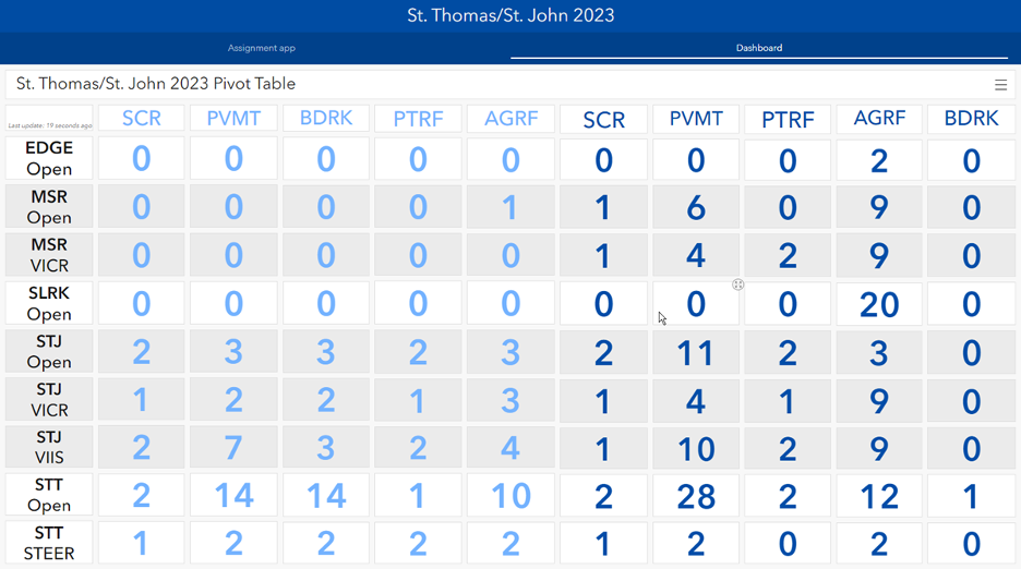
For several missions, I built this dashboard showing the dataset as a pivot table, consisting of individual indicators for each unique combination. It was tedious to build for each mission, but was extremely important, since as the mission proceeds, it becomes critical to focus on areas where not enough sites have been sampled.
As I became more familiar with using Arcade, I started looking for a new way to build this dashboard. Josh Carlson wrote many good posts that showed how to use the power of the GroupBy function and armed with that knowledge, I was able to show all the data in a table using just one script. I also learned how to use the advanced formatting to better visualize the progress from Jennifer Acunto’s “Dashboards That Pop” blogs.

As my colleagues take over this process, it’s now much easier for them to create this Dashboard for future missions by simply changing the dataset in the script.
4. In your Member Spotlight, you've mentioned that altruism drives your participation - wanting to help others who might find it tough to ask for help, because you've been there yourself. What advice would you give to newer Community members who are hesitant to ask questions or share their knowledge?
I’ve always found the Community to be a welcoming place. It contains so many people who have such a wide breadth of knowledge and are willing to help. Taking that initial step of asking your first question can be daunting, but it can lead you in new directions.
And don’t be afraid to share your knowledge. Helping someone solve their problems can provide more insights to you, too. I especially like answering questions that help me learn more about Esri products that I can use in my own projects.
5. As you approach retirement after 30+ years working with Esri products, what do you hope your legacy will be within Esri Community? What message would you like to leave for the next generation of MVPs and Community contributors?
It gives me no greater pleasure than to discover that one of my posts helped someone with a problem they couldn’t solve. I can only hope that the knowledge I’ve passed on through my contributions to the Community keeps on helping people.
Don’t be afraid to be a show-off. Show off your experience by sharing it with others. Show someone the path forward because that helps you on your journey.

MVPs don't just help Community members - they're invaluable partners to Esri staff, helping us solve complex technical challenges, support customers more effectively, and deliver solutions. Here's what our team members have to say about the MVPs who've made a difference in their work.
 Robert Krisher, Product Engineer - Enterprise GIS for UtilitiesSahil (@gis_KIWI4)'s long history with the utility network and willingness to help out new users understand key concepts help get customers up and running with the software without needing to log issues with support every time they run into an obstacle.
 Chris Catania, Head of Esri CommunityAs we shape the future strategy of the Esri Community, the MVPs are one of our most important and trusted customer audiences. Their expertise and perspective directly inform our Community and AI strategy.
In one of those conversations, Joshua Bixby (@JoshuaBixby) raised the question of how AI is impacting community engagement—sparking exactly the kind of dialogue we need more of. His insights, and the discussion that followed, surfaced real opportunities and challenges and helped us strike the right balance between leveraging AI’s value while maintaining authenticity and a strong human‑in‑the‑loop approach.
This is the strategic value of our MVPs: thoughtful leadership, meaningful perspective, and conversations that actively shape how we move forward as a community-driven organization.

The best collaborations are reciprocal. MVPs also want to recognize the Esri staff members who've been instrumental in their Community journey - providing guidance, support, and partnership that makes their contributions possible.
 Simon Schütte, MVP, con terra GmbHChris Underwood (@ChrisUnderwood) consistently keeps community members informed about the status of ongoing issues, ensuring transparency and clarity throughout the process. He is highly reliable when it comes to passing relevant information on to the appropriate Esri teams, helping to ensure that issues are properly addressed. Chris bridges communication effectively between community members and Esri teams and drives matters forward.
 MVPs with President of Esri, Jack Dangermond at Esri User Conference 2025 Esri Awards event. From left: Amanda Huber, Robert Phillips, Jack Dangermond, Chelsea Rozek, and Chris Counsell.
 Every MVP started as a Community member who asked questions, shared knowledge, and built relationships. Interested in the Esri Community MVP Program? Learn more about recognition criteria and benefits. Stay tuned for Q2 2026, where we'll continue highlighting the incredible work happening across Esri Community.



