The Swedish Mapping, Cadastral, and Land Registration Authority creates and maintains the national terrain model, which is regularly updated. In many areas, it provides the best available elevation data. The authority offers the web service "Elevation Direct", which returns elevation values for specific points or breakpoints along a line or polygon.
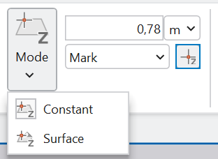
I would like to integrate my code to fetch elevation data from the "Elevation Direct" service with the Elevation framework in ArcGIS Pro. I envision adding it as a custom source that can be selected from the "Mode" dropdown in the "Elevation" group on the "Edit" ribbon tab. This way, when I create new features, they will automatically receive Z-coordinates directly from this source/service.
I am looking for guidance on how to integrate this workflow into ArcGIS Pro.