Hi!
I created non-geo map view and placed 1000 of points.
I want to cluster them using FeatureReduction.
When i start application i can see:
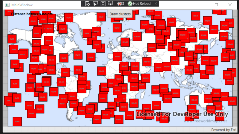
But when I click "draw cluster" i got an error:
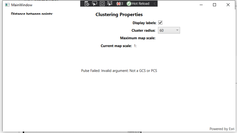
Pulse Failed: Invalid argument: Not a GCS or PCS
Here is my MainWindow.xaml.cs:
using Esri.ArcGISRuntime.ArcGISServices;
using Esri.ArcGISRuntime.Data;
using Esri.ArcGISRuntime.Geometry;
using Esri.ArcGISRuntime.Mapping;
using Esri.ArcGISRuntime.Mapping.Labeling;
using Esri.ArcGISRuntime.Mapping.Popups;
using Esri.ArcGISRuntime.Portal;
using Esri.ArcGISRuntime.Reduction;
using Esri.ArcGISRuntime.Symbology;
using Esri.ArcGISRuntime.UI;
using Esri.ArcGISRuntime.UI.Controls;
using System;
using System.Collections.Generic;
using System.Linq;
using System.Text;
using System.Threading.Tasks;
using System.Windows;
using System.Windows.Controls;
using System.Windows.Data;
using System.Windows.Documents;
using System.Windows.Input;
using System.Windows.Media;
using System.Windows.Media.Imaging;
using System.Windows.Navigation;
using System.Windows.Shapes;

namespace Clusters
{
    /// <summary>
    /// Interaction logic for MainWindow.xaml
    /// </summary>
    public partial class MainWindow : Window
    {
        private FeatureLayer _layer;
        GraphicsOverlay _theGraphicsOverlays;
        GraphicsOverlay _theGraphicsOverlaysNon;
        private ClusteringFeatureReduction _clusteringFeatureReduction;
        public MainWindow()
        {
            InitializeComponent();
            _ = Initialize();
        }


        bool generatePoints = true;
        int countPoints = 200;
        void addIncidents()
        {
            _theGraphicsOverlays = new GraphicsOverlay();

            // Get the graphic collection from the graphics overlay.
            GraphicCollection theGraphicCollection = _theGraphicsOverlays.Graphics;
            SimpleMarkerSymbol theSimpleMarkerSymbol = new SimpleMarkerSymbol(SimpleMarkerSymbolStyle.Square, System.Drawing.Color.Red, 28);
            theSimpleMarkerSymbol.Outline = new SimpleLineSymbol();
            theSimpleMarkerSymbol.Outline.Color = System.Drawing.Color.Black;

            List<Graphic> mapPoints = new List<Graphic>();
            List<Graphic> mapPoints1 = new List<Graphic>();

            if (generatePoints)
            {
                Random random = new Random();
                for (int i = 0; i < countPoints; i++)
                {
                    double x = random.Next(0, 2000); // Replace 10000 with your desired range for X coordinates
                    double y = random.Next(-1000, 0); // Replace 10000 with your desired range for Y coordinates
                    double z = 0; // If you need random Z values, generate them here

                    MapPoint point = new MapPoint(x, y, z);

                    var textSymbol = new TextSymbol
                    {
                        Text = $"{x},{y}",
                        Color = System.Drawing.Color.Black,
                        HaloColor = System.Drawing.Color.White,
                        HaloWidth = 2,
                        Size = 4,
                        VerticalAlignment = Esri.ArcGISRuntime.Symbology.VerticalAlignment.Middle,
                        HorizontalAlignment = Esri.ArcGISRuntime.Symbology.HorizontalAlignment.Center
                    };
                    var compositeSymbol = new CompositeSymbol
                    {
                        Symbols = { theSimpleMarkerSymbol, textSymbol }
                    };

                    mapPoints.Add(new Graphic(point, compositeSymbol));
                    mapPoints1.Add(new Graphic(point, compositeSymbol));
                }
            }

            theGraphicCollection.AddRange(mapPoints);

            MyMapViewNonGeo.GraphicsOverlays.Add(_theGraphicsOverlays);
        }


        private async void LoadRaster(RasterLayer myRasterLayer)
        {
            await myRasterLayer.LoadAsync();

            await MyMapViewNonGeo.SetViewpointGeometryAsync(myRasterLayer.FullExtent);
        }
        private async Task Initialize()
        {
            //MyMapView.Map = new Map(SpatialReferences.WebMercator);

            MyMapViewNonGeo.Map = new Map();

            string filename = System.IO.Path.GetFullPath(@"C:\Files\QuartzTest\QuartzTest\NonGeo\worldmap-countries-hd.jpg");

            // Create the layer
            RasterLayer imageLayer = new RasterLayer(filename);

            LoadRaster(imageLayer);

            MyMapViewNonGeo.Map.Basemap.BaseLayers.Add(imageLayer);


            DrawClustersButton.IsEnabled = true;
            addIncidents();

        }
        private void CreateCustomFeatureReduction()
        {
            try
            {
                // Create a class breaks renderer to apply to the custom feature reduction.
                ClassBreaksRenderer classBreaksRenderer = new ClassBreaksRenderer();
                classBreaksRenderer.DefaultSymbol = new SimpleMarkerSymbol(SimpleMarkerSymbolStyle.Diamond, System.Drawing.Color.White, 24)
                {
                    Outline = new SimpleLineSymbol(SimpleLineSymbolStyle.Solid, System.Drawing.Color.FromArgb(0, 122, 204), 2)
                };
                _clusteringFeatureReduction = new ClusteringFeatureReduction(classBreaksRenderer);

                // Set the feature reduction for the layer.
                //_layer.FeatureReduction = _clusteringFeatureReduction;
                var incidents = MyMapViewNonGeo.GraphicsOverlays.First();
                incidents.FeatureReduction = _clusteringFeatureReduction;

                var simpleLabelExpression = new SimpleLabelExpression("[cluster_count]");
                var textSymbol = new TextSymbol()
                {
                    Color = System.Drawing.Color.Black,
                    Size = 15,
                    HaloColor = System.Drawing.Color.White,
                    HaloWidth = 2
                };
                var labelDefinition = new LabelDefinition(simpleLabelExpression, textSymbol) { Placement = LabelingPlacement.PointCenterCenter };

                // Add the label definition to the feature reduction.
                 //_clusteringFeatureReduction.LabelDefinitions.Add(labelDefinition);
                // Populate the cluster radius and max scale pickers with default values.
                 List<double> items = new List<double> { 0, 1, 2, 3, 4, 5, 6, 10, 15, 30, 45, 60, 75, 90, 100,200,300, 1000 };


                ClusterRadiusPicker.ItemsSource = items;
                // Set initial picker values.
                // Note that the default value for cluster radius is 60.
                // Increasing the cluster radius increases the number of features that are grouped together into a cluster.
                ClusterRadiusPicker.SelectedValue = _clusteringFeatureReduction.Radius;
            }
            catch (Exception ex)
            {

            }


        }


        #region EventHandlers

        private void DisplayLabelsCheckBox_Checked(object sender, RoutedEventArgs e)
        {
            if ((bool)(sender as CheckBox).IsChecked)
            {
                // Create a label definition with a simple label expression.
                var simpleLabelExpression = new SimpleLabelExpression("[cluster_count]");
                var textSymbol = new TextSymbol() { Color = System.Drawing.Color.Black,
                    Size = 15,
                    HaloColor = System.Drawing.Color.White,
                    HaloWidth = 2
                };
                var labelDefinition = new LabelDefinition(simpleLabelExpression, textSymbol) { Placement = LabelingPlacement.PointCenterCenter };

                // Add the label definition to the feature reduction.
                _clusteringFeatureReduction?.LabelDefinitions.Add(labelDefinition);
            }
            else
            {
                _clusteringFeatureReduction.LabelDefinitions.Clear();
            }
        }

        // When a new picker item is selected, update the feature reduction cluster radius.
        private void ClusterRadiusPicker_SelectionChanged(object sender, SelectionChangedEventArgs e)
        {
            if (_layer != null)
            {
                ((ClusteringFeatureReduction)_layer.FeatureReduction).Radius = (double)ClusterRadiusPicker.SelectedItem;
            }
            if (_theGraphicsOverlaysNon != null)
            {
                ((ClusteringFeatureReduction)_theGraphicsOverlaysNon.FeatureReduction).Radius = (double)ClusterRadiusPicker.SelectedItem;
            }
        }


        private void DrawClustersButton_Clicked(object sender, RoutedEventArgs e)
        {
            try
            {
                // Create a new clustering feature reduction.
                CreateCustomFeatureReduction();

                // Show the feature reduction's clustering options.
                ClusteringOptions.Visibility = Visibility.Visible;

                // Hide the draw clusters button.
                DrawClustersButton.Visibility = Visibility.Collapsed;
            }
            catch(Exception ex)
            {

            }
        }

        // Hide and nullify the opened popup when user left clicks.
        private void PopupBackground_MouseLeftButtonDown(object sender, System.Windows.Input.MouseButtonEventArgs e)
        {
            PopupBackground.Visibility = Visibility.Collapsed;
            //PopupViewer.Popup = null;
        }

        #endregion EventHandlers
    }
}Here is MainWindow.xaml
<Window x:Class="Clusters.MainWindow"
        xmlns="http://schemas.microsoft.com/winfx/2006/xaml/presentation"
        xmlns:x="http://schemas.microsoft.com/winfx/2006/xaml"
        xmlns:d="http://schemas.microsoft.com/expression/blend/2008"
        xmlns:mc="http://schemas.openxmlformats.org/markup-compatibility/2006"
        xmlns:local="clr-namespace:Clusters"
        xmlns:quartz="http://schemas.esri.com/arcgis/runtime/2013"
        mc:Ignorable="d"
        Title="MainWindow" Height="450" Width="800">
    <Grid>
        <quartz:MapView x:Name="MyMapViewNonGeo" />
        <Border Width="auto"
                Height="auto">
            <StackPanel Orientation="Vertical">
                <Button x:Name="DrawClustersButton"
                        Padding="5"
                        HorizontalAlignment="Center"
                        Click="DrawClustersButton_Clicked"
                        Content="Draw clusters"
                        IsEnabled="False" />
                <Grid x:Name="ClusteringOptions" Visibility="Collapsed">
                    <Grid.RowDefinitions>
                        <RowDefinition Height="auto" />
                        <RowDefinition Height="auto" />
                        <RowDefinition Height="auto" />
                        <RowDefinition Height="auto" />
                        <RowDefinition Height="auto" />
                    </Grid.RowDefinitions>
                    <Grid.ColumnDefinitions>
                        <ColumnDefinition Width="2*" />
                        <ColumnDefinition Width="*" />
                    </Grid.ColumnDefinitions>
                    <TextBlock Grid.ColumnSpan="2"
                               Padding="5"
                               HorizontalAlignment="Center"
                               FontSize="16"
                               FontWeight="Bold"
                               Text="Clustering Properties" />
                    <TextBlock Grid.Row="1"
                               Grid.Column="0"
                               Padding="5"
                               HorizontalAlignment="Right"
                               VerticalAlignment="Center"
                               FontWeight="Bold"
                               Text="Display labels:" />
                    <CheckBox x:Name="DisplayLabelsCheckBox"
                              Grid.Row="1"
                              Grid.Column="1"
                              VerticalAlignment="Center"
                              Checked="DisplayLabelsCheckBox_Checked"
                              IsChecked="true"
                              Unchecked="DisplayLabelsCheckBox_Checked" />
                    <TextBlock Grid.Row="2"
                               Grid.Column="0"
                               Padding="5"
                               HorizontalAlignment="Right"
                               VerticalAlignment="Center">
                        <Run FontWeight="Bold" Text="Cluster radius:" />
                        <Run Text="{Binding ElementName=ClusterRadiusSlider, Path=Value, Mode=OneWay, StringFormat=n0}" />
                    </TextBlock>
                    <ComboBox x:Name="ClusterRadiusPicker"
                              Grid.Row="2"
                              Grid.Column="1"
                              Width="75"
                              HorizontalAlignment="Left"
                              VerticalAlignment="Center"
                              SelectionChanged="ClusterRadiusPicker_SelectionChanged" />
                    <TextBlock Grid.Row="3"
                               Grid.Column="0"
                               Padding="5"
                               HorizontalAlignment="Right"
                               VerticalAlignment="Center">
                        <Run FontWeight="Bold" Text="Maximum map scale:" />
                        <Run Text="{Binding ElementName=MaxScaleSlider, Path=Value, Mode=OneWay, StringFormat=n0}" />
                    </TextBlock>
                    <TextBlock Grid.Row="4"
                               Grid.Column="0"
                               Grid.ColumnSpan="2"
                               Padding="5"
                               HorizontalAlignment="Center"
                               VerticalAlignment="Center">
                        <Run FontWeight="Bold" Text="Current map scale: " />
                        <Run Text="1:" />
                        <Run Text="{Binding ElementName=MyMapView, Path=MapScale, Mode=OneWay, StringFormat=n0}" />
                    </TextBlock>
                </Grid>

            </StackPanel>
        </Border>
        <TextBlock x:Name="DistanceTextBlock" Foreground="Black"
                    HorizontalAlignment="Left" VerticalAlignment="Center"
					Text="Distance between points: " TextWrapping="Wrap" FontWeight="Bold" Margin="28,10,0,395" Height="auto" Width="266"/>
        <Grid x:Name="PopupBackground"
              Background="#AA333333"
              MouseLeftButtonDown="PopupBackground_MouseLeftButtonDown"
              Visibility="Collapsed">
            <Border HorizontalAlignment="Center"
                    VerticalAlignment="Center"
                    Background="White">
            <!--<quartz:PopupViewer x:Name="PopupViewer"
                                MaxWidth="400"
                                MaxHeight="400"
                                Margin="5"
                                Padding="5" />-->
            </Border>
        </Grid>
    </Grid>
</Window>
My question is do you support clustering at all for Non geo maps, if yes, what should i change to have it working?
Thanks




