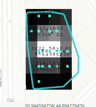
I'm working on creating a batch kriging tool using the Emperical Bayesian Kriging tool. When I run the tool in ArcGIS pro on a selected set of features, the tool runs and creates a nice looking output raster. It looks like this:
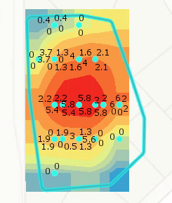
But when I copy that exact tool output from a python window, I get the following code:
arcpy<SPAN class="punctuation token">.</SPAN>ga<SPAN class="punctuation token">.</SPAN>EmpiricalBayesianKriging<SPAN class="punctuation token">(</SPAN><SPAN class="string token">"pond_depth_points"</SPAN><SPAN class="punctuation token">,</SPAN> <SPAN class="string token">"Water_dept"</SPAN><SPAN class="punctuation token">,</SPAN> <SPAN class="string token">"point_geostat"</SPAN><SPAN class="punctuation token">,</SPAN> r<SPAN class="string token">"K:\01696-360\GIS\Maps\2018 Pond Assessment\2018 Pond Assessment.gdb\pond_empbkrig_1"</SPAN><SPAN class="punctuation token">,</SPAN> <SPAN class="number token">0.0001953125</SPAN><SPAN class="punctuation token">,</SPAN> <SPAN class="string token">"NONE"</SPAN><SPAN class="punctuation token">,</SPAN> <SPAN class="number token">100</SPAN><SPAN class="punctuation token">,</SPAN> <SPAN class="number token">1</SPAN><SPAN class="punctuation token">,</SPAN> <SPAN class="number token">100</SPAN><SPAN class="punctuation token">,</SPAN> <SPAN class="string token">"NBRTYPE=StandardCircular RADIUS=0.028516880589107 ANGLE=0 NBR_MAX=15 NBR_MIN=10 SECTOR_TYPE=ONE_SECTOR"</SPAN><SPAN class="punctuation token">,</SPAN> <SPAN class="string token">"PREDICTION"</SPAN><SPAN class="punctuation token">,</SPAN> <SPAN class="number token">0.5</SPAN><SPAN class="punctuation token">,</SPAN> <SPAN class="string token">"EXCEED"</SPAN><SPAN class="punctuation token">,</SPAN> None<SPAN class="punctuation token">,</SPAN> <SPAN class="string token">"POWER"</SPAN><SPAN class="punctuation token">)</SPAN>
<SPAN class="comment token"># which I translate to this in my layer loop:</SPAN>
<SPAN class="keyword token">def</SPAN> <SPAN class="token function">create_raster</SPAN><SPAN class="punctuation token">(</SPAN>points<SPAN class="punctuation token">,</SPAN> workspace<SPAN class="punctuation token">,</SPAN> row_data<SPAN class="punctuation token">,</SPAN> depth_field<SPAN class="punctuation token">)</SPAN><SPAN class="punctuation token">:</SPAN>
raster_name <SPAN class="operator token">=</SPAN> <SPAN class="string token">"kriging_{0}"</SPAN><SPAN class="punctuation token">.</SPAN>format<SPAN class="punctuation token">(</SPAN>row_data<SPAN class="punctuation token">[</SPAN><SPAN class="number token">0</SPAN><SPAN class="punctuation token">]</SPAN><SPAN class="punctuation token">)</SPAN>
<SPAN class="keyword token">try</SPAN><SPAN class="punctuation token">:</SPAN>
<SPAN class="comment token"># raster = arcpy.Kriging_3d(points, depth_field, join(workspace, raster_name), "Spherical ,0.000005", 0.0000953125, "Variable 12")</SPAN>
<SPAN class="comment token"># arcpy.ddd.Kriging(points, depth_field, join(workspace, raster_name), "Spherical 0.000195 # # #", 0.0001953125, "VARIABLE 12 0.00015", None)</SPAN>
<SPAN class="comment token"># raster = arcpy.Kriging_3d(points, depth_field, join(workspace, raster_name),"Spherical 0.2", "0.2", "VARIABLE 8", "")</SPAN>
output_filename <SPAN class="operator token">=</SPAN> join<SPAN class="punctuation token">(</SPAN>workspace<SPAN class="punctuation token">,</SPAN> raster_name<SPAN class="punctuation token">)</SPAN>
output_geostat <SPAN class="operator token">=</SPAN> <SPAN class="string token">'point_geostat'</SPAN>
cell_size <SPAN class="operator token">=</SPAN> <SPAN class="number token">0.0001953125</SPAN>
transformation <SPAN class="operator token">=</SPAN> <SPAN class="string token">"NONE"</SPAN>
max_points <SPAN class="operator token">=</SPAN> <SPAN class="number token">100</SPAN>
local_overlap_factor <SPAN class="operator token">=</SPAN> <SPAN class="number token">1</SPAN>
simulated_semio <SPAN class="operator token">=</SPAN> <SPAN class="number token">100</SPAN>
search_neighborhood <SPAN class="operator token">=</SPAN> <SPAN class="string token">"NBRTYPE=StandardCircular RADIUS=0.028516880589107 ANGLE=0 NBR_MAX=15 NBR_MIN=10 SECTOR_TYPE=ONE_SECTOR"</SPAN>
output_type <SPAN class="operator token">=</SPAN> <SPAN class="string token">"PREDICTION"</SPAN>
semio_model_type <SPAN class="operator token">=</SPAN> <SPAN class="string token">"POWER"</SPAN>
arcpy<SPAN class="punctuation token">.</SPAN>ga<SPAN class="punctuation token">.</SPAN>EmpiricalBayesianKriging<SPAN class="punctuation token">(</SPAN>points<SPAN class="punctuation token">,</SPAN> depth_field<SPAN class="punctuation token">,</SPAN> output_geostat<SPAN class="punctuation token">,</SPAN> output_filename<SPAN class="punctuation token">,</SPAN>
cell_size<SPAN class="punctuation token">,</SPAN> transformation<SPAN class="punctuation token">,</SPAN> max_points<SPAN class="punctuation token">,</SPAN>
local_overlap_factor<SPAN class="punctuation token">,</SPAN> simulated_semio<SPAN class="punctuation token">,</SPAN> search_neighborhood<SPAN class="punctuation token">,</SPAN>
<SPAN class="string token">"PREDICTION"</SPAN><SPAN class="punctuation token">,</SPAN> <SPAN class="number token">0.5</SPAN><SPAN class="punctuation token">,</SPAN> <SPAN class="string token">"EXCEED"</SPAN><SPAN class="punctuation token">,</SPAN> None<SPAN class="punctuation token">,</SPAN> semio_model_type<SPAN class="punctuation token">)</SPAN>
<SPAN class="line-numbers-rows"><SPAN></SPAN><SPAN></SPAN><SPAN></SPAN><SPAN></SPAN><SPAN></SPAN><SPAN></SPAN><SPAN></SPAN><SPAN></SPAN><SPAN></SPAN><SPAN></SPAN><SPAN></SPAN><SPAN></SPAN><SPAN></SPAN><SPAN></SPAN><SPAN></SPAN><SPAN></SPAN><SPAN></SPAN><SPAN></SPAN><SPAN></SPAN><SPAN></SPAN><SPAN></SPAN><SPAN></SPAN><SPAN></SPAN><SPAN></SPAN><SPAN></SPAN><SPAN></SPAN><SPAN></SPAN><SPAN></SPAN></SPAN>When I run this tool and add the output raster to the map, the output raster looks like this. I also noticed the output of the above tool when added to the map also looks like this. Why? Am I doing something wrong here?