Hi, I tried to follow this exact tutorial: Interactive Images in StoryMaps (arcgis.com)
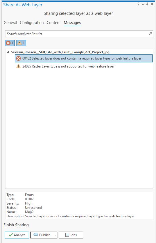
When I come to the step of sharing my selected layer as a web layer, I can't click on Publish or analyze if I choose Tile as layer type. If I choose Feature layer type and analyse before I share, I get this:
To circle back, looks like this was due to not having publishing permissions?
Hi there,
Can you provide a screenshot of the Share As Web Layer General tab as you see it when the options are not selectable?
It won't work as a feature layer without a source layer (feature data).
Hi Aaron,
I am not sure about the source layer. How could I verify I have one? All I know is that my raster is georeferenced as I can see the control points (see picture1). The picture 2 shows the screenshot of the Share As Web Layer General.
Thank you very much !
Thanks for the screenshot!
I have a couple more questions:
2. Have you published anything to your organization before? I am thinking about your permissions and wondering if you have publishing or if it could have been changed for some reason?
I am using the version 2.7.0
Yes I am signed in and I tried on a other layer to see if it would work and I am able to share it easily. So I think the problem comes from my picture.
Thank you !
Nothing looks irregular to me in that screenshot. In the publish dialog, for the name, what if you just give it a truncated name like StillLife as a test? If that doesn't work I'd like to connect you with support as there may be something obvious I am overlooking.
Still not working haha ! I would also like to connect with you for support if that is possible.
Thank you again,
I found your info and had a case logged so someone will reach out to you today. Let's circle back here with the resolution to this. Thanks Marie-Joëlle!
Did you try to save the georeferenced image as a new image so that the sharing recognizes the spatial reference?
That error message looks like you are sharing an image file as a feature later not a tile layer, check the sharing configurations for tile layer settings and options.
Aangemelde leden kunnen berichten plaatsen, updates volgen en meer. Nieuw hier? Registreer een gratis account.
Find useful guides, FAQs, and documents to help you navigate and make the most of Esri Community.