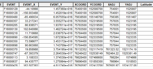
I have 40k points the attribute table has multiple x and y fields all have different numerics. None of them seem to match any coordinate system.
Can someone explain the format of these columns
Projected Coordinate System: NAD_1983_StatePlane_Arizona_Central_FIPS_0202_Feet_Intl
Projection: Transverse_Mercator
False_Easting: 700000.00000000
False_Northing: 0.00000000
Central_Meridian: -111.91666667
Scale_Factor: 0.99990000
Latitude_Of_Origin: 31.00000000
Linear Unit: Foot
thanks


