- I have a static polygon (catchments) layer.
- I have a number of points (river gauges) that have a fixed location, but GeoEvent is updating their flow values every few minutes via an 'Update a feature' output connector.
- Many river gauges can fall within the many catchments.
- Each catchment has a unique ID
- Each river gauge has a unique ID.
- The river gauge has no attribute telling me which catchment it falls within.
I want to update a 'Average Flow' attribute within the catchment layer, to reflect what the current average readings are for the river gauges that fall within it.
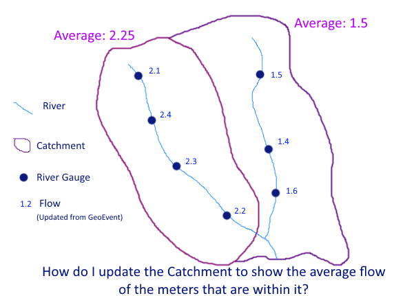
I am sure this should be a simple one to solve, but would like to do this as elegantly as possible.
- I assume that I need to import the catchment layer as a geofence (one off import as never changes)
- Should I be making use of either an incident detector or a spatial processor to find out the underlying gauges within each catchment?
- A field calculator to calculate the average value for these values for each catchment
- An update a feature output connector to send the update to the catchments layer
The bit I am missing is how to summarise the information. How can I turn the 4 events in the left catchment (in figure) into one average value to then send onto the cathment layer, same again but the 3 events for the right catchment?
RJ Sunderman care to put me out of my misery? How would you achieve this?


