I'm sure this is mentioned somewhere in all the UN documentation and best practices, but when it comes to water lines crossing over each other perpendicularly is the easy solution for having an accurate network to elevate either the whole line or part of the line to make sure it's not the same Z-Value as the one it's crossing?
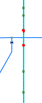
See screenshot below. If we add a new vertex with higher Z-value to each side of the crossing (shown in red), I assume this will cover our need to have different Z-values.
Here's a vertical profile to illustrate how it would look.
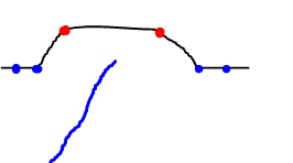
We're not worried about vertically depicting the line perfectly. We don't track Z-Values in our Geometric Network data that will be migrated. Our only concern is making sure there isn't an intersection in the GIS when in real life it crosses over and doesn't actually intersect (i.e. a cross fitting).




