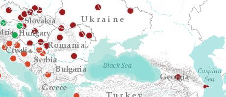
ArcGIS Onlineでシンプルな地図を作成しています。ヨーロッパの複数の都市を含むポイントシェープファイルをインポートし、ベースマップに「ラベル付き地形図」を追加しました。ベースマップ自体は申し分ないのですが、国境や河川、湖、ラベルがポイントの上に表示されます。見た目が不自然なだけでなく、地図も読みづらくなります。たとえば、バクーのポイントがカスピ海に隠れてしまいます。ポイントを再び最前面に表示する方法はありますか?
ご助言をよろしくお願いします。
Sophia,
I believe this is a bug with the particular basemap...the work around is to add the two parts of the basemap separately. Click the Add button and select Search for Layers. Enter terrain in the find section and ensure the drop down next to "In" is set to ArcGIS Online. In the search results find the World Terrain Base item and click on the name then select Use as Basemap. Next find the World Reference Overlay item and add it to the map. Your issue with the weird layering should be resolved.
Have you tried dragging the points layer above the basemap layer (by clicking and holding with your mouse and dragging it upwards)?
Well, yes I tried to change the position but it is fixed at the very bottom anyway and can't be moved.
Thank you very much! I didn't know about that option. It gives many more opportunities to make my map. It looks great now!
サインインしたメンバーは投稿、更新のフォローなどができます。初めてですか?無料アカウントを登録してください。
Find useful guides, FAQs, and documents to help you navigate and make the most of Esri Community.