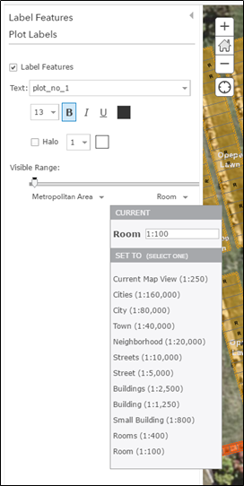
墓地の区画ラベルを、すべての縮尺で表示したいと考えています。 ラベルフィーチャ内で表示縮尺範囲を変更しようとしました(下のスクリーンショットをご覧ください)が、1:100より小さい縮尺には設定できません。100未満の値を入力しても、100に戻ってしまいます。
問題は、火葬区画が約30cm×30cmしかないため、縮尺が1:100でも、3mm四方の区画では3桁の番号ラベルが小さすぎて読めないことです。
1:100未満でもラベルを表示するにはどうすればよいでしょうか?
ほかに有効な方法はありますか?
Hi Naomi,
The available label visible range is determined by the available zoom levels available in your basemap. If you can't zoom in past 1:100, then it won't be possible to set your labels to be visible at a larger scale then what is visible. If you want to zoom in closer, I suggest creating your own basemap that can zoom to larger scales, or using a basemap that zooms in further, like the topographic or imagery basemap that have a max scale of 70.53.
http://www.arcgis.com/home/item.html?id=6e03e8c26aad4b9c92a87c1063ddb0e3
World_Imagery (MapServer)
Choose basemap—ArcGIS Online Help | ArcGIS
-Kelly
Hi Kelly
I currently have this map within a web app. Within the map itself I have allowed zoom to scale of 1:50 and 1:25. When I get past 1:100 the base map turns off and my polygon layers show against a white background. This is desirable when I am looking at a 1:25 scale as at this scale the interest is in the individual cemetery plot scale and its plot number. How would I create a white basemap that turns on automatically once the aerial basemap no longer zooms?
I have currently gotten around this issue by turning the labels into annotation and publishing that as an mxd. This works but is not very flexible.
Thanks for your help,
Naomi
Can you share your map?
サインインしたメンバーは投稿、更新のフォローなどができます。初めてですか?無料アカウントを登録してください。
Find useful guides, FAQs, and documents to help you navigate and make the most of Esri Community.