Before the June 2025 update to AGOL I had successfully developed a way of displaying multiple labels for the same point location showing different attributes for bird territory analysis. This would show a simple label for species, and then a different label (using some arcade and returning text characters) for bird activity. I followed standard ornithology notation, so species would be a two letter code and then activity would be e.g. a circle around the code for singing or a double underline for alarm calling. Example shown below
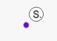
These had to be different labels, to avoid having to catch for every possible combination of species and activity, but the system worked very nicely. Since last month's update the symbols now totally obstruct one another. So every map that I had using this method no longer displays correctly. If I delete the top label, then the second one shows through and vice versa, but seemingly because the labels are located in the same place they now obscure one another totally (this isn't a case of partial obscurity, having tested it, it seems two labels in the same location will deliberately only display the top one). Same point shown below:
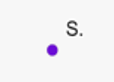
I can't really see the reason for this change, so ideally I'd like it returning to how it was so the multiple maps I already have in this style display as they used to. But if that isn't going to happen I'd like a suggestion as to how I might work around it.





