Drone2MapでDJI Mavic 3 Enterprise (RTK)のサポートを追加してください。<\/P>
M3EはEUのC2カテゴリーにおけるDJIのフラッグシップドローンです。公式に認証されている数少ない機種の一つです(Phantom 4は認証されていません)。<\/P>
Do you mean the Site Scan flight app? Not sure why you couldn't process your Mavic 3 photos through Drone2Map.
Currently I mean Drone2Map, not the Site Scan App.
What I mean is: in Drone2Map the M3E does not show as a camera/drone in the list of cameras you can pick from.
So the question is: do I need to figure out the camera parameters by myself and try to process the M3E photos that way? We tried that. The results were: great orthophoto. Terrible (40m) vertical offset in the terrain model (DTM, DSM). We're using M3E RTK in conjunction with GNSS measured ground control points.
I fly the Mavic 3E and have not had a single issue processing images in Drone2Map. Drone2Map pulls the info from the image metadata. Are you stripping the metadata off the images?
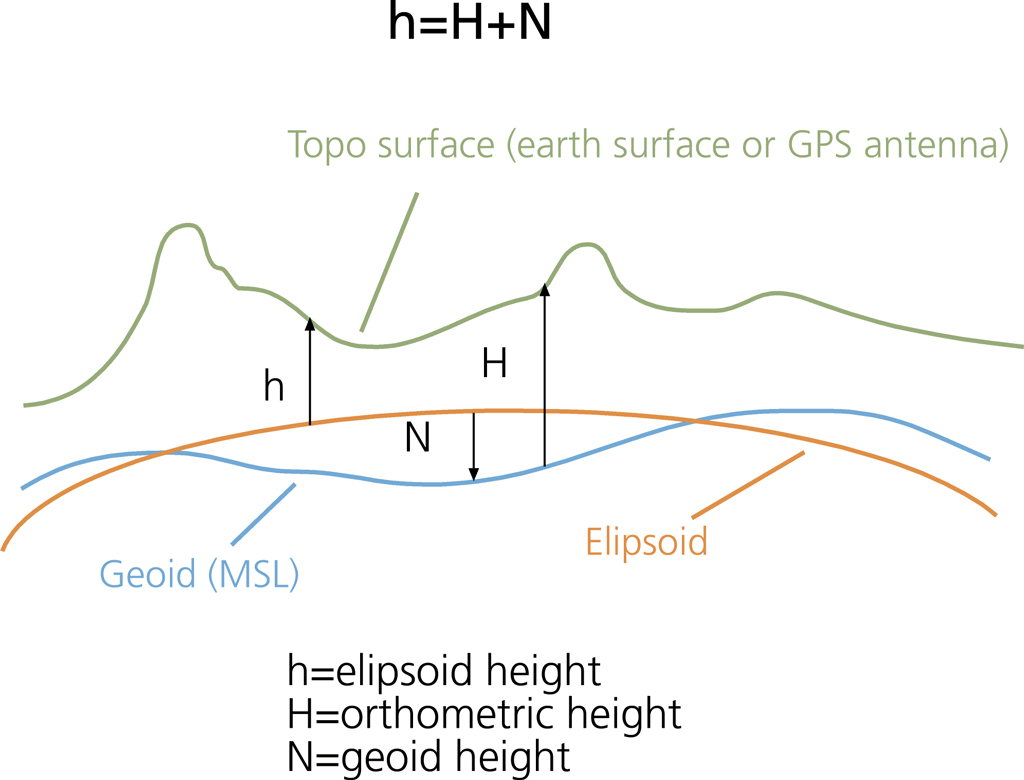
Your 40m shift is most likely caused by the images being the ellipsoidal height and not the orthometric height. Find your geoid height and apply that to your data. See this Esri image:
Thanks, @GIS_Admin !
We're not modifying the images exif information.
We'll look into the orthometric vs. geoid height issue.
I've been having the same height issue between ellipsoid and geoid heights with our Autel Evo RTK. If I process with ground control it corrects it, but just RTK flights have the offset. Drone2Map documentation talks about a height above ellipsoid setting, but I don't think it's still present in the latest release. I guess I need to look into modifying my EXIF data to account for that difference. There is an image heights setting, but I've been having trouble getting it to work.
@OleSeidel1, did you solve this? We are experiencing the same issue. We can fix it with postprocessing but there should be some other way as well I would think.
HI, we have the same problem (see image):
@GIS_Admin: can you specify better how to determine the geoid and how to change height ? Do you mean changing the metadata of images ?
Thanks
Gianni
@AndreasHall , we're still working on it.
We've seperated the issues: One is: depending on your computers operating system language settings, Drone2Map is able to pull camare parameters from your images or not. (Drone2Map doesn't support languace settings where a comma instead of a decimal point is the decimal separator - lacking support for non-US-areas of the world has a long history with Esri and seems still not beeing fully addressed).
The other issue is the coordinate system of your project: You need to know what you're doing and the default settings just don't do the job.
We're now at a Z-accuracy level which is within the few centimeter range (z-RMS-error between 0.03 to 0.08 cm; Mean error between 0 and 8 cm). This is acceptable but not great. Basically the accuracy is as good with the M3E RTK and GNSS measured ground control points as it was before when we were using the Phantom 4 without RTK and also with GNSS measerued ground control points.
Upgrading to an RTK-drone (and upgrading image resulution, upgradeing image quality by faster shutter speed and a mechanical shutter) and flying 45° obliques instead of 30° obliques) we had hoped to get significantly better results. So far, this hasn't happened and we're a bit disillusened. We don't know what to next. Is there something we're missing? Should we go with SiteScan or try pix4D or other vendors solutions instead?
Thanks for the update. I have encountered the decimal separator issue in various circumstances and it could be the case now as well as we are using non-english Windows. We have sent our case to Esri INC Support but have not heard back yet. Hopefully they can identify the issue and fix it in upcoming releases.
You should not experience problems with geoid height if you set the correct horizontal and vertical coordinate system settings for your input images and output project. That said, there seems to be cases when this does not always work.
You should first make sure that you are using correct coordinate information system settings. If you still need to make corrections manually you need to figure out the geoid height in the area where you are. In Sweden, you can download a raster defining the geoid height from the national land survey. To fix raster data, like DEM, you can use ArcGIS Pro and the raster calculator to subtract the geoid height from the DEM. As for the mesh, I am not sure how to fix it.
We did eventually get a bug registered for our issue. BUG-000161833 for ArcGIS Drone2Map (esri.com)
サインインしたメンバーは投稿、更新のフォローなどができます。初めてですか?無料アカウントを登録してください。
Find useful guides, FAQs, and documents to help you navigate and make the most of Esri Community.