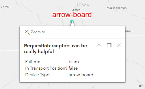
All,
I am trying to make a GeoJSON Layer from a source I do not control. I have a property in the GeoJSON (example below) that is actually an Object, not a string/number, etc, and I am attempting to display labels on the map, but can only access the root objects.
The labelingInfo is the class I am trying to get working properly. As you can see in the linked code pen example, I am unable to get the core_details (or hopefully, core_details.device_type) to display. Any help would be greatly appreciated!
https://codepen.io/AIM_Atlas/pen/QWBQdLa?editors=0010
Spoiler{
"id": "2105CAA6-951D-437C-AA6B-51CF4FB5F8DC",
"type": "Feature",
"geometry": {
"type": "Point",
"coordinates": [
-93.6943733,
41.8766766
]
},
"properties": {
"core_details": {
"device_type": "arrow-board",
"data_source_id": "67899A97-0F3E-4683-B169-75C09C3B8F67",
"device_status": "ok",
"update_date": "2023-01-18T17:11:50Z",
"has_automatic_location": true,
"name": "464",
"description": "Arrow Panel, Display Down",
"serial_number": "0xd0016e"
},
"pattern": "blank",
"is_in_transport_position": false,
"custom": {
"isPublic": false,
"start_date": "2022-10-04T00:59:31",
"location_details": {
"first_date": "2023-01-18T07:38:00",
"update_date": "2023-01-18T17:11:00"
}
}
}
},