Dear members,
I'm using topo to raster to create a base of a geological surface in combination with faults. I thought this would be doable using the Cliff option in topo to raster.
But:
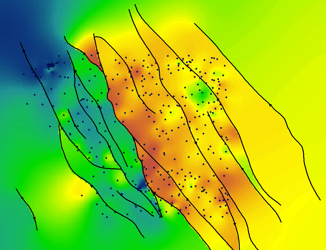
* If I run topo to raster using a sinlge faultline (see result_polyline2_single_fault.pdf) it works.
* If I run topo to raster using a shape with multiple faultlines (see result_polyline3_multple_fault.pdf) the faults are not taken into account (it just runs the ''normal topo to raster function).
The shapes are the same. Orientations are ok. Changing id's does not help, dissolving the multiple faults into one id also does not.
Is it possible anyway to run multiple cliffs at once?
I'm running topo to raster via pyhton 2.7 and arcmap 1.6 (see below).
Can anyone help me out?
Cheers, Freek, Geological Survey of the Netherlands !
p.s.: input datasets are gven in the attachment (file with the single fault, file with the multiple faults and the input borehole data from which I use the field "bottom")
CODE:
#---------------------------------------------------------------------------------------------------
# ArcGIS Geoprocessing instellen
#---------------------------------------------------------------------------------------------------
import sys, string, os, time, arcpy
from arcpy.sa import *
import ReadIniFile
#---------------------------------------------------------------------------------------------------
# ArcGIS overwrite aanzetten
#---------------------------------------------------------------------------------------------------
arcpy.env.overwriteOutput = True
# Check out the ArcGIS Spatial Analyst extension license
arcpy.CheckOutExtension("Spatial")
#-------------------------------------------------------------------------------------
# Ini-file inlezen
#-------------------------------------------------------------------------------------
print "Ini-file lezen ..."
IniFile = ReadIniFile.LoadConfig("verrasteren.ini")
# Gebiedsbegrenzing
xmin = int(IniFile.get("extent.xmin"))
xmax = int(IniFile.get("extent.xmax"))
ymin = int(IniFile.get("extent.ymin"))
ymax = int(IniFile.get("extent.ymax"))
#---------------------------------------------------------------------------------------------------
# Environment settings
#---------------------------------------------------------------------------------------------------
## General settings
print "Environment settings ..."
arcpy.Workspace = IniFile.get("workspace.directory")
arcpy.ScratchWorkspace = IniFile.get("scratchworkspace.directory")
# Extent goed instellen : left, bottom, right, top (!!!)
extent_string = str(xmin) + " " + str(ymin) + " " + str(xmax) + " " + str(ymax)
arcpy.env.extent = extent_string
## Raster Analysis settings
arcpy.env.cellSize = int(IniFile.get("cellsize.cellsize"))
print "-----------------------------------------------------/n"
print "Settings"
print "Workspace : " + arcpy.Workspace
print "ScratchWorkspace : " + arcpy.ScratchWorkspace
print "Cellsize : " + arcpy.env.cellSize
print "-----------------------------------------------------/n"
# Output
out_raster = "c:/Temp/be_base11"
# Input coverages
pointCov1 = "c:/Temp/Be_doorboord.shp "
attributeCov1 = "bottom "
typeCov1 = "PointElevation "
# breuken!!!!
be_breuk_utm = "c:/Temp/polyline2.shp "
outTTR = TopoToRaster([TopoPointElevation([[pointCov1, attributeCov1]]),
TopoCliff([be_breuk_utm])],
"250",
"682000 5685000 715000 5710000",
"20",
"#",
"#",
"NO_ENFORCE",
"SPOT",
"40",
"",
"1",
"0",
"#",
"#",
"#",
"#",
"#",
"#")
outTTR.save(out_raster)