Hi.
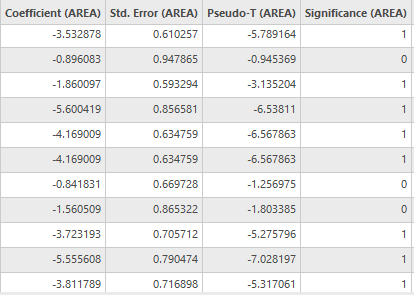
I am running GWR in my research and I don't know what do mean column 'Significance' and 'Pseudo-T' in attribute table after running GWR. These are new column in layer's attribute table after running GWR. What does it mean this 0 and 1? Can anyone help me.
Thank you.
Hi Mirela,
The "Significance" column in the attribute table indicates whether the parameter estimate for each variable is statistically significant or not. A value of 1 indicates that the parameter estimate is significant at the specified level (usually 95% confidence interval) and a value of 0 indicates that the parameter estimate is not significant.
The "Pseudo-T" column in the attribute table represents the t-statistic for each parameter estimate in GWR. The t-statistic measures how many standard errors the estimate is away from zero. The larger the absolute value of the t-statistic, the more significant the estimate. The significance level of the estimate can be determined from the associated p-value.
More about the GWR here:
How Geographically Weighted Regression (GWR) works—ArcGIS Pro | Documentation
Best,
Omar
I got confused regarding the equation used to calculate the Cook’s D.
https://www.machinelearningplus.com/machine-learning/cooks-distance/
https://www.statisticshowto.com/cooks-distance/
https://www.youtube.com/watch?v=PVJYdMjfrAA&t=580s
Hi. The associated p-value can be determed according to the Pseudo-T, Student's table and degrees of freedom.
In my case it was 0.01or 99% significance. I don't know if it vould be determinated before running the GWR.
For other statistical indicator you wrote look at some book about statistic. I also can't find any documentation on them. Local R-Squared is R-Squared for each entity in the attribute table (rows in attribute table).
I hope it helps.
Mirela
Hello. What column is the associated p-value? I have the following fields:
Std. Error, Pseudo-T, Predicted , Residual, Std. Residual, Influence, Cook's D, Condition Number, Local R-Squared. Can you explain each of these? I can't find any documentation on them.
Thank you very much. Yes, it helps.
Geographically Weighted Regression (GWR) (Spatial Statistics)—ArcGIS Pro | Documentation
for reference and see
under Interpreting messages and diagnostics
Les membres connectés peuvent publier, suivre les mises à jour, et plus encore. Nouveau ici ? Inscrivez-vous gratuitement.
Find useful guides, FAQs, and documents to help you navigate and make the most of Esri Community.