Code for test:
<SPAN class="keyword token">var</SPAN> sr <SPAN class="operator token">=</SPAN> mapView<SPAN class="punctuation token">.</SPAN>Map<SPAN class="punctuation token">.</SPAN>SpatialReference<SPAN class="punctuation token">;</SPAN>
<SPAN class="keyword token">var</SPAN> extent <SPAN class="operator token">=</SPAN> mapView<SPAN class="punctuation token">.</SPAN>Extent<SPAN class="punctuation token">;</SPAN><SPAN class="line-numbers-rows"><SPAN></SPAN><SPAN></SPAN></SPAN>
Steps to reproduce the problem:
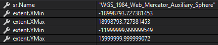
1. Create new project. Variables now will have values:
2. Add layer with WGS84 spatial reference and zoom to full extent (the issue will be without zooming too). Now execute the code above:
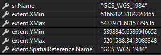
We see that spatial reference now is WGS84, but extent coordinates doesn't correspond to WGS84. Max extent for this sr must be -180 -90 180 90 in degrees, but the values from screenshot are obviously wrong.
More than that I can't project extent to WGS84, because it's already in WGS84, so coordinates still the same!


