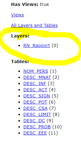
Hi, I recently had issues exporting my survey in FGDB from survey123 web or AGOL portal. Think I just found out whats happening but I don't know what causes this... When I edit a form on the field there's is no point shape for the form so I'm populating tables but there's no geometry associated. Can anyone help me please. Here is my xlsForm.
I'm not really comfortable with indexes but I understand it is normal. Will this layer's REST endpoint will have a higher number than 0 somehow?
Hello Cédric Villeneuve,
The (0) on the REST endpoint comes from the layers index. The index comes from the position of the layer in the maps table of contents.
Please use this link for reference: Using the Services Directory—ArcGIS REST API | ArcGIS for Developers
All geometry layers should be the lowest indexes and then any related tables will be indexed after the geometry layers.
Thank you,
Zach
This is my point. I know Survey123 uses points by default so why do I get (0) when I make forms? (See picture in the post)
When Survey123 surveys are published even without a geopoint, geotrace, or geoshape question the survey will default to a geopoint question as Survey123 will always attempt to capture a devices location even if a geopoint question is not included in the XLSForm.
Currently there is not a way to publish a Survey123 survey that only creates a hosted table, Survey123 will always create a hosted feature service.
If you are seeing issues exporting the data from ArcGIS Online I would suggest opening a ticket with Esri Technical Support and they will be able to assist in diagnosing the error message and reviewing the hosted feature service.
Les membres connectés peuvent publier, suivre les mises à jour, et plus encore. Nouveau ici ? Inscrivez-vous gratuitement.
Find useful guides, FAQs, and documents to help you navigate and make the most of Esri Community.