I have a shapefile that has numerous polygons. I would like to combine polygons that have the same values for some characteristic into larger polygons. I don't think the dissolve function will work because the polygons are not necessarily contiguous (Think parcels of land with streets in between. I want to get a district that contains multiple parcels that may or may not be contiguous.) I don't think aggregate polygons would work either as there are potentially hundreds of these districts in my data set. Any ideas? Thanks.
If i understand what your after correctly i think dissolve will get you want you want it will combine all the polygons contiguous or not and create a single polygon.
Dissolve should work for you:
Dissolve—Help | ArcGIS for Desktop
It will create multi-part polygons for you by default, which means you can dissolve by a field, or multiple fields, with the same attribute(s) - the polygons are not required to be contiguous.
Dissolve is fine if there is some need to adjoin adjacent land parcels...for instance, same landuse and/or owner etc etc. I generally recommend against this since I is far simpler to have singlepart poly* features than multipart. In fact, many geoprocessing functions only work properly when you have singlepart features (ie determining the centre of a polygon or simply counting the number of one type.
So do you have a particular reason to do this. Is it to save file size? Have you considered that a layer could be split based upon its attributes rather than aggregating geometry? (ie group residential land use into one layer...). Any insight into why you need/want to do this might provide some suggestions on how it affects your workflow and how you might benefit from alternates yet maintain the integrity of the geometry and its attributes.
Thanks for the advice. What I am trying to do is create polygons for different special tax assessment zones. These are not currently geo-coded. So I am trying to aggregate separate land parcels (not contiguous) into one assessment zone. I then want to do some geoprocessing with the larger assessment zones. Does this make sense?
When you run the dissolve you will be asked where to save the new feature class, so you wont be hurting anything to test. Give it a test and see what happens.
Why not simply query for the assessment zone attribute, which I assume you have. Once queries, you can save the selection to its own layer and not have to worry about that criterion again since any operations will apply to it. When you are done, you can simply delete it. The advantage is that you don't have to worry about going to the trouble of limiting the operation to that class. Currently, I can't see any geoprocessing function which would be advantaged by consolidating the geometry. Also what do you do about the cases that the primary class is one type but the secondary, tertiary.... are different types? How do you plan to accommodate for that when you geoprocessing operation changes to something else?
Hi Dan:
Bear with me here if you will. I tried using dissolve, and got the multipart polygon. I can see why that is an issue and it does not solve my question. So I could certainly split the data into multiple layers based on each tax assessment district. But what I would get is hundreds of parcels in each layer with the same tax assessment district number, but as distinct polygons. How would I go about constructing the district itself. For instance, I would like the centroid of the district or the area of the district.
Thanks,
Andrew
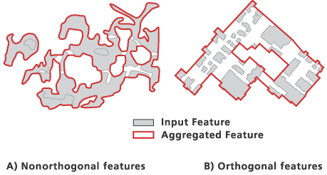
Since you mention Aggregating polygons and that Dissolve doesn't work, I assume you've tried the Aggregate tool...? Does it produce the results you're after, and you're looking for a way to automate cycling through each district, or does it not produce the results you want at all?
Is this the situation you're describing?:
Yes but...
Yes, but...
- if he's already using the Aggregate tool, he must have ArcInfo
- if you're automating the aggregate by attribute, then you may as well carry over the attribute at the same time (using Python)
I suspect what he is referring to is that the polygons aren't aggregated completely in space. If they were then you still have the problem of the aggregation of the attributes as you get with dissolve. Unless I am wrong, he wants to split the data into bits based upon the district. Each district will consist of many polygons, but at least you can retain the attributes. All he want to do is skip the select by attributes step prior to doing what he wants in the geoprocessing environment. Of course, this can be done on individual files as I suggested, or it can be automated in a script whereby, a select by attributes, is performed first, then geoprocessing function next, on to the next. No mention was made of scripting otherwise I would have offered up some alternates that exist or that I have in NumPy world. We await...
just to throw something completely different into the mix, in case the suggestions from the others don't do what you need, have you looked into subtypes? You would want to first import you shape file into a FGDB, but then you could use A quick tour of subtypes—Help | ArcGIS for Desktop to help categorize a common group of attributes without actually changing the data and polygons. I would suggest adding a field, calculating a unique value based on the attributes you are are wanting to group, and using that field as your subtype. That makes it quick to visualize/symbolize the various grouping you want and you can always use that field then to extract to a temp file for calculation....if you can't use the file as a whole (with the new field).
Anyway, just wanted to throw that out since sometimes I know I get fixated on one line of thought (dissolve, aggregate, etc.) and forget that adding a field and calculating can sometime do what I need just as fast.
Les membres connectés peuvent publier, suivre les mises à jour, et plus encore. Nouveau ici ? Inscrivez-vous gratuitement.
Find useful guides, FAQs, and documents to help you navigate and make the most of Esri Community.