Hi,
recently I`ve taken over the development support of a larger silverlight mapping application in our company. Unfortunately there`s currently no one here who`s familiar with the application and I`ve to fix several Bugs after we migrated from ArcGIS Server 10 to 10.2.2.
One problem belongs to a FeatureDataForm
<esri:FeatureDataForm Grid.Row="1" Grid.Column="0" x:Name="myFeatureDataForm" CommitButtonContent="OK" HorizontalAlignment="Left" ScrollViewer.VerticalScrollBarVisibility="Visible" ScrollViewer.HorizontalScrollBarVisibility="Visible" EditEnded="myFeatureDataForm_EditEnded"
IsReadOnly="False" LabelPosition="Left" Margin="5,5,5,5">
</esri:FeatureDataForm>
I initialize the form as follows:
FeatureLayer fl = getFeatureLayer(al.TabellenLayerID);
myFeatureDataForm.FeatureLayer = fl;
myFeatureDataForm.GraphicSource = fl.Graphics.First();
It references a table layer:
<esri:FeatureLayer ID="abschnittSanierungsbedarf" Url="/arcgis/rest/services/private/fis_deiche_event_layers_featureservice/FeatureServer/23"
ProxyUrl="../apps/fisdeiche/proxy.ashx"
DisableClientCaching="True"
AutoSave="False"
OutFields="FUNKTIONSTUECHTIGKEIT, SANPRIORITAET, JAHR_LETZTE_SAN"
Mode="OnDemand"
MaximumResolution="16"
/>
I get back domains from the server, see the following state during debugging:
?myFeatureDataForm.FeatureLayer.LayerInfo.Fields[5].Domain
{ESRI.ArcGIS.Client.FeatureService.CodedValueDomain}
[ESRI.ArcGIS.Client.FeatureService.CodedValueDomain]: {ESRI.ArcGIS.Client.FeatureService.CodedValueDomain}
Name: "FISD_SANIERUNG_FUNKTION"
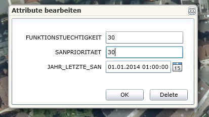
But I don`t get drop downs with coded values in my panel.
The REST endpoint of this layer loos as follows:
Layer: GEWIS.GEW_HWD_SANFUNKBEDARF (ID: 23)
Name: GEWIS.GEW_HWD_SANFUNKBEDARF
Display Field: HWD_NR_TEXT
Type: Table
Geometry Type: N/A
Description:
Definition Expression: N/A
Copyright Text:
Default Visibility: false
MaxRecordCount: 10000
Supported Query Formats: JSON, AMF
Supports Advanced Queries: true
Supports Statistics: true
Use Standardized Queries: true
Extent:
Drawing Info:
N/A
HasZ: false
HasM: false
Has Attachments: false
HTML Popup Type: esriServerHTMLPopupTypeNone
Type ID Field:
Fields:
OBJECTID ( type: esriFieldTypeOID , alias: OBJECTID , editable: false , nullable: false )
HWD_NR ( type: esriFieldTypeDouble , alias: HWD_NR , editable: true , nullable: false )
BASISSTATIONIERUNG_VON ( type: esriFieldTypeInteger , alias: BASISSTATIONIERUNG_VON ,
editable: true , nullable: false )
BASISSTATIONIERUNG_BIS ( type: esriFieldTypeInteger , alias: BASISSTATIONIERUNG_BIS ,
editable: true , nullable: false )
ABSCHNITTLAENGE ( type: esriFieldTypeInteger , alias: ABSCHNITTLAENGE , editable: true ,
nullable: true )
FUNKTIONSTUECHTIGKEIT ( type: esriFieldTypeSmallInteger , alias: FUNKTIONSTUECHTIGKEIT ,
editable: true , nullable: true , Coded Values: [0: k.A.] , [10: n.s.bed.] , [20: saniert] , ...2 more...
)
SANPRIORITAET ( type: esriFieldTypeSmallInteger , alias: SANPRIORITAET , editable: true ,
nullable: true , Coded Values: [10: sehr hoch] , [20: hoch] , [30: mittel] , ...3 more... )
JAHR_LETZTE_SAN ( type: esriFieldTypeDate , alias: JAHR_LETZTE_SAN , editable: true , nullable:
true , length: 36 )
HWD_NR_TEXT ( type: esriFieldTypeString , alias: HWD_NR_TEXT , editable: true , nullable: true ,
length: 50 )
Templates:
Name: GEWIS.GEW_HWD_SANFUNKBEDARF
Description:
Prototype:
HWD_NR_TEXT: null
HWD_NR: 0
BASISSTATIONIERUNG_VON: 0
BASISSTATIONIERUNG_BIS: 0
ABSCHNITTLAENGE: null
FUNKTIONSTUECHTIGKEIT: null
SANPRIORITAET: null
JAHR_LETZTE_SAN: null
Drawing Tool: esriFeatureEditToolNone
Capabilities: Create, Delete,Query,Update,Uploads,Editing
Sync Can Return Changes: false
Is Data Versioned: false
Supports Rollback On Failure: true
Supported Operations: Query Apply Edits
Do you have any suggestions for me?
Thank you for help!

