I just began using the latest Drone2Map and I am receiving an error at the end of initial processing in regards failing to create the mosaic dataset. Since the mosaic dataset is not created the Estimate Links is not enabled in the Image Links Editor. I am just running the initial step so I can use the Assisted Link feature using my imported GPS collected control points.
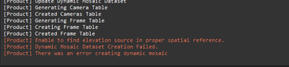
From the D2M log:

My GPS data is in WGS84 with vertical reference GEOID12. In previous Drone2Map releases, I just left everything default and things worked smoothly. Do I need to adjust anything now when importing control points from a feature class? Please let me know what additional information would help.
Thank you


