Hi everyone, my name is Nico Mora. For the past 11 months, I have been working toward my master’s degree in GIS at the University of Redlands. The university offers two graduate tracks: a Master of GIS, which culminates in an internship, and a Master of Science in GIS, which culminates in a major individual project applying GIS to address a client’s real-world problem. I chose the former because I was hoping to land a summer internship at Esri, but I was still very interested in completing an individual project, so I completed an independent study on sidewalks as a compromise.
An independent study is a course format allowing students to pursue a topic of interest through self-guided research and analysis. Although it's underused and little-advertised as an option in graduate GIS programs, an independent study can be a powerful way to lead yourself in gaining deep, project-based research experience that your standard coursework may not offer on its own. Although my study didn’t involve an external client, I learned just as much about applying GIS to sidewalk management. In this blog post, I’ll outline how I approached my independent study and share key lessons that may help you pursue your own path in GIS.
Getting my independent study started
I knew I was interested in studying sidewalks. After tripping over a displaced sidewalk panel for the umpteenth time while out running, I wondered, “Can’t GIS be used to make Redlands safer for us pedestrians out here?” As it turns out, Esri had just launched version 1.0 of Sidewalk Management, an ArcGIS Solution for organizations to, well, manage sidewalks. It includes a preconfigured geodatabase and a suite of ArcGIS apps that allow state and local governments to generate a sidewalk inventory, assess sidewalk conditions, and visualize compliance with ADA regulations. Basically, it provides the GIS tools needed for sidewalk management, just not the manpower to use them.
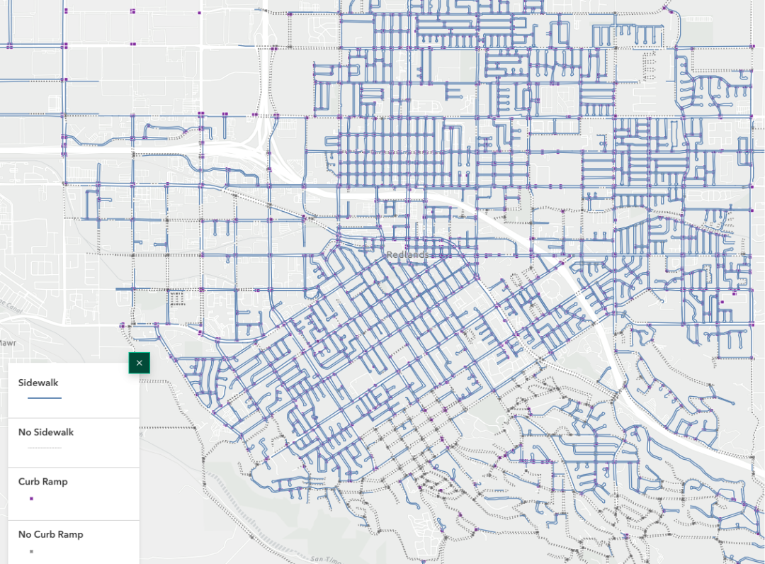
A map showing the sidewalk infrastructure network in Redlands, CA, including the locations of street sides without sidewalks and street intersections without curb ramps.
I emailed my department chair to request a meeting to discuss my interest and, in advance, prepared a proposal that included context on the problem of sidewalks and Esri’s Sidewalk Management solution, possible research questions, and a list of known existing datasets for Redlands, which I had identified through a Google search and email outreach to the GIS offices at the City of Redlands and San Bernardino County. For good measure, I mentioned some of the limitations the project would face, such as the limited time I could realistically dedicate to collecting field data on sidewalk conditions. My hope was that coming prepared would help me feel confident and increase the chances of securing departmental approval. Sure enough, he authorized my independent study request and even agreed to be my advisor. The last step before starting the project was to submit a form to the registrar’s office detailing my plan of study.
The project process
The rest of my fall semester was spent doing a deep dive into Sidewalk Management. To start, I obtained the datasets from the City and County. They provided a substantially complete inventory of the sidewalk network, although it was missing recently constructed sidewalks, as it had not been updated since 2020. I also carefully read Esri’s documentation for the solution to understand how to configure and use its various apps correctly. After importing the data into the solution geodatabase, I focused on two key capabilities: the tools for analyzing sidewalk conditions and a deep learning (geospatial AI) model for detecting sidewalks in aerial imagery.
As I alluded to before, the main problem with sidewalk conditions in Redlands is the prevalence of vertical faults that create tripping hazards. I walked around a few neighborhoods with a yardstick to measure the heights of these faults and a smartphone to record their locations and measurements using the solution’s ArcGIS QuickCapture app. It was exciting to get hands-on experience with using GIS to collect data in the field. I later used the solution's ArcGIS Fields Maps app to update the data, as I discovered that some of the vertical faults had been fixed!
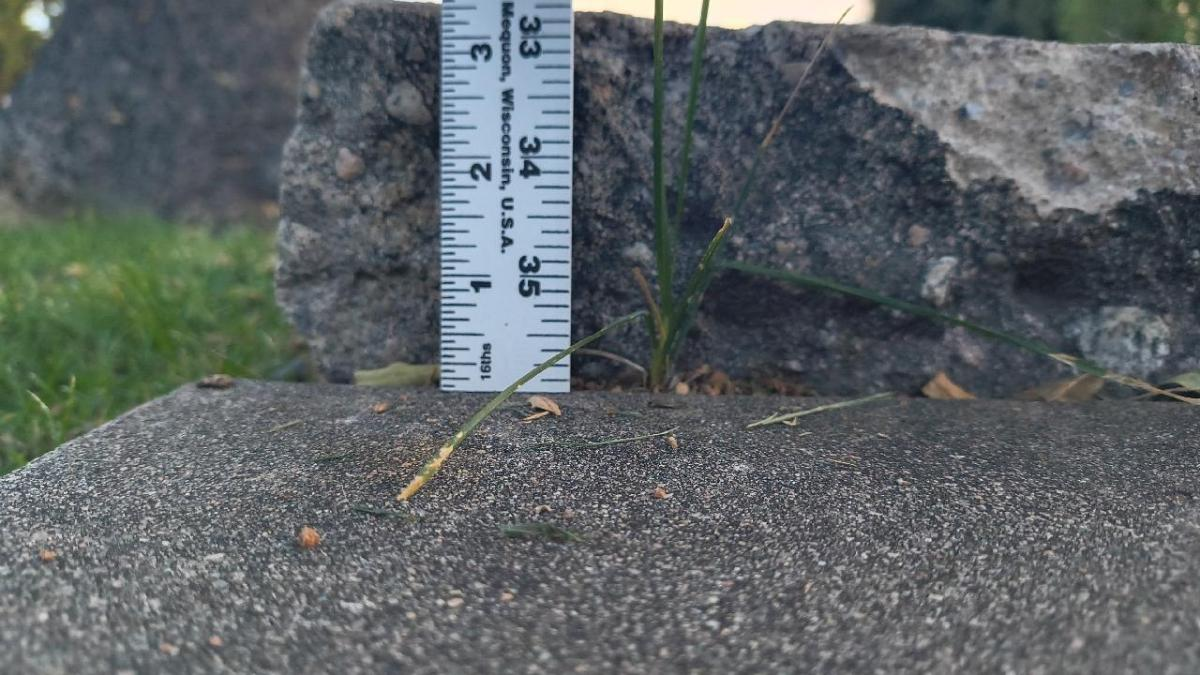
A vertical fault and a yardstick showing that its height exceeds 3 inches. A major tripping hazard and a serious violation of the Americans with Disabilities Act.
It was also extremely rewarding later to see that data visualized in the solution’s web maps created in Map Viewer and experiences built in ArcGIS Experience Builder. I took the liberty of changing the basemap to a dark theme, creating a stark backdrop for my brighter symbology colors. Check out my StoryMap (using ArcGIS StoryMaps), which provides an interactive map-based exploration of the data.
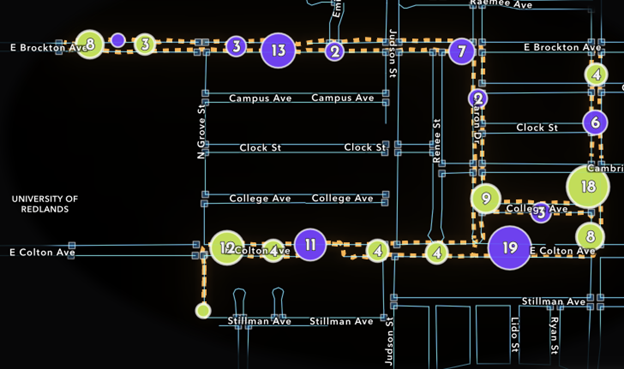
A map showing clusters of vertical faults in sidewalks in Redlands, classed according to whether the predominant apparent cause is tree roots (green) or unknown (purple).
Assessing the deep learning model was a fun but more intensive process. Since I was unable to obtain existing imagery meeting the model’s resolution requirements, I enthusiastically seized the opportunity to fly a drone (under supervision) to collect original imagery. It was a little nerve-racking—but only during take-off and landing; it flew on autopilot along a pre-planned route once it was up in the sky.
After a few rounds of processing, the deep learning model had translated the imagery I collected into sidewalk lines and curb ramp points. Comparing the results to the ground-truth data I had verified was insightful: with both precision and recall over 80%, the model did well identifying sidewalks. However, it performed relatively poorly at identifying curb ramps, making it clear that certain purposes are better suited for the application of geospatial AI than others.
Developing your own GIS independent study
Working on this project left me with a few key takeaways that I hope might help you, dear reader, should you be interested in doing an independent study while on your quest to become a GIS professional:
- Study something that matters to you and/or your community. Sidewalks matter because pedestrians, whether on foot or on wheels, deserve to be safe when using them. Think about what matters to you, your neighbors, and other people around you, and consider how GIS might be applied to solve a problem related to it or improve some aspect of it.
- Find out what’s already out there and what’s already been done. A few web searches of key terms led me to the Sidewalk Management solution, jump-starting my progress by allowing me to skip setup and move directly to collecting, visualizing, and analyzing data. From the academic literature I found, I understood the fundamentals of the sidewalk problem and recent academic attempts to apply GIS to begin solving it. Knowing the landscape and available tools will equip you to make the most of an independent study.
- Make a plan. I was successful in my independent study because I took the time to plan what I would do. My plan showed my department chair and the dean that I had thought through the process and knew the direction I was heading. Your study plan doesn’t have to be overly detailed; it just has to lay out the key steps that will get you to your goal.
- Try out multiple GIS products. I was fortunate to find the Sidewalk Management solution, as it enabled me to use multiple maps and apps across the ArcGIS product suite. I learned that GIS is not just maps but an ever-evolving, innovative technology that continues to advance our ability to understand and interpret the world across numerous frontiers Using more than one product will give you a great perspective on what’s possible with GIS.
- Take advantage of human resources. This project gave me the opportunity to reach out to important stakeholders and experts, including the GIS teams at the City of Redlands and San Bernardino County and the lead product engineer who developed the Sidewalk Management solution. They gave me further insight and guidance that I wouldn’t have gotten through my own research alone. I encourage you to use independent study to start building connections like these in the GIS community.
- Share your work. To communicate my findings, I developed a StoryMap (different from the one linked above) that detailed my research process. Later, I had the opportunity to share my StoryMap at the 2026 LA Geospatial Summit, where, to my great surprise, it earned the Most Innovative Use of Technology award. It never really crossed my mind when I was doing the work that I might get recognition for it, but it was gratifying to find out that my work had resonated with others in the field of GIS. Use mediums like StoryMap to start building your GIS portfolio and bring light to the great work that you do.
- Don’t be afraid! The idea of doing an independent study can be daunting, but you are just as capable as I am, whether you’re a graduate or undergraduate student. You could gain invaluable GIS experience that you might not otherwise get in your academic program.
From student to GIS professional
After completing my project, I was honored to be chosen as a 2026 Esri summer intern. I’m grateful to have continued my GIS learning over the past few months in my internship on the ArcGIS Pro Documentation team. I also took the PreGISP exam in May, earning the GISP-E credential. My experiences over the past year have really opened the door for me to become a GIS professional; I hope this blog inspires you to gain those experiences that will open the door for you, too.
Please feel free to connect with me on LinkedIn or reach out to me by email!





