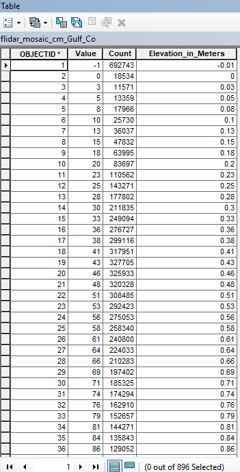
I have a Mosaic Lidar raster that I subset with just one counties elevations. They are in cm so I added an additional field to the attribute table and ran the field calculator to convert to m. Is there a way to make that new information my "Value" field? Is there a raster tool that would do this?
David, you mentioned that I could use the raster calculator to fix this problem. Could you help me with what the expression would look like if I want to change the VALUE field in my raster attribute table to meters instead of centimeter? It worked with changing the z value like you said but if I want to do any further statistics it would be better to have a different dataset(?) that has the corrected Values as meters. I hope this makes sense. I really do appreciate your help.
David, thank you. I changed the z value to .01 and I think this is a much more accurate representation of the slope within this county. I am just learning and I felt like my head would explode after a day or two. Thank you again. Off to see what holds me up next...lol.
Ok, I'll give it a try.
It's coming back with those values as it's currently equating metres on the ground with cm, making it appear like Mordor. You need to change the raster units to metres using raster calculator or you might be able to specify a z factor of 0.01
Thanks. I did manage to change the symbology of the table to show the meters instead which is a start. I tried running slope and used the VALUE field but I feel it doesn't come back with meaningful numbers. I just don't think there is as much slope over 50% in that county. It is flat even though there are a lot of dunes.
Use a tool called 'Raster Calculator' and multiply your current values by 0.01
https://desktop.arcgis.com/en/arcmap/10.3/tools/spatial-analyst-too…
No, you can't change the field name, but you can use the other field. What are you doing that you are stuck on the Value field?
Les membres connectés peuvent publier, suivre les mises à jour, et plus encore. Nouveau ici ? Inscrivez-vous gratuitement.
Find useful guides, FAQs, and documents to help you navigate and make the most of Esri Community.