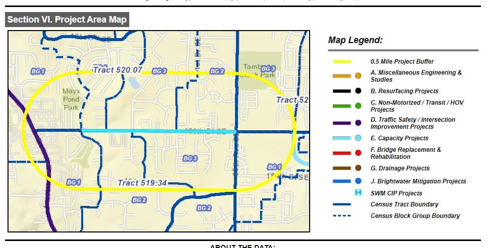
As I keep working on migrating my 3.X app to 4.X, I keep hitting issues. Now, it's print output. The same basic code block, adjusted for 4.X differences, produces a vastly different output. The final part of a custom report generating tool is to produce a JPEG map and insert it into a HTML report output. The output from 3.X produces this:
The 4.X API output results in this:
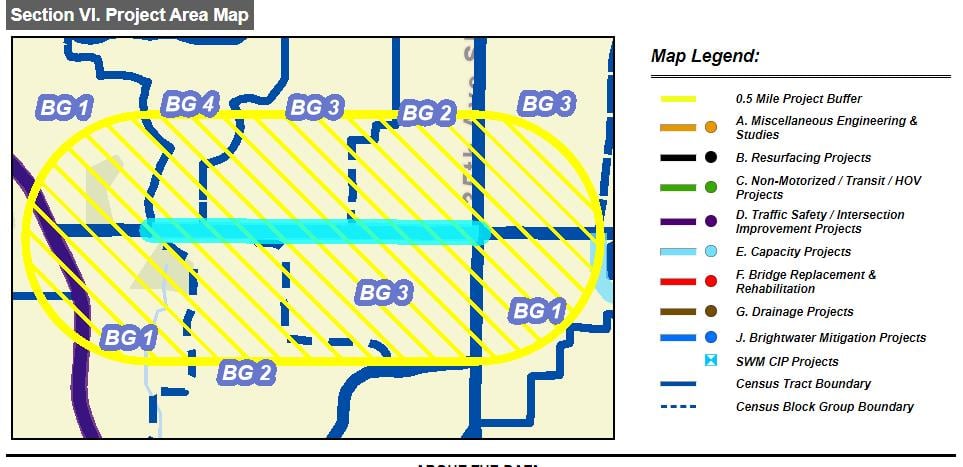
It's almost as if there's a "reference scale" setting that I haven't adjusted but, from looking over the API reference, I can't see any. Is there one? There really isn't much to the code side of things so I'm kinda flummoxed but this.
FWIW, the relevant 3.X code:
			tractsShown = theTractLayer.visible;
			bgsShown = theBlockgroupLayer.visible;

			//Switch the labelling class for Tracts/Block Groups temporarily for proper print sizes
			theTractLayer.setLabelingInfo([ app.tractPrintClass ]);
			theBlockgroupLayer.setLabelingInfo([ app.bgPrintClass ]);

			if (!tractsShown) {
				theTractLayer.setVisibility(true);
			}

			if (!bgsShown) {
				theBlockgroupLayer.setVisibility(true);
			}

			if (highlightGeom != null) {
				highlightSymbol = new SimpleFillSymbol(SimpleFillSymbol.STYLE_FORWARD_DIAGONAL,
				  new SimpleLineSymbol(SimpleLineSymbol.STYLE_SOLID,
				  new Color([255,255,0.1]), 4),new Color([255,255,0,0.1]));

				highlightGraphic = new Graphic(highlightGeom, highlightSymbol,null,null);
				app.map.graphics.add(highlightGraphic);

			}

			pTemplate = new PrintTemplate();
			pTemplate.exportOptions = {
				width: 600,
				height: 400,
				dpi: 150
			};
			pTemplate.format = "jpg";
			pTemplate.layout = "MAP_ONLY";
			pTemplate.preserveScale = false;
			pTemplate.showAttribution = false;

			var params = new PrintParameters();
			params.map = app.map;
            params.async = false;
			params.template = pTemplate;

			jpgMapDiv = theDocument.getElementById("jpegMap");

			thePrintTask = new PrintTask(url);
            window.setTimeout(function() {
                thePrintTask.execute(params, function(result) {
                    jpgMapDiv.innerHTML = "<img src=\"" + result.url + "\" style=\"border:2px solid black;left:25%\"\>";
                    var oldExtent = app.preRptExtent;
                    app.map.setExtent(curExtent);
					//Restore the screen-centric label sizes for Tracts/Block Groups
					theTractLayer.setLabelingInfo([ app.tractScreenClass ]);
					theBlockgroupLayer.setLabelingInfo([ app.bgScreenClass ]);

					if (highlightGeom != null) {
						app.map.graphics.remove(highlightGraphic);
						highlightGraphic = null;
						highlightGeometry = null;
					}
                }, function(err) {
                    //Print task failed
                    app.map.graphics.remove(highlightGraphic);
					theTractLayer.setLabelingInfo([ app.tractScreenClass ]);
					theBlockgroupLayer.setLabelingInfo([ app.bgScreenClass ]);
                    highlightGraphic = null;
                    highlightGeometry = null;
                });

                //Reset the current viewing status of the census tract / blockgroup layers
                if (!tractsShown) {
                    theTractLayer.setVisibility(false);
                }

                if (!bgsShown) {
                    theBlockgroupLayer.setVisibility(false);
                }
            },1000);
And the rewritten 4.X-
		var theTractLayer = app.map.findLayerById("censusTracts");
		var tractsShown = theTractLayer.visible;
		var theBlockgroupLayer = app.map.findLayerById("censusBlockGroups");
		var bgsShown = theBlockgroupLayer.visible;

		//Switch the labelling class for Tracts/Block Groups temporarily for proper print sizes
		theTractLayer.labelingInfo = [ app.tractPrintClass ];
		theBlockgroupLayer.labelingInfo = [ app.bgPrintClass ];

		if (!tractsShown) {
			theTractLayer.visible = true;
		}

		if (!bgsShown) {
			theBlockgroupLayer.visible = true;
		}

		if (app.highlightGeom != null) {
			var highlightSymbol = new SimpleFillSymbol({
				  color: new Color([255,255,0,1]),
				  outline: new SimpleLineSymbol({
					cap: "round",
					color: new Color([255,255,0,1]),
					join: "round",
					miterLimit: 1,
					style: "solid",
					width: 2
				  }),
				  style: "forward-diagonal"
			});

			var highlightGraphic = new Graphic({geometry: app.highlightGeom, symbol: highlightSymbol});
			app.theView.graphics.add(highlightGraphic);
		}

		var pTemplate = new PrintTemplate();
		pTemplate.exportOptions = {
			width: 600,
			height: 400,
			dpi: 300
		};
		pTemplate.format = "jpg";
		pTemplate.layout = "map-only";
		pTemplate.scalePreserved = false;
		pTemplate.attributionVisible = false;

		var params = new PrintParameters();
		params.view = app.theView;
		params.template = pTemplate;

		var jpgMapDiv = theDocument.getElementById("jpegMap");
		var oldExtent = app.preRptExtent;
		//app.theView.goTo(app.curExtent);

		print.execute(app.printUrl, params).then(function(printResult) {
			jpgMapDiv.innerHTML = "<img src=\"" + printResult.url + "\" style=\"border:2px solid black;left:25%\"\>";
			//Restore the screen-centric label sizes for Tracts/Block Groups
			theTractLayer.labelingInfo = [ app.tractScreenClass ];
			theBlockgroupLayer.labelingInfo = [ app.bgScreenClass ];

			if (app.highlightGeom != null) {
				app.theView.graphics.remove(highlightGraphic);
				highlightGraphic = null;
				app.highlightGeom = null;
				app.theView.goTo(oldExtent);
			}
		}).catch(function(printError) {
			//Print task failed
			app.theView.graphics.remove(highlightGraphic);
			theTractLayer.labelingInfo = [ app.tractScreenClass ];
			theBlockgroupLayer.labelingInfo = [ app.bgScreenClass ];
			highlightGraphic = null;
			app.highlightGeom = null;
			app.theView.goTo(oldExtent);
		});




