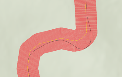
I'm trying to find a way to quantify the difference between two lines. Here's the situation; We have a GPS Track of a proposed road and Design line for that road from the contractor, and we want to find how far, on average, the GPS Track is from the design line. I've attached a picture here. The yellow line is the design line and the black one is the GPS track. The red buffer is a line buffer at 1-foot increments, and it's part of a method I used to find this answer but I'm just wondering if there's a more statistically sound way to answer this question.