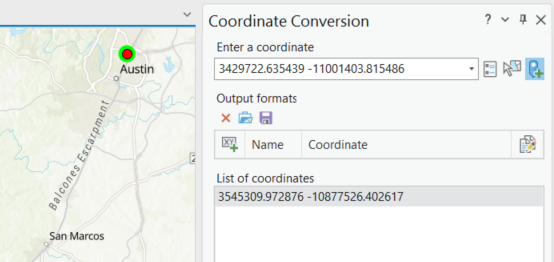
Hello, ...I don't think I'm understanding how the 'Coordinate Conversion' tool works; doesn't seem very intuitive. See below. So, I used the 'Map Point Tool' to click on a point. In the 'Enter a coordinate' box/List of coordinates box' -- where is it getting this coordinate system info? This is a New blank Map set to WGS84 Web Mercator auxiliary sphere. My Map Display coordinates are in Decimal Degrees.
Even so, I don't know what to do next in order to convert it to something else?
...The Help Doc didn't help, so any assistance is appreciated 😉 Thanks!