Completely stumped here. I have seen a handful of somewhat similar threads dealing with Lambert Azimuthal Equal Area...the problem here is working out the proper transformation. Here's a bit of a summary of what I do know.
- This (NDVI) data can be obtained from USGS here [AVHRR in this example].
- I have other data I am trying to align with this data (GCS_North_American_1983 WKID: 4269).
- There is no WKID associated with the data's projection info, nor is there a GCS or datum.
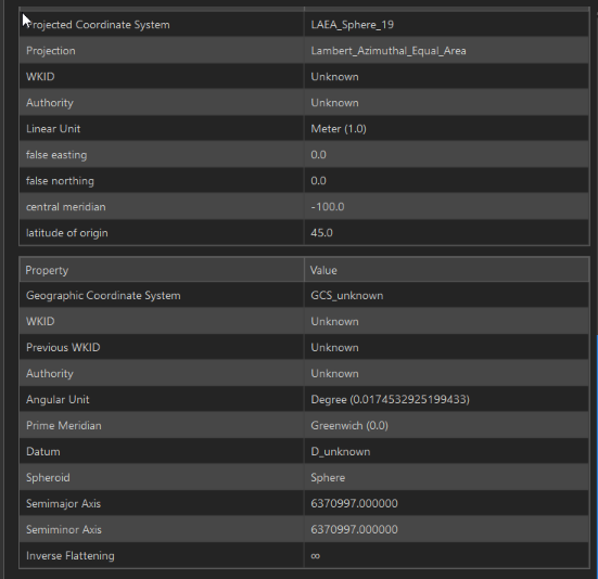
- When searching for 'LAEA_Sphere_19', surprisingly, only a handful of results are returned. One result provides some additional insight. Spatial Reference .org lists this as "SR-ORG Projection 8750 - eModis Phenology"
- The ESRI WKT reflects exactly what we see in the raster's spatial reference properties:
PROJCS["LAEA_Sphere_19",GEOGCS["GCS_unknown",DATUM["D_unknown",SPHEROID["Sphere",6370997,0]],PRIMEM["Greenwich",0],UNIT["Degree",0.017453292519943295]],PROJECTION["Lambert_Azimuthal_Equal_Area"],PARAMETER["latitude_of_origin",45],PARAMETER["central_meridian",-100],PARAMETER["false_easting",0],PARAMETER["false_northing",0],UNIT["Meter",1]]
- The raster metadata provides no additional insight.
- There is much discussion (and stories of headache) in dealing with the Sinusoidal projection associated with other USGS/NASA MODIS data, but this is not that projection. Out of desperation, I tried creating the custom geographic transformation found here...of course that failed to yield proper results. This was another dead-end waste of time.
- The various online tools associated with manipulating the USGS/NASA HDF files are not valid for this data. This are TIFs for NDVI Phenology.
- My source data is GCS_North_American_1983; i need to somehow match to this LAEA Sphere 19.
Please, any insight or help here would be most appreciated...I cannot believe how little documentation there is regarding this!

