Recently I encountered a problem on creating print service with "Export Web Map" server tool.
When Export Web Map shared as Geoprocessing Service, it accept a JSON to understand what it is going to export, here, I passed in a map service with labeled layer
<SPAN class="punctuation token">.</SPAN> <SPAN class="punctuation token">.</SPAN> <SPAN class="punctuation token">.</SPAN>
<SPAN class="punctuation token">{</SPAN>
<SPAN class="string token">"id"</SPAN><SPAN class="punctuation token">:</SPAN> <SPAN class="string token">"LayerWithLabel"</SPAN><SPAN class="punctuation token">,</SPAN>
<SPAN class="string token">"url"</SPAN><SPAN class="punctuation token">:</SPAN> <SPAN class="punctuation token">{</SPAN><SPAN class="punctuation token">{</SPAN>url<SPAN class="punctuation token">}</SPAN><SPAN class="punctuation token">}</SPAN><SPAN class="punctuation token">,</SPAN>
<SPAN class="string token">"title"</SPAN><SPAN class="punctuation token">:</SPAN> <SPAN class="string token">"{{title}}"</SPAN><SPAN class="punctuation token">,</SPAN>
<SPAN class="string token">"opacity"</SPAN><SPAN class="punctuation token">:</SPAN> <SPAN class="number token">0.5</SPAN><SPAN class="punctuation token">,</SPAN>
<SPAN class="string token">"visibility"</SPAN><SPAN class="punctuation token">:</SPAN> <SPAN class="keyword token">true</SPAN><SPAN class="punctuation token">,</SPAN>
<SPAN class="string token">"minScale"</SPAN><SPAN class="punctuation token">:</SPAN> <SPAN class="keyword token">null</SPAN><SPAN class="punctuation token">,</SPAN>
<SPAN class="string token">"maxScale"</SPAN><SPAN class="punctuation token">:</SPAN> <SPAN class="keyword token">null</SPAN><SPAN class="punctuation token">,</SPAN>
<SPAN class="string token">"visibleLayers"</SPAN><SPAN class="punctuation token">:</SPAN> <SPAN class="punctuation token">[</SPAN> <SPAN class="number token">0</SPAN> <SPAN class="punctuation token">]</SPAN><SPAN class="punctuation token">,</SPAN>
<SPAN class="string token">"layers"</SPAN><SPAN class="punctuation token">:</SPAN> <SPAN class="punctuation token">[</SPAN> <SPAN class="punctuation token">{</SPAN>
<SPAN class="string token">"id"</SPAN><SPAN class="punctuation token">:</SPAN> <SPAN class="number token">0</SPAN><SPAN class="punctuation token">,</SPAN>
<SPAN class="string token">"layerDefinition"</SPAN><SPAN class="punctuation token">:</SPAN> <SPAN class="punctuation token">{</SPAN>
<SPAN class="string token">"definitionExpression"</SPAN><SPAN class="punctuation token">:</SPAN> <SPAN class="punctuation token">{</SPAN><SPAN class="punctuation token">{</SPAN>definition string<SPAN class="punctuation token">}</SPAN><SPAN class="punctuation token">}</SPAN><SPAN class="punctuation token">,</SPAN>
<SPAN class="punctuation token">}</SPAN>
<SPAN class="punctuation token">}</SPAN> <SPAN class="punctuation token">]</SPAN>
<SPAN class="punctuation token">}</SPAN>
<SPAN class="punctuation token">.</SPAN> <SPAN class="punctuation token">.</SPAN> <SPAN class="punctuation token">.</SPAN><SPAN class="line-numbers-rows"><SPAN></SPAN><SPAN></SPAN><SPAN></SPAN><SPAN></SPAN><SPAN></SPAN><SPAN></SPAN><SPAN></SPAN><SPAN></SPAN><SPAN></SPAN><SPAN></SPAN><SPAN></SPAN><SPAN></SPAN><SPAN></SPAN><SPAN></SPAN><SPAN></SPAN><SPAN></SPAN><SPAN></SPAN><SPAN></SPAN></SPAN>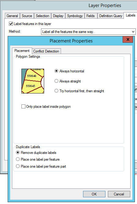
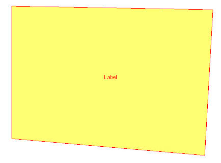
While this layer display as expected in our system with ArcGIS javascript api, It always got tiled-like duplicate labels in the Export Web Map result.
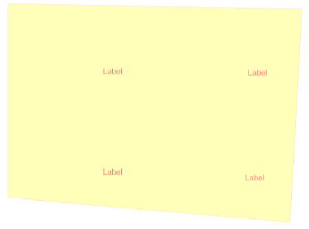
Are there any extra options in Export Web Map specification needed to remove the duplicate labels? Or is it a bug? I need something to reply to our clients.

