Hallo,
ArcGIS shows the size of each Dataset and I want to use this sizes in Python.
so the first point is I'm looking for a function that decribes the size of a featureclass inside my filegeodabase. ArcCatalog shows it in the Content.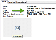
I've serched inside the Decribe-Objects, but didn't found. Did I overlooked something?
Second point is I'm looking for a function that describe wich files belongs for ArcGIS to a geodataset, so that i can summerize the sizes of each part.
For example the land.shp -Dataset consist of e.g SHP, SHX, DBF-File. So, initially glob.glob('land.*') seems to be the solution. But I've got also an archive land.zip or an Table land.csv inside the directory...
How can I consider geodata like ArcGIS do?
Thanks, Lothar



