I've geocoded around 25K addresses and I'd like to sort them into 2 buckets, high vs low precision. To me a high score is meaningless if it can only find it to the nearest postal centroid for instance.
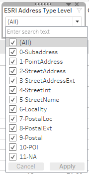
Currently I have ordered the address level results into the following numerical buckets. My goal is to quickly highlight & bucket addresses ESRI isn't as confident in (ex: IF Address-level > 6 then low precision match). As these represent customer addresses I felt (esp for L1) if ESRI can't get it to a street level I doubt we could even send anything to this address. So essentially this is helping us see bad addresses quickly.
Is this the right order they should be in? I wasn't sure if locality should be above postal, and I feel like POI could be higher. What is the right stank rank order these should be in, I couldn't find a definitive listing.
I've also viewed the following topics on this as well:
Also it was confusing to figure out where to put this question, is this the right place for it?


