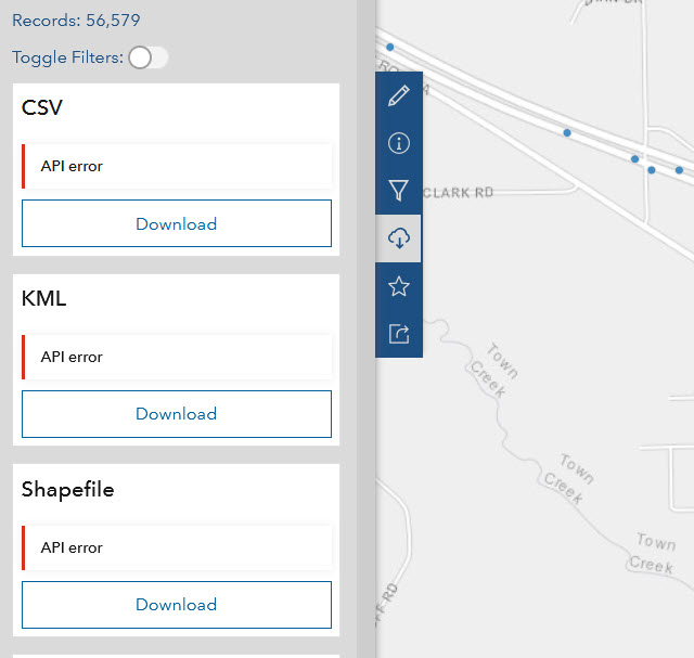
We started seeing and API error in the download section of our Open Data page. It looks like there are no reported issues on Esri's end https://status.arcgis.com/.
Has anyone seen this? Or do you know how to fix it? This is happening with all our content.
Thank you!
Tony
Hi @JosephBisig We understand that the "API Error" is generic and can be confusing. Have you enabled the "Local Projections" setting on the Hub site? Hub needs a numeric SRID and will throw an error when trying to query metadata without one. For example, on this item on Hub https://gisdata-piercecowa.opendata.arcgis.com/datasets/pierce-county-council-districts/explore the Hub API returns an error when trying to get metadata. On that item's service
the Spatial Reference is
I believe that you'll either need to make an adjustment to the service's spatial reference or disable local projections, which will serve results in EPSG 4326.
I'm having the same issue, Tony. I thought it might be a security thing for our agencies but the same issue occurs on my home computer.
Hi,
I have the same issu. I have already post for this problem this week but no reply.... 😪
https://community.esri.com/t5/arcgis-hub-questions/download-doesn-t-work-with-gallery/m-p/1065815#M4517
I also have the same issue with some of our private layers. The data is point-in-time so I'm resolving by uploading the layers to AGOL rather than point to AGS service.
@Tony_J_Van_Der_Wielen Were you able to figure out why this is happening? I just encountered this same exact problem today. I have 10+ other Hub sites and I have downloaded data from them without an issue today as well.
Check the projection of the layer and if it is different to the local projection then disable the local projection in your hub site data setting. Else republish with your local projection.
Esri said it was a problem on their end of things and have resolved the issue. They would not give me the details, but if this is not resloved, I would open a ticket with them.
We just starting having this problem today. Logged a case with tech support, there appear to be a bug attached to this issue (BUG-000141153). No resolution yet. When using the Chrome browser developer tools, the 2 main errors I get are a 404 (Not found error) when I load the dataset's main download page - the data is in the AGO and is shared with the open data site is visible on the web map and within ArcGIS Online. The second error is when the user goes to download the data, the API error shows on the download options and and additional 500 (Internal Server Error) populates.
After further researching and looking into the network traffic it seems that when the Hub is trying to GET the Request URL for the layers on our open data site, it is not "getting" the entire URL. The layer ID is dropped (e.g. instead of https://opendata.arcgis.com/api/v3/datasets/1bc60d61f55644dc9320624a8fbea521_0 being the Request URL our HUB site is trying to GET https://opendata.arcgis.com/api/v3/datasets/1bc60d61f55644dc9320624a8fbea521 )
Which creates the first resulting in the "404 Not Found" error. The additional error is a "500 Internal Server Error" when you click on the open data download icon and an API Error message instead of being able to download the data.
I have been able to test this with another Open Data site on which our GIS data is accessible. Our site gets the API error but on the other site I can download the same data from the same feature services without issue.
How does this get resolved?
I'm sorry to hear that you're having an issue with downloads. We're actively working on a bug fix where gallery cards are linking to the wrong dataset view. You may see that the dataset page will load, but downloads will not because it has the wrong layer information, as @MeghanLeavey pointed out. Meghan, can you provide a public URL for content on your Hub site that is having this issue?
Thanks for the additional information. Hub should be able to support numeric WKIDs like 27700. However, there may be a bug parsing the WKID that was supplied. We're investigating the issue right now. Can you please give a URL to an example item that is now working?
Hi @ThomasHervey1
Yes, our open data can be found here: https://gis-monmouthnj.opendata.arcgis.com/pages/open-data
Thanks @MeghanLeavey it looks like there is a routing bug from the gallery card. We're actively working on a fix and hope to release it as soon as possible.If you need immediate access to downloads you can update the URL and adjust the layer information. For example, the routing resolution for "Building Footprints" will route to https://gis-monmouthnj.opendata.arcgis.com/datasets/fec0b3d813174cdfb766134315120460/explore?layer=0You'll still see the view working correctly and downloads will work if you adjust by removing the query and adding "_0"https://gis-monmouthnj.opendata.arcgis.com/datasets/fec0b3d813174cdfb766134315120460_0/explore
This issue is also affecting us, but it is not universally an issue on all datasets. Below is one example.
https://data.bellevuewa.gov/datasets/cobgis::bellevue-permits/explore?layer=0&location=47.589609%2C-122.160741%2C12.97
It is not an issue across the board though. The issue may be isolated to specific hives such as EYzEZbDhXZjURPbP.
Is there an ETA on when this will be fixed? We have quite a few members of the public who are trying to access our open data and are getting this error. I can confirm that the API does work when following @ThomasHervey1 method of adding the _0/explore string to the end of the url.
Glad to see it is not just us.
We have verified that this is a bug and we are completing QA now. Will release it tomorrow mid-day EST during our normal weekly Hub release. Please stay tuned to the Hub changelog https://hub.arcgis.com/pages/changelogApologies again for the inconvenience and thank you for your patience.
Appreciate the response and look forward to seeing the resolution.
Thank you for all of your help!
We are still experiencing the issue. I do see in the changelog that it has been fixed; has it been pushed out yet or is there still some problem?
It cleared up for us, but we were also dropped the original feature service and rebuilt it from the ground up. Not a pleasant experience, but it let us get the issue resolved.
Sorry to see that you're still having an issue. Is this the site where you're having issues https://open-data-stancounty-gis.hub.arcgis.com/ ?I have reproduced the issue and I've marked a fix has high priority. In the meantime, I suggest that you try making those items private and then public again. Afterward you may need to remove the link and re-add them within the gallery cards.The problem comes from the fact that these those gallery cards link out to items referencing services that have multiple layers. The update is still tying to reference the original URL without knowledge that this is a layer. For example, if you click the Annexations gallery card link, you'll route to https://open-data-stancounty-gis.hub.arcgis.com/datasets/d32e342982c849839aa787a1ae513f15_8/explore?layer=8&location=37.546472%2C-120.968143%2C11.62instead users should be route to a slightly different URLhttps://open-data-stancounty-gis.hub.arcgis.com/datasets/d32e342982c849839aa787a1ae513f15_8/explore?location=37.546472%2C-120.968143%2C11.62
We recognize that these bugs are very impactful and that the routing is confusing. Near-term we are adding additional tests to ensure that routing changes do not affect downloads. Mid-term we have plans to simplify the routing logic and remove the confusing _:layerId portion of the URL.
Hi Tom,
Yes, that is the site we are having trouble with. I'll try making them private and then public; with respect to the gallery cards, this was generated via the dynamic gallery layout. I'm assuming that removing it and re-adding it would generate the URLs again so I'll also give that a shot as well. We do appreciate your help!
We seem to be in better shape - all but one of the layers corrected. I ran through the steps of changing sharing levels and removing and then re-adding to the gallery and the hub page but those steps didn't work. I'm going to wait until the next fix that was mentioned yesterday gets pushed through, but if there is no change by Friday morning, I think we are going to just have to remove it and set up that service again.
Same. First reported to us 2021-09-09. 1st stop was AGOL Health Dashboard . All green still green. We've opened our own case with Esri tech support.
We got past it by republishing the dataset.
Good to know there is another workaround. Not practicable for our enterprise. We have hundreds of services and over 30 publishers.
Hello again,
I apologize for the inconvenience. We have identified the issue and we're aiming to release a hotfix as soon as possible. Thank you for suggesting a work-around @John_Spence .For future reference, ArcGIS Hub has a service-level status page found at https://hubstatus.arcgis.com/
Hello,
I want to give an update on the status of this fix.We have found a solution but we need time to ensure that automated and manual testing is comprehensive and that no other gallery cards or header links regress. As a result, we will not be able to release the fix today, but we are aiming to release as soon as possible.When a fix has been released and verified on production, we will update hubstatus.arcgis.com
HelloWe have just released a follow-up fix. Please check to see if you're still seeing an API Error on your downloads when navigating to content via a header link or a gallery card.
We started noticing this on three of our recently published feature services. This is what we see on our Historic Election Precincts 2004.
We are seeing these API errors occur in two other feature classes as well -
https://gisdata-piercecowa.opendata.arcgis.com/datasets/pierce-county-council-districts/explore
https://gisdata-piercecowa.opendata.arcgis.com/datasets/historic-election-precincts-1992/explore
Has this issue popped up again for anyone else?
Thanks,
Joey
Hi Thomas!
These items now work on our Hub site. It did look like a projection issue that was solved by reloading the data into our map projects and republishing. Always appreciate the help Thomas!
From the looks of this, it seems like having standalone tables without spatial component aren't supported for hub download?
Hola, tengo el mismo error en ARCGIS ENTERPRISE 10.9. con un servicio FeatureAccess: Enabed y compartido como publico ¿Alguna idea?
Saludos,
Anibal
I captured Web traffic with the URLs of the open data-Hub and it took me to: Resource was not found, and it was showing a 404 error.Based on previous research I verified the item ID in ArcGIS Online and Spatial Reference, and it was 32145, so Spatial reference was not the issue.I reviewed the REST services for other layers in the same and they worked for downloading. I suggested republishing the dataset since apparently there is no gap in the Spatial Reference or Metadata, and also verifying the export data settings.
I am also hitting this issue on personal use account (which means I cannot call Esri Support).
@ThomasHervey1 I tried the following with no luck...
1) Recreated the gallery
2) Update the Hub site settings to allow for local projection
Here is my site if you want to test it out https://data-pjdohertymaps.opendata.arcgis.com/
Here is the dataset I am trying to make available via Open Data
Seems to be working fine Paul! Our site has been acting up quite a bit of late. Sometime it works and sometimes we get the API error. It is very inconsistent.
I have just discovered that one of my layers is having this issue as well: https://od-jcwvgis.opendata.arcgis.com/datasets/8d4df0b309944ccf8b72bf0d279a168b_1/explore?location=39.311372%2C-77.850154%2C11.50
None of my other layers seem to have this issue. I tried republishing the layer and that didn't fix the problem. Our layer is using the ESRI extent, so it's not a projection issue.Any suggestions?
We are encountering the same issue. This was our biggest release of the year - it worked fine yesterday when I previewed the data. Now on release day I get API errors on all forms of data CSV, GeoJSON, Shapefile and KML.
https://geoportal.statistics.gov.uk/datasets/ons::output-areas-december-2021-boundaries-full-clipped-ew-bfc/explore
I've raised a ticket with My Esri and see what they say?
Also, i have this issue with one of my shared layer in the Hub site.
We've just started to have this issue too. With a single layer in a map service that hosts multiple map layers. All other map layers from this service can be downloaded. https://gis-kingcounty.opendata.arcgis.com/datasets/kingcounty::zipcodes-for-king-county-and-surrounding-area-zipcode-area/explore?location=47.506014%2C-121.485100%2C9.66
My Hub site starting having this issue out of nowhere last week. Random layers display the error intermittently.
I saw this article posted by Esri: https://support.esri.com/en-us/knowledge-base/error-api-error-next-to-download-options-in-arcgis-hub-000026514 but our layers are not shared via distributed collaboration.
I also tried enabling local projects on the site but no dice. Are there any other causes to this issue @ThomasHervey1?
Also seeing the "API Error" on some of our datasets on our Open Data site, but not all of them, even though owners haven't been changed, these datasets are different sublayers out of the same ArcGIS Server services, etc. Developer Tools shows that for the erroring datasets, where the request is https://opendata.arcgis.com/api/v3/datasets/whateverhubidthisis/downloads?parameters=1234 the response is errors: message: "Not Found". (The previously mentioned https://od-jcwvgis.opendata.arcgis.com/datasets/8d4df0b309944ccf8b72bf0d279a168b_1/explore?location=39.311357%2C-77.850154%2C11.50 I see also has "Not Found" in Dev Tools for its download endpoint)
Taking a look at https://opendata.arcgis.com/api/v3/datasets, seems like that's where all Open Data datasets are, and at the very bottom it has a "last" page of https://opendata.arcgis.com/api/v3/datasets?page%5Bnumber%5D=1420043&page%5Bsize%5D=10 but going to that last page gets you a:
{"errors":[{"title":"Server Error","status":500,"message":"search_phase_execution_exception: [illegal_argument_exception] Reason: Result window is too large, from + size must be less than or equal to: [10000] but was [14200430]. See the scroll api for a more efficient way to request large data sets. This limit can be set by changing the [index.max_result_window] index level setting."}],"meta":{}}
With this in mind, I tried searching for my erroring datasets in https://hub.arcgis.com and as you can guess, they're not showing up; my download-OK datasets show up, but not the API error ones.
Esri: I think you can try increasing your [index.max_result_window] index level setting for the Open Data/ArcGIS Hub site to see if this fixes the API Errors that we're seeing? Worth a shot.
Can you provide a screenshot of where the local projections setting is? I can't locate it.
Los miembros registrados pueden publicar, seguir actualizaciones y más. ¿Nuevo aquí? Regístrate gratis.
Find useful guides, FAQs, and documents to help you navigate and make the most of Esri Community.