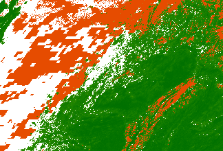
I'm trying to create a high resolution world map using by overlaying several landcover data sources. Currently I have four different data sources each at a 30m resolution. I have the data loaded into mosaic datasets and two of the layers are displaying with pyramids and work just fine. However, the other two layers don't display when zoomed out beyond a certain extent. I've tried building overviews, but they end up downsampling too much and look overly pixelated at the scale I need. Below is a quick screen grab of what it looks like, the resolution of the green layer, is how I also want the red to display.
Looking to either force the data to display with just pyramids regardless of scale, or to build overviews at a smaller cell size so it doesn't look as pixelated and blocky.