I have acquired DEM data provided in points, hard and soft breaklines from Altalis. It provides them as .gnp, .ghl, and .gsl files.
I have followed this thread for the answer AltaLIS DEM: how to load into arcGIS but I am facing the same issue as the last question poses.
The breakline data is organized as:
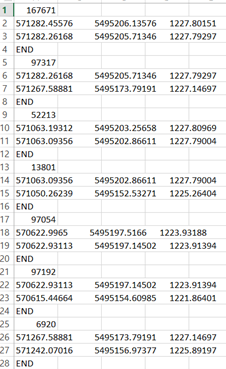
I understand what each element is but I am looking for a way to easily format into the 4 fields : Start X Field, Start Y Field, End X Field, End Y Field. Also what is the best way to interpolate a raster surface using both point and line data?
Thanks,
Jeremy

