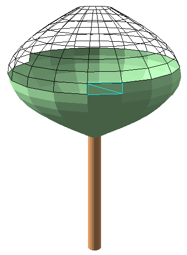
At this point I suppose you already read my posts on Working with 3D and M-aware geometries in Arcpy and Creating a 3D tree with Arcpy for 3D Analysis. The idea is to create a 3D tree using polygons. Something like the one below (which is only partially shown):
My first instinct was to take the code used to create the multipart polylines and divide these in parts and connect the parts from two sequential rings into a polygon. The first method I tried was to take the buffer outline and use the Polyline::positionAlongLine (value, {use_percentage}) method to pick the points on the lines. When using the same value these point should align on each ring. At least, that was what I thought. However, that was no success, leading to something very artistic, but little useful.
A very easy way of doing something similar is using the PointGeometry::pointFromAngleAndDistance (angle, distance, {method}). This yields a point based on an input point, an angle and a distance. Sweet!
The second challenge was changing the initial though of creating a multipart geometry, one for the trunk and one for the crown. This is no problem when you create a multipart polyline, but when you create a multipart polygon, it will apply some 2D topology rules to create the multipart polygon. This results in the loss of many polygon parts:

The third aspect you should bear in mind is that vertical polygons will not work in Arcpy. Hence the idea: https://community.esri.com/ideas/12289 . This can be easily avoided by letting the trunk decrease in diameter as it extends upwards and by avoiding an even number of crown_circles.
When you use an even number, you get this:
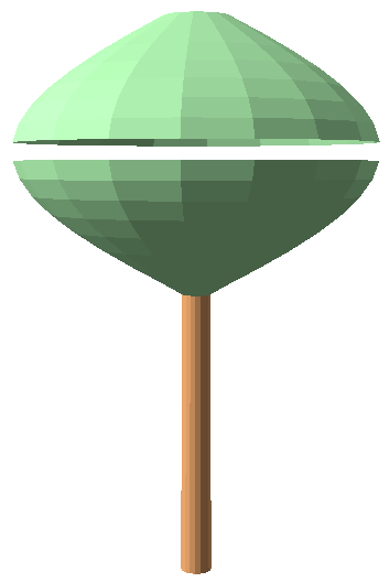
... a tree with a some kind of advanced ventilation implemented. 
So let's see what we can do to create the tree using polygons (not multipart) and throw in some python code:
import arcpy
import math

def main():
    import os

    # output
    fc_out = r'C:\GeoNet\_WorkingWith3D\data.gdb\TreePolygon3D_v01'
    arcpy.env.overwriteOutput = True

    # the tree point
    sr = arcpy.SpatialReference(3857)
    x = -13046027.327
    y = 4036381.962
    elevation = 365

    # dimensions of tree
    tree_height = 30
    crown_diameter = 16
    trunk_diameter = 0.7
    trunk_height = 15
    crown_height = tree_height - trunk_height

    # configuration of number of points and lines (detail of tree)
    crown_lines = 15  # number of lines for crown (avoid even numbers!)
    trunk_lines = 25 # number of lines for trunk
    pnts_on_circle = 18  # a point every 20 degrees on circle

    # create output featureclass
    ws, fc_name = os.path.split(fc_out)
    arcpy.CreateFeatureclass_management(ws, fc_name, "POLYGON", None, None, "ENABLED", sr)

    # Addional field for tree part to store Trunk or Crown
    fld_tree_part = "TreePart"
    arcpy.AddField_management(fc_out, fld_tree_part, "TEXT", None, None, 10)

    # insert cursor to write feature
    flds_out = ('SHAPE@', fld_tree_part)
    with arcpy.da.InsertCursor(fc_out, flds_out) as curs_out:

        # list to store multipart feature
        lst_feats = []
        pnt = arcpy.Point(x, y, elevation)
        pntg = arcpy.PointGeometry(pnt, sr, True)

        # define z values
        z0 = elevation
        z1 = z0 + trunk_height
        z2 = z1 + crown_height

        # create list of lists with points to create trunk polygons
        lst_polygons = createTrunk3Dv02(pntg, trunk_lines, pnts_on_circle, z0, z1 +1, trunk_diameter, sr)
        for lst_pol in lst_polygons:
            pol_trunk = arcpy.Polygon(arcpy.Array(lst_pol), sr, True, False)
            row_out = (pol_trunk, "Trunk", )
            curs_out.insertRow(row_out)

        # create list of lists with points to create crown polygons
        lst_polygons = createCrown3Dv02(pntg, crown_lines, pnts_on_circle, z1, z2, crown_diameter, sr)
        for lst_pol in lst_polygons:
            pol_trunk = arcpy.Polygon(arcpy.Array(lst_pol), sr, True, False)
            row_out = (pol_trunk, "Crown", )
            curs_out.insertRow(row_out)


def createTrunk3Dv02(pntg, trunk_lines, pnts_on_circle, z0, z1, trunk_diameter, sr):
    '''Create a list of lists where each inner list contains the 5 points
       to create a 3D polygon as part of the trunk'''

    lst_polygons = []
    for a in range(pnts_on_circle):
        # convert point on circle to angle 0 - 360 degrees
        angle1 = float(a) / float(pnts_on_circle) * 360
        angle2 = float(a + 1) / float(pnts_on_circle) * 360

        # create 2 points using first and second angle and trunk diameter
        pntga1d1 = pntg.pointFromAngleAndDistance(angle1, trunk_diameter, 'PLANAR')
        pntga2d1 = pntg.pointFromAngleAndDistance(angle2, trunk_diameter, 'PLANAR')

        # create 2 points using first and second angle and 90% of trunk diameter
        pntga1d2 = pntg.pointFromAngleAndDistance(angle1, trunk_diameter * 0.9, 'PLANAR')
        pntga2d2 = pntg.pointFromAngleAndDistance(angle2, trunk_diameter * 0.9, 'PLANAR')

        # make points z-aware
        pnta1d1 = arcpy.Point(pntga1d1.firstPoint.X, pntga1d1.firstPoint.Y, z0)
        pnta2d1 = arcpy.Point(pntga2d1.firstPoint.X, pntga2d1.firstPoint.Y, z0)
        pnta1d2 = arcpy.Point(pntga1d2.firstPoint.X, pntga1d2.firstPoint.Y, z1)
        pnta2d2 = arcpy.Point(pntga2d2.firstPoint.X, pntga2d2.firstPoint.Y, z1)

        # add 4 points + 1st point as list to polygon list
        lst_polygons.append([pnta1d1, pnta2d1, pnta2d2, pnta1d2, pnta1d1])

    # return list with lists of points to create polygons
    return lst_polygons


def createCrown3Dv02(pntg, crown_lines, pnts_on_circle, z1, z2, crown_diameter, sr):
    '''Create a list of lists where each inner list contains the 5 points
       to create a 3D polygon as part of the crown'''

    lst_polygons = []
    for n in range(crown_lines):
        # take pairs of rings (n and n+1)
        i1 = n
        i2 = n + 1

        # determine the elevation for each of the two rings
        zi1 = float(i1) / float(crown_lines) * (z2  - z1) + z1
        zi2 = float(i2) / float(crown_lines) * (z2  - z1) + z1

        # convert i1 and i2 to a value expressed in pi
        p1 = float(i1) / (crown_lines + 1) * math.pi
        p2 = float(i2) / (crown_lines + 1) * math.pi
        # calculate the diameter based on this value expressed in pi
        diam1 = math.sin(p1) * float(crown_diameter)
        diam2 = math.sin(p2) * float(crown_diameter)

        for a in range(pnts_on_circle):
            # determine the start and end angle for each pair of points on circle
            angle1 = float(a) / float(pnts_on_circle) * 360
            angle2 = float(a + 1) / float(pnts_on_circle) * 360

            # create 4 points, two on each ring
            pntga1d1 = pntg.pointFromAngleAndDistance(angle1, diam1 / 2.0, 'PLANAR')
            pntga2d1 = pntg.pointFromAngleAndDistance(angle2, diam1 / 2.0, 'PLANAR')
            pntga1d2 = pntg.pointFromAngleAndDistance(angle1, diam2 / 2.0, 'PLANAR')
            pntga2d2 = pntg.pointFromAngleAndDistance(angle2, diam2 / 2.0, 'PLANAR')

            # make points z-aware
            pnta1d1 = arcpy.Point(pntga1d1.firstPoint.X, pntga1d1.firstPoint.Y, zi1)
            pnta2d1 = arcpy.Point(pntga2d1.firstPoint.X, pntga2d1.firstPoint.Y, zi1)
            pnta1d2 = arcpy.Point(pntga1d2.firstPoint.X, pntga1d2.firstPoint.Y, zi2)
            pnta2d2 = arcpy.Point(pntga2d2.firstPoint.X, pntga2d2.firstPoint.Y, zi2)

            # add 4 points + 1st point as list to polygon list
            lst_polygons.append([pnta1d1, pnta2d1, pnta2d2, pnta1d2, pnta1d1])

    # return list with lists of points to create polygons
    return lst_polygons


if __name__ == '__main__':
main()If you have any questions about the code, just add a comment and I will get back to you.
Also have a look at the 3D City Base Layers - Add Trees topic of the 3D Cities section, there is a tool to create trees:
Add trees—3D Cities | ArcGIS for Desktop
Python python snippets 3D
