At the beginning of 2017, the competition "Mobility Innovation Competition @ Campus" (MICC) was announced by the Zentrum Digitalisierung Bayern. This competition was aimed at students of Bavarian colleges and universities. As part of participation, they were to engage with the topic of future mobility and develop a product idea that could be implemented within a startup.<\/P>
<\/P>
The competition was structured in three stages. First, a proposal had to be submitted describing the project idea, chosen methods, and a business plan. From the teams that submitted a proposal, about twenty were invited to an event at the end of April in Nuremberg. At this event, each team had three minutes to pitch their own idea. In total, 15 teams were admitted to the project phase. After that, they had three months to implement initial parts of their ideas. At a final event in July in Munich, the projects were presented and the winners awarded.<\/P>
<\/P>
 <\/P>
<\/P>
<\/P>
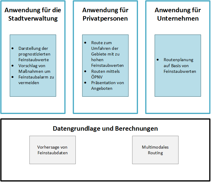
Linus Lambrecht and I, Simon Geigenberger, both study Master Geoinformatics at Universität Augsburg. We were made aware of the announcement and were immediately determined to participate. When searching for a suitable topic, we quickly came across the problem of high particulate matter values in German city centers and agreed that a driving ban on vehicles with combustion engines is not an adequate solution but that there must be a possibility to take measures dynamically and as needed. Our idea was to develop a platform called "Clean Routing." This is specifically aimed at large cities with particulate matter problems. Three components represent the central elements.<\/P>
<\/P>
 <\/P>
<\/P>
<\/P>
The primary and most important component is an application for city administrations, which provides a forecast for particulate matter values. The forecast values are calculated considering weather data using a model implemented in a Python script. This calculation is continuously optimized by a machine learning procedure. The current model delivers an accuracy of over 90 percent for cities located in our latitudes. The datasets used to train the model are from the spring months of this year. Since there is no data from winter months yet, the model can only be adjusted for these months after winter. This is necessary because particulate matter values develop differently at cold temperatures and snowfall than in other seasons. If an exceedance of the value set by the EU for a particulate matter alarm is predicted, then the city now has enough time early on to take measures to avoid exceeding the threshold value. Measures would be, for example, that endangered areas should be bypassed. <\/P>
<\/P>
Another application for private individuals is planned. This app calculates alternative routes based on particulate matter values that bypass endangered areas or directly switch to public transport (ÖPNV). Since private individuals should not be forced by bans to use public transport, this can be made attractive with various offers. These offers must be chosen by city administration and have an appealing effect on private individuals. Examples include reduced prices for ÖPNV tickets or the possibility to reserve a Park + Ride parking lot. Furthermore, users have the option to plan their trips and already include predicted particulate matter values and resulting exceedances of limit values in this planning.<\/P>
<\/P>
This planning service can also be integrated into a third application for companies, such as craft businesses or freight forwarders. These companies already know their routes in advance and can fit them into their work schedule so that areas are avoided during times when a particulate matter alarm is imminent. The city's measures are not strict bans but merely suggestions and guidelines. Therefore, it is necessary that besides the already mentioned offers for private individuals, there are further incentives that encourage traffic participants to use alternative routing.<\/P>
<\/P>
<\/P>
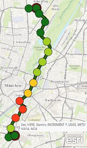 <\/EM><\/P>Original route with simulated particulate matter values<\/EM><\/P> <\/EM><\/P><\/TD> <\/EM><\/P>Original route with simulated particulate matter values<\/EM><\/P> <\/EM><\/P><\/TD>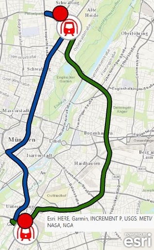 <\/P>Alternative route (green) and route with ÖPNV (blue)<\/EM><\/P> <\/EM><\/P><\/TD><\/TR><\/TBODY><\/TABLE> <\/EM><\/P> <\/P>So far, the technical components for forecasting particulate matter values and multimodal routing have been implemented. Thus, integration of the various components into a user interface is still missing in order to enter a test phase with the different applications. Since these are scripts, central data storage, and applications based on them with routing options, ArcGIS Online is excellently suited as a platform to bring together and technically implement these components. Whether and how we will further develop the product is still open since we are both in the final stretch of our studies. Nevertheless, the problem of high particulate matter values in German city centers still needs solving. We see our product as an optimal solution for this issue because no traffic participants are disadvantaged while still reducing the number of vehicles with combustion engines in cities.<\/P><\/P>Unfortunately, we could not place ourselves among the prize-winning ranks with this project. Still, we look back positively on participating in the competition. It was a very interesting experience because many disciplines were required and everything learned during studies could be combined. It was very exciting and instructive for us to develop from an idea to a product and its associated business plan.<\/P> <\/P>If you have further questions about our project, we are happy to assist:<\/P> <\/P>Simon Geigenberger: simon@geigenberger.info<\/P>Linus Lambrecht: linus.lambrecht@gmx.de <\/P>Alternative route (green) and route with ÖPNV (blue)<\/EM><\/P> <\/EM><\/P><\/TD><\/TR><\/TBODY><\/TABLE> <\/EM><\/P> <\/P>So far, the technical components for forecasting particulate matter values and multimodal routing have been implemented. Thus, integration of the various components into a user interface is still missing in order to enter a test phase with the different applications. Since these are scripts, central data storage, and applications based on them with routing options, ArcGIS Online is excellently suited as a platform to bring together and technically implement these components. Whether and how we will further develop the product is still open since we are both in the final stretch of our studies. Nevertheless, the problem of high particulate matter values in German city centers still needs solving. We see our product as an optimal solution for this issue because no traffic participants are disadvantaged while still reducing the number of vehicles with combustion engines in cities.<\/P><\/P>Unfortunately, we could not place ourselves among the prize-winning ranks with this project. Still, we look back positively on participating in the competition. It was a very interesting experience because many disciplines were required and everything learned during studies could be combined. It was very exciting and instructive for us to develop from an idea to a product and its associated business plan.<\/P> <\/P>If you have further questions about our project, we are happy to assist:<\/P> <\/P>Simon Geigenberger: simon@geigenberger.info<\/P>Linus Lambrecht: linus.lambrecht@gmx.de
|
