The Points of Interest layers
With this blog, it is already the last day of our OpenStreetMap three-day event with today information about our new OSM Points of Interest layers, also known as POI layers. These feature services contain interesting locations as recorded in OSM. You can think of, for example, shops or ATMs. I would like to tell you more about this here.
We have published a total of twelve new map layers and corresponding web maps in ArcGIS Online and these POIs are available both as separate layers and in one combined layer:
In the combined layer, you will find all objects from the other items, with corresponding styling. As attributes, we have included some basic characteristics such as name, opening hours, etc. The individual layers have more extensive attributes, depending on their subject.
Keys and attributes
Most of you will be used to working with vectors with a geographic location (whether that is a point, line, or polygon) and associated attributes in table form. OpenStreetMap works a bit differently and I would like to explain how we made that translation. OSM uses so-called keys. These are pieces of information added to an object. This can be, for example, shop=clothes. That means the object is a shop specified as clothing. But it is also possible to have shop=yes. That means there is a shop present but does not specify what kind of shop. In principle, each object can have an unlimited number of keys and no key is mandatory. On the OSM Wikipedia page, keys per topic are recommended. There is also a convention such as using certain (always English) terms. More information about the keys in OSM can be found here.
We based queries on these keys. For the Shops layer, for example, we wanted all objects that had a key shop=*, while the Leisure layer contains a combined query of certain keys with amenity=*, leisure=*, and tourism=*. With this, we determined which objects should be included in which layers. In the combined Points of Interest layer, you can find per object on which key the object is based and in which separate layer it is included.
For the attributes, we used the same system. In combination with the keys recommended per topic by the OpenStreetMap usage information and the keys we often saw in the data ourselves, we arrived at a number of attributes per topic.
Contributing to OpenStreetMap yourself
After determining and publishing the content of the layers, we also spent time formatting the pop-ups in ArcGIS Online. We found it important to make a direct link to OpenStreetMap itself. OSM is created by the community and therefore it is important to maintain that. In the pop-up, we included two links that directly open the page of the object in OpenStreetMap. This makes it possible not only to view the object in OpenStreetMap but also to immediately make changes with the second link.
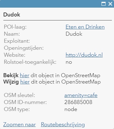
OpenStreetMap is entirely filled and managed by users and it is always possible to contribute yourself there. If you are interested in this, you can create an account on this page. With an account, it is possible via our pop-ups to go directly to the edit page of an object to modify it or of course to draw new objects. The POI layers are updated daily so that you will see any improvements back in these map layers the next day already. Eventually, these changes will also be visible in the base map. More information about contributing to OSM can be found here in Dutch; the original page in English can be found here.
The Points of Interest map layers are currently still in beta. This means that the structure of the map layers may still be adjusted. We welcome feedback via a message below or directly via content@esri.nl.
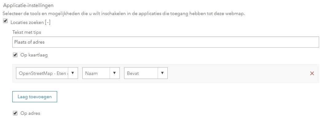
This brings us to the end of our trilogy, in which we told you about the three OpenStreetMap products we introduced. But this is certainly not the end of our OSM offering. An example of our future plans is that we want to use the locations now made available in these POI layers as a basis for a search function in the map. Until then, it is possible to set this up yourself in your web map by configuring that searching on the map layer is enabled. See the image below for settings.
Enjoy this new data and happy holidays in advance!
