Hi All,
I have several geodatabases that have geometries with Measures on them, i.e. a PolyLine with XYZ & M on each vertex. These can easy be displayed on a map by their XY coordinate.
However I'd like to be able to "straighten" these into a line to show route event data points at the measures, but I don't care about the XY location, sort of like a subway map.
Something like this:
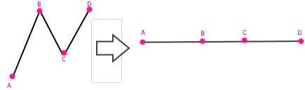
Does anyone have any suggestions of where to start? I was thinking of maybe a custom layer or custom projection/transformation, to somehow display the M data as the X coordinate, with a fixed Y? (without creating new features classes)
Thanks


