Hi everyone,
I am working with an Esri Utility Network for a gas distribution system and I have a specific question regarding the best practice for handling gas measurement points (PM) - (or interconnection or interception points) - and valves as subnetwork controllers.
In our current system (geometric network), districts are defined by these three objects:
- valves
- measurement points
- interconnection or interception points
Here is a simplified illustration of the scenario:
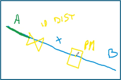
The green line represents District A .
The blue line represents District B
The valve (depicted as a butterfly symbol) is located on the boundary between District A and District B.
The measurement point (PM) is very close to the valve (about 1 meter apart) and belong to District B.
If we configure both the valve and the PM as subnetwork controllers, this will causes issues with the subnetwork validation because the middle pipe (X) that in real is form district B would be defined ad a new mini district.
My doubts and questions are:
Is it recommended to use only valves as subnetwork controllers and treat measurement points (PM) as regular assets logically connected to valves? In which fcl/asset group/asset type is better to put the PM them? which rules we can use (junction-edge or put the measurement point away from the pipeline)?
- Is it recommended to use only valves as subnetwork controllers with an attribute that identify that are used also as PM?
Alternatively, is there a best practice to model measurement points and valves both as subnetwork controllers when they are so close and belong to the same district?
How have other utility network implementations handled this kind of situation?
Are there specific subnetwork rules or configurations that can prevent validation errors in this case?
Thanks in advance for any advice or examples!
Astrid




