Hi there,
Having problems with getting spatial data out of an Oracle 19c database.
Reading the data in with the Check Geometry tool outputs the following errors;
Start Time: 29 July 2025 15:24:48
ERROR 999999: Something unexpected caused the tool to fail. Contact Esri Technical Support (http://esriurl.com/support) to Report a Bug, and refer to the error help for potential solutions or workarounds.
Wrong column type [Wrong column type]
Failed to execute (CheckGeometry).
Failed at 29 July 2025 15:25:14 (Elapsed Time: 26.41 seconds)
Trying to follow another report from the forums lead to a dead end Wrong Column Type
The questions asked by @VinceAngelo in that thread I've answered here:
Specific version Oracle: 19.27.0
Version ArcGIS Pro: 3.2.4
It is an enterprise geodatabase
How did we build the index:
  CREATE INDEX "BLK"."GDW_BLK_INV_RD_IDX" ON "BLK"."GDW_BLK_INV_RD" ("GEOMETRY")
   INDEXTYPE IS "MDSYS"."SPATIAL_INDEX" ;
How did we populate the metadata
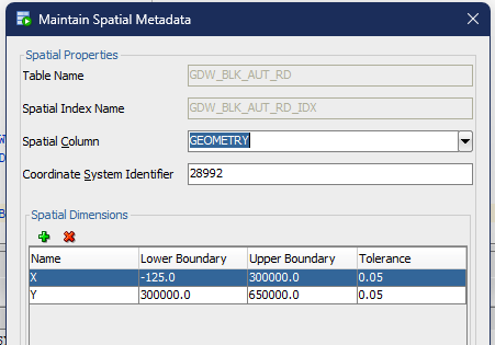
insert into user_sdo_geom_metadata
using select 'GDW_BLK_AUT_VW', column_name, diminfo, srid
from all_sdo_geom_metadata
where owner = 'DINO_DBA' and table_name = 'GDW_BLK_AUT_RD';
Output of DESCRIBE for this table gives:
Name Null? Type
------------- -------- ------------------
AUTHORITY_DBK NOT NULL NUMBER(38)
AUTHORITY_CD VARCHAR2(100)
AUTHORITY_NM VARCHAR2(100)
WEBSITE_BLN VARCHAR2(1)
DOSSIER_BLN VARCHAR2(1)
DISPLAY_CD VARCHAR2(2)
WEBSITE_URL VARCHAR2(255)
GEOMETRY MDSYS.SDO_GEOMETRY
what column did you select as the rowid: error is in the Check Geometry function, not possible to specify a rowid, but this is in the layer declared as AUTHORITY_DBK


