Hi all,
Relatively new to Arc Hydro and water resources as a subject area - apologies if the answer to this question should be obvious, but I have gone beyond scratching the surface at this point and have not found what I am looking for.
I am working on updating a layer of creek channels for a small city with relatively dramatic elevation gradients. The source layer they have currently was digitized in the 90s, and has some significant inaccuracies. Working from a current Lidar-derived DEM, I have used Arc Pro's Hydrology toolset to get Flow Direction, Flow Accumulation, and create stream channels. My goal is to develop an accurate stream channel layer suitable for watershed analysis across different stream order scales.
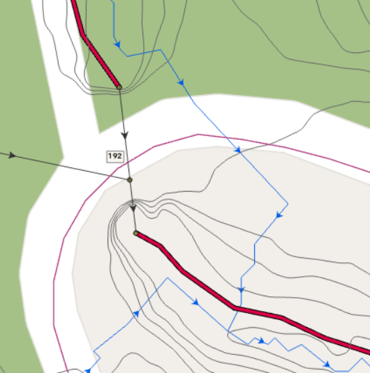
In undeveloped areas, the DEM-derived channels are clearly more accurate than the older layer - however, near infrastructure, developed areas, and urban areas, the DEM-derived channels start to behave strangely. Based on a visual inspection, many of the "strange" channel behaviors are in areas where MS4 infrastructure routes the water under the surface before releasing it back into surface channels on the other side of the obstruction (i.e. road, etc.).
I am wondering if it is possible to use the Arc Hydro toolset (or anything else that would work!) to "inform" the DEM-based stream derivation processing about the MS4 infrastructure - for example, to "link" the inlet and outlet nodes on either end of a storm drain pipe such that Flow Accumulation would add the total accumulated value in the cell under the inlet to the cell under the outlet, and Flow Direction would recognize the storm drain pipe as flow a channel thus preserving actual down-gradient flow without auto-filling, wandering over the road, and sometimes maybe finding its way back to the actual channel.
See attached image for old stream layer (bold, red), storm drain nodes and pipes (green dots/black lines respectively), and newly derived channels (blue) doing crazy auto-sink-fill stuff to maintain connectivity.
Based on my current (limited!) understanding of the Arc Hydro tools, they work in the opposite direction of what I'm asking - i.e., you need accurate channels to start with before you can integrate them with storm drain infrastructure. I'm also as yet unsure whether, even when fully integrated, flow is actually "piped" through the storm drain system with respect to inlets and outlets. I am considering trying to "burn" the storm drain pipes into the DEM to achieve a similar effect, but this strikes me as potentially bad practice so I am looking for more information on other methods (or, if this idea is as clever as I thought it was when it first occurred to me, please let me know and you'll make my day).
Any suggestions, resources, examples, etc. that can help me conceptualize a solution to this problem are welcome! Thanks in advance for any assistance.
PS - On a related note: I am planning to erase the new streams by a roads layer wherever streams pass under roads - when I erase the newly derived streams by the road area, does this disrupt my "downstream" (haha) ability to use the stream end nodes as pour points for watershed analysis? Haven't thought this far ahead, deeply grateful for any thoughts!