I'm working on an app with a few feature layers. There are points (attractions) and polygons (preserves). Why do the polygons overlap the points? Image:
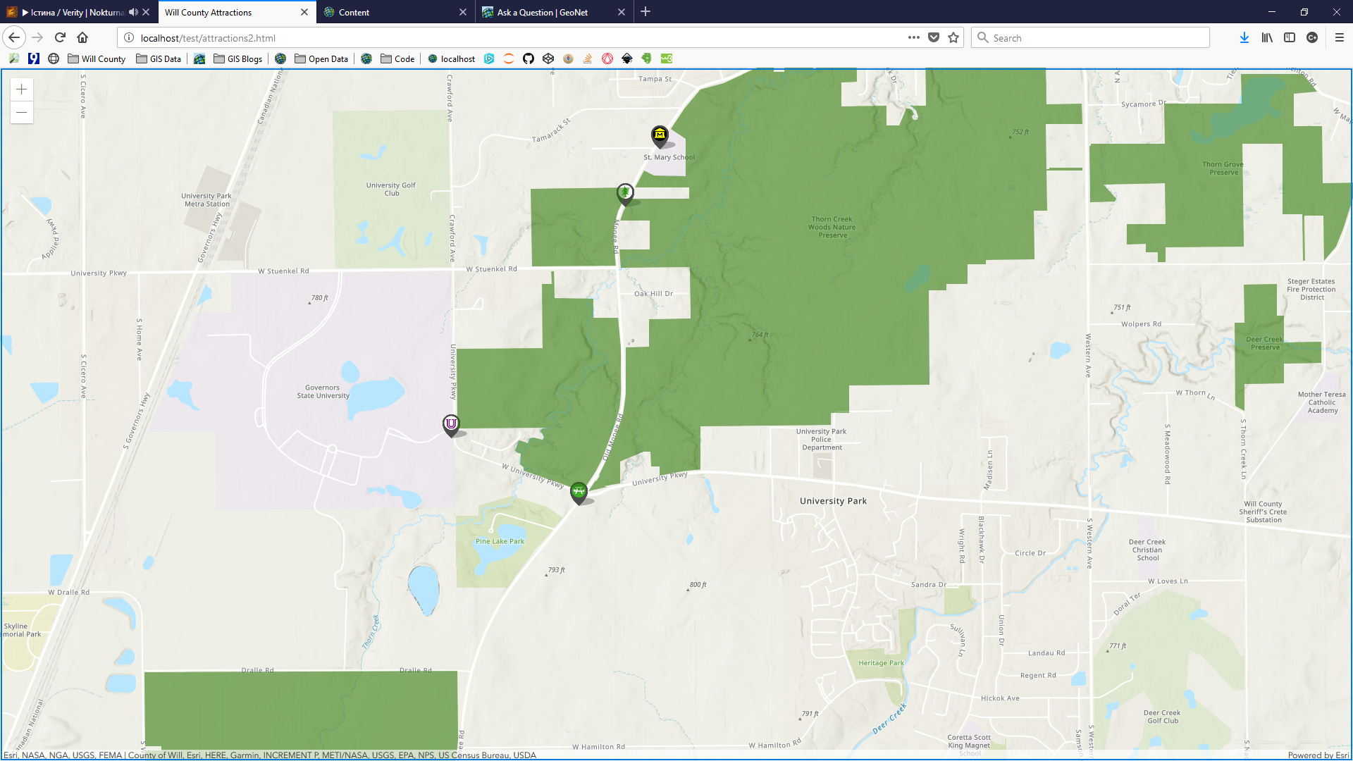
It doesn't seem to deal with the order of the feature layers in the <script>:
<SPAN class="comment token">//add attraction feature layer</SPAN>
<SPAN class="keyword token">var</SPAN> attractions <SPAN class="operator token">=</SPAN> <SPAN class="keyword token">new</SPAN> <SPAN class="token class-name">FeatureLayer</SPAN><SPAN class="punctuation token">(</SPAN><SPAN class="punctuation token">{</SPAN>
url<SPAN class="punctuation token">:</SPAN> <SPAN class="string token"><SPAN>"</SPAN><A class="jive-link-external-small" href="https://community.esri.com/external-link.jspa?url=https%3A%2F%2Fservices.arcgis.com%2FfGsbyIOAuxHnF97m%2Farcgis%2Frest%2Fservices%2FAttractions%2FFeatureServer%2F0%3Ftoken%3DFRQ3ta_CoBnz3s5xOY8Q649k62CGCo1FxjRhLn9ptI2ANN03ld5Yma2vHGf8MbovDnGjE6VxpTJ7kAShDHjSAeJiuFhGiZVTT1yC6oogNPkfeKqroE1drY-84jmqnKHcEtgY_WjYeIa-RAftHdlO-OgqDvMQSwElQzVkI_GjsXViudg4DHApFmxlp3RoYngYH5kYH3qXcVSAU6Qhp-DgciW_ZvfWalpE1IJsB2b6eKO1bdGdPibKtQUJoGuqFbs_" target="_blank">https://services.arcgis.com/fGsbyIOAuxHnF97m/arcgis/rest/services/Attractions/FeatureServer/0?token=FRQ3ta_CoBnz3s5xOY8Q649k62CGCo1FxjRhLn9ptI2ANN03ld5Yma2vHGf8MbovDnGjE6VxpTJ7kAShDHjSAeJiuFhGiZVTT1yC6oogNPkfeKqroE1drY-84jmqnKHcEtgY_WjYeIa-RAftHdlO-OgqDvMQSwElQzVkI_GjsXViudg4DHApFmxlp3RoYngYH5kYH3qXcVSAU6Qhp-DgciW_ZvfWalpE1IJsB2b6eKO1bdGdPibKtQUJoGuqFbs_</A><SPAN>"</SPAN></SPAN><SPAN class="punctuation token">,</SPAN>
id<SPAN class="punctuation token">:</SPAN> <SPAN class="string token">"attractions"</SPAN><SPAN class="punctuation token">,</SPAN>
zoom<SPAN class="punctuation token">:</SPAN> <SPAN class="number token">2</SPAN><SPAN class="punctuation token">,</SPAN>
<SPAN class="punctuation token">}</SPAN><SPAN class="punctuation token">)</SPAN><SPAN class="punctuation token">;</SPAN>
<SPAN class="comment token">//add will county boundary</SPAN>
<SPAN class="keyword token">var</SPAN> boundary <SPAN class="operator token">=</SPAN> <SPAN class="keyword token">new</SPAN> <SPAN class="token class-name">FeatureLayer</SPAN><SPAN class="punctuation token">(</SPAN><SPAN class="punctuation token">{</SPAN>
url<SPAN class="punctuation token">:</SPAN> <SPAN class="string token"><SPAN>"</SPAN><A class="jive-link-external-small" href="https://community.esri.com/external-link.jspa?url=http%3A%2F%2Fservices.arcgis.com%2FfGsbyIOAuxHnF97m%2Farcgis%2Frest%2Fservices%2FWill_County_Boundary%2FFeatureServer%2F0%3Ftoken%3D6vBDftNXDqbaZH6fbfhuDCeGkJFaWMSEPaeYDt6PbDBfVacnSMMD7PZS3QeCW6mDqgSFMK0tRjMyJyrxDPQ3rcjTNUCFpi0pfpU_mFLoKXGlT5FTGTPH3GjMqL9iQCqh9_ihX8D1-DQ5N_ptC-ic9bKeDLjqU2xQOv8wIRPjX5VwrtsQz_ltdanO49SVPaJ8F7EN6qWZMgvFw9V0iBbV4Iu0khjfjhuswBNzhjJa3I6q0epaze9AsPRVvVXJ5wik" target="_blank">http://services.arcgis.com/fGsbyIOAuxHnF97m/arcgis/rest/services/Will_County_Boundary/FeatureServer/0?token=6vBDftNXDqbaZH6fbfhuDCeGkJFaWMSEPaeYDt6PbDBfVacnSMMD7PZS3QeCW6mDqgSFMK0tRjMyJyrxDPQ3rcjTNUCFpi0pfpU_mFLoKXGlT5FTGTPH3GjMqL9iQCqh9_ihX8D1-DQ5N_ptC-ic9bKeDLjqU2xQOv8wIRPjX5VwrtsQz_ltdanO49SVPaJ8F7EN6qWZMgvFw9V0iBbV4Iu0khjfjhuswBNzhjJa3I6q0epaze9AsPRVvVXJ5wik</A><SPAN>"</SPAN></SPAN><SPAN class="punctuation token">,</SPAN>
id<SPAN class="punctuation token">:</SPAN> <SPAN class="string token">"boundary"</SPAN><SPAN class="punctuation token">,</SPAN>
zoom<SPAN class="punctuation token">:</SPAN> <SPAN class="number token">1</SPAN><SPAN class="punctuation token">,</SPAN>
<SPAN class="punctuation token">}</SPAN><SPAN class="punctuation token">)</SPAN><SPAN class="punctuation token">;</SPAN>
<SPAN class="comment token">//add Rt 66</SPAN>
<SPAN class="keyword token">var</SPAN> rt66 <SPAN class="operator token">=</SPAN> <SPAN class="keyword token">new</SPAN> <SPAN class="token class-name">FeatureLayer</SPAN><SPAN class="punctuation token">(</SPAN><SPAN class="punctuation token">{</SPAN>
url<SPAN class="punctuation token">:</SPAN> <SPAN class="string token"><SPAN>"</SPAN><A class="jive-link-external-small" href="https://community.esri.com/external-link.jspa?url=https%3A%2F%2Fservices.arcgis.com%2FfGsbyIOAuxHnF97m%2Farcgis%2Frest%2Fservices%2FWill_County_Tourist_Attractions%2FFeatureServer%2F1%3Ftoken%3DBj40q7dvc09lhoMxvDc_YHICLyf8Sz-HYSQ-n4lP4f4CGm3JaITUY0Tm7FnhhXcDel7W4rzUoKt1jDqw5CZGaEAQgq3IfUGez171nOzq5UlHAX5xQqWiV5BC3eUbd02xjimDX7VzJh8Z6muNPIep3iy1uZKfURjQ-Pdi5bbuF1p2DtffTsnOYCpNsyRX8SraieLTqxpm-2L6TdzRrUt2B6V48kzXcrQQz6uGDiUrBycc0GL0K94QiUmKwJNUxDXB" target="_blank">https://services.arcgis.com/fGsbyIOAuxHnF97m/arcgis/rest/services/Will_County_Tourist_Attractions/FeatureServer/1?token=Bj40q7dvc09lhoMxvDc_YHICLyf8Sz-HYSQ-n4lP4f4CGm3JaITUY0Tm7FnhhXcDel7W4rzUoKt1jDqw5CZGaEAQgq3IfUGez171nOzq5UlHAX5xQqWiV5BC3eUbd02xjimDX7VzJh8Z6muNPIep3iy1uZKfURjQ-Pdi5bbuF1p2DtffTsnOYCpNsyRX8SraieLTqxpm-2L6TdzRrUt2B6V48kzXcrQQz6uGDiUrBycc0GL0K94QiUmKwJNUxDXB</A><SPAN>"</SPAN></SPAN><SPAN class="punctuation token">,</SPAN>
id<SPAN class="punctuation token">:</SPAN> <SPAN class="string token">"rt66"</SPAN><SPAN class="punctuation token">,</SPAN>
zoom<SPAN class="punctuation token">:</SPAN> <SPAN class="number token">1</SPAN><SPAN class="punctuation token">,</SPAN>
<SPAN class="punctuation token">}</SPAN><SPAN class="punctuation token">)</SPAN><SPAN class="punctuation token">;</SPAN>
<SPAN class="comment token">//add Canal</SPAN>
<SPAN class="keyword token">var</SPAN> canal <SPAN class="operator token">=</SPAN> <SPAN class="keyword token">new</SPAN> <SPAN class="token class-name">FeatureLayer</SPAN><SPAN class="punctuation token">(</SPAN><SPAN class="punctuation token">{</SPAN>
url<SPAN class="punctuation token">:</SPAN> <SPAN class="string token"><SPAN>"</SPAN><A class="jive-link-external-small" href="https://community.esri.com/external-link.jspa?url=https%3A%2F%2Fservices.arcgis.com%2FfGsbyIOAuxHnF97m%2Farcgis%2Frest%2Fservices%2FWill_County_Tourist_Attractions%2FFeatureServer%2F7%3Ftoken%3DhhHLfbTFMO4xFbknwKCPflTqPD9RL5itP3d986PoOep4vUpYx5a27DnJ2PlFrPNXbkh_ytENT0SON4tQmlnxh7kiIqS10xkmfylm7IjTE9g5zah3TAe3XNEV6PxrN2jyU42SX0CF-7EABZGhODoFvu9K8wMQnAH5-2iJ26SmD68z2De_aXWT8EOjwAt6jBPV_BF9P031hxa8ei_rYDM126rHh_B7lPwoD8WjuVTp67qZyo3EdCKcuv1fsKG7g70M" target="_blank">https://services.arcgis.com/fGsbyIOAuxHnF97m/arcgis/rest/services/Will_County_Tourist_Attractions/FeatureServer/7?token=hhHLfbTFMO4xFbknwKCPflTqPD9RL5itP3d986PoOep4vUpYx5a27DnJ2PlFrPNXbkh_ytENT0SON4tQmlnxh7kiIqS10xkmfylm7IjTE9g5zah3TAe3XNEV6PxrN2jyU42SX0CF-7EABZGhODoFvu9K8wMQnAH5-2iJ26SmD68z2De_aXWT8EOjwAt6jBPV_BF9P031hxa8ei_rYDM126rHh_B7lPwoD8WjuVTp67qZyo3EdCKcuv1fsKG7g70M</A><SPAN>"</SPAN></SPAN><SPAN class="punctuation token">,</SPAN>
id<SPAN class="punctuation token">:</SPAN> <SPAN class="string token">"canal"</SPAN><SPAN class="punctuation token">,</SPAN>
<SPAN class="punctuation token">}</SPAN><SPAN class="punctuation token">)</SPAN><SPAN class="punctuation token">;</SPAN>
<SPAN class="comment token">//add FPDWC preservs</SPAN>
<SPAN class="keyword token">var</SPAN> preserves <SPAN class="operator token">=</SPAN> <SPAN class="keyword token">new</SPAN> <SPAN class="token class-name">FeatureLayer</SPAN><SPAN class="punctuation token">(</SPAN><SPAN class="punctuation token">{</SPAN>
url<SPAN class="punctuation token">:</SPAN> <SPAN class="string token"><SPAN>"</SPAN><A class="jive-link-external-small" href="https://community.esri.com/external-link.jspa?url=https%3A%2F%2Fservices.arcgis.com%2FfGsbyIOAuxHnF97m%2Farcgis%2Frest%2Fservices%2FWill_County_Tourist_Attractions%2FFeatureServer%2F2%3Ftoken%3DiVy9SWuGGAelNxz-bZrVvaE5FG3S_FfugVidwyINuh_XgsPUhM_W_XO3f75zJDIN2J2f6D0b7fMbjd2zl08NAghPxjZiD4RZGapZajL_nNMp2xoCxB77LDk201BkOMwnEmOIv10EexpqjR_rV713GK7Jw19qB4SkKkWj6sKBOM0bKxo78fc6znY--QIvtegGrigwViKjxyIB17sGxXswV62xOKkYpX96s37oGaKqRNX7EzG4IUmTXA8mQfb9W4S4" target="_blank">https://services.arcgis.com/fGsbyIOAuxHnF97m/arcgis/rest/services/Will_County_Tourist_Attractions/FeatureServer/2?token=iVy9SWuGGAelNxz-bZrVvaE5FG3S_FfugVidwyINuh_XgsPUhM_W_XO3f75zJDIN2J2f6D0b7fMbjd2zl08NAghPxjZiD4RZGapZajL_nNMp2xoCxB77LDk201BkOMwnEmOIv10EexpqjR_rV713GK7Jw19qB4SkKkWj6sKBOM0bKxo78fc6znY--QIvtegGrigwViKjxyIB17sGxXswV62xOKkYpX96s37oGaKqRNX7EzG4IUmTXA8mQfb9W4S4</A><SPAN>"</SPAN></SPAN><SPAN class="punctuation token">,</SPAN>
id<SPAN class="punctuation token">:</SPAN> <SPAN class="string token">"preserves"</SPAN><SPAN class="punctuation token">,</SPAN>
<SPAN class="punctuation token">}</SPAN><SPAN class="punctuation token">)</SPAN><SPAN class="punctuation token">;</SPAN>
<SPAN class="comment token">//functions</SPAN>
map<SPAN class="punctuation token">.</SPAN><SPAN class="token function">add</SPAN><SPAN class="punctuation token">(</SPAN>featureLayer<SPAN class="punctuation token">)</SPAN><SPAN class="punctuation token">;</SPAN>
map<SPAN class="punctuation token">.</SPAN><SPAN class="token function">add</SPAN><SPAN class="punctuation token">(</SPAN>attractions<SPAN class="punctuation token">)</SPAN><SPAN class="punctuation token">;</SPAN>
map<SPAN class="punctuation token">.</SPAN><SPAN class="token function">add</SPAN><SPAN class="punctuation token">(</SPAN>boundary<SPAN class="punctuation token">)</SPAN><SPAN class="punctuation token">;</SPAN>
map<SPAN class="punctuation token">.</SPAN><SPAN class="token function">add</SPAN><SPAN class="punctuation token">(</SPAN>rt66<SPAN class="punctuation token">)</SPAN><SPAN class="punctuation token">;</SPAN>
map<SPAN class="punctuation token">.</SPAN><SPAN class="token function">add</SPAN><SPAN class="punctuation token">(</SPAN>canal<SPAN class="punctuation token">)</SPAN><SPAN class="punctuation token">;</SPAN>
map<SPAN class="punctuation token">.</SPAN><SPAN class="token function">add</SPAN><SPAN class="punctuation token">(</SPAN>preserves<SPAN class="punctuation token">)</SPAN><SPAN class="punctuation token">;</SPAN>
<SPAN class="punctuation token">}</SPAN><SPAN class="punctuation token">)</SPAN><SPAN class="punctuation token">;</SPAN>
<SPAN class="operator token"><</SPAN><SPAN class="operator token">/</SPAN>script<SPAN class="operator token">></SPAN><SPAN class="line-numbers-rows"><SPAN></SPAN><SPAN></SPAN><SPAN></SPAN><SPAN></SPAN><SPAN></SPAN><SPAN></SPAN><SPAN></SPAN><SPAN></SPAN><SPAN></SPAN><SPAN></SPAN><SPAN></SPAN><SPAN></SPAN><SPAN></SPAN><SPAN></SPAN><SPAN></SPAN><SPAN></SPAN><SPAN></SPAN><SPAN></SPAN><SPAN></SPAN><SPAN></SPAN><SPAN></SPAN><SPAN></SPAN><SPAN></SPAN><SPAN></SPAN><SPAN></SPAN><SPAN></SPAN><SPAN></SPAN><SPAN></SPAN><SPAN></SPAN><SPAN></SPAN><SPAN></SPAN><SPAN></SPAN><SPAN></SPAN><SPAN></SPAN><SPAN></SPAN><SPAN></SPAN><SPAN></SPAN></SPAN>I suspect it has to do with the hosted feature layers back in AOL. The attractions feature layer was created from a CSV file, while the other feature layers were uploaded to AOL in a FGDB.

