Hi,
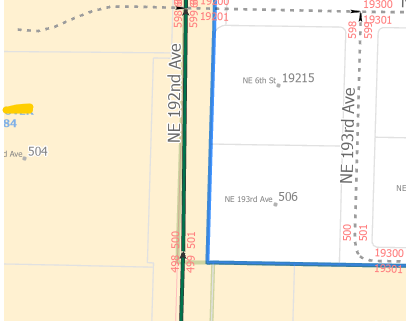
I am in the process of adding attribute rules to our road centerlines in order to speed up the editing workflow. I know how to use Arcade to calculate fields from overlapping features, but is there a way to calculate a field differently depending on what is to the left or right of the polyline? For example, the feature class has a few sets of fields to denote the left and right hand side of each centerline ('L_ZIP', 'R_ZIP', 'L_JURIS', 'R_JURIS', etc). More often than not, these fields match for any given road, however there are segments that either straddle or run closely parallel to those boundaries and the two related values differ. The screenshot below shows an example of an area where this would be applicable for both zipcode and jurisdiction on NE 192nd Ave. Zipcode 1 (indicated by blue boundary line) and city (indicated by beige fill) on the left, zipcode 2 and unincorporated county (white background) on the right.
Is it possible to write an expression to check the zip code/jurisdiction a specified distance in both directions and return that value?