I receive a lot of CAD data for utilities for our local government. When I add a CAD file into ArcGIS Pro, it usually loads in fine, but in a practically unusable way. Here is an example:

As you can see in the first picture there is a ton of large and awkwardly formatted text. If I look at this same file in DWG trueview, it does not look like this. The text is much smaller and doesn't overlap itself.
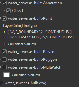
The second, and largest problem is that all of the cad layers are grouped together so you can't cut things off individually. I don't care about 90% of the things in this drawing. I am only interested in water line data. In DWG trueview, I am able to cut the various layers on/off as needed. But when adding the dwg to arcpro, it just lumps all the lines into one file, all the polygons in another, all the points in another, and all the text in another. There is no easy way to quickly toggle the individual layers on/off without diving in and doing definition queries on the layer. Is there an easier way to make this data usable? I don't have ~$2000/year to buy Autocad that allows you to export shapefiles easily. Any other alternatives?



