Hello,
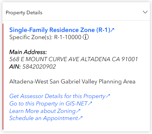
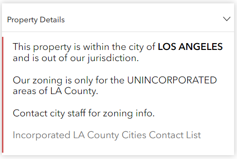
The Arcade Popup displays two different types of popups, depending on which feature type is selected. This is the code:
var GeneralIntersect = Intersects(FeatureSetByName($map, "ZNET_Public - Zoning (Hidden from Map)"), Buffer($feature, -20, "feet"))
var SP_Intersect = Intersects(FeatureSetByName($map, "ZNET_Public - Zoning SP Category (Hidden from Map)"), Buffer($feature, -20, "feet"))
var zone_list = ''
//var zone_d =''
var zone_link = ''
var zone_area =''
var sp_zone = ''
for (var f in GeneralIntersect){
zone_list += f.ZONE + ' '
//zone_d = f.Z_DESC + ' Zone';
zone_link = 'https://library.municode.com/ca/los_angeles_county/codes/code_of_ordinances?nodeId=TIT22PLZO_' + f.TITLE_22
zone_area = Proper(f.NAME) + "-" + f.PLNG_AREA + " Planning Area"
}
for (var g in SP_Intersect){
sp_zone = '- ' + g.PLAN_LEG
}
var revision_text = "";
if ($feature.TaxRateCity != "unincorporated") {
revision_text += "This property is within the city of <b>" + $feature.TaxRateCity + "</b> and is out of our jurisdiction. <br><br>Our zoning is only for the UNINCORPORATED areas of LA County. <br><br>Contact city staff for zoning info.<br><br><a href='https://file.lacounty.gov/SDSInter/lac/1043535_city_webaddress.pdf'>Incorporated LA County Cities Contact List</a>";
}
if (revision_text == "") {
revision_text = "<a href='" + zone_link + "'><font color=#0066ff><b>" + f.Z_DESC + " Zone (" + f.Z_CATEGORY + ")↗</b></font></a><br><span style='font-size:15px;'>Specific Zone(s): " + zone_list + "<span>" + sp_zone + "</span><span title='This may or may not be the same as the zone category above.
It can differ when extra numbers or letters are added to the end,
or when the property is part of a specific plan. Extra numbers
indicate a minimum lot size and letters indicate a combined
zone.'> ⓘ</span><br><br><span style='font-size:15px;'><b><i>Main Address:</i></b><i><br>" + $feature.SitusFullAddress + "</i><br><b><i>AIN:</i></b><i> " + $feature.AIN + "</i><br><br>" + zone_area + "<br><br><a href='https://portal.assessor.lacounty.gov/parceldetail/{AIN}'><font color=#0066ff><i>Get Assessor Details for this Property↗</i></font></a><br><a href='https://rpgis.isd.lacounty.gov/Html5Viewer/index.html?viewer=GISNET_Public.GIS-NET_Public&run=UrlSearch&term={AIN}'><font color=#0066ff><i>Go to this Property in GIS-NET↗</i></font></a><br><a href='https://planning.lacounty.gov/land-use-zoning/'><font color=#0066ff><i>Learn More about Zoning↗</i></font></a><br><a href='https://outlook.office365.com/book/RegionalPlanningVirtualOnlineAppointments@lacounty.onmicrosoft.com/'><font color=#0066ff><i>Schedule an Appointment↗</i></font></a></span>";
}
return {
type : 'text',
text : "<span style=\"display: block; size: '20'; font-size: 16px; text-align: left; padding: 0.5rem; color: black; \">" + revision_text + "</span>"//this property supports html tags
}Popup 1
Popup 2
The app using the web map with this code is currently private. Is it still possible to assess if this was the best way to write this code? Or is there a way to improve so it processes faster?
-Brandon

